-
You are here:
- Homepage » Christmas Island
Christmas Island Country Guide
Explore Christmas Island in Asia
Christmas Island with the capital city The Settlement is located in Asia . It covers some 135 square kilometres with 361 citizens.
The topography includes . The average density of population is approximately 3 per km². The notable climate conditions in Christmas Island can be described as . Possible natural disasters include .
To reach someone in Christmas Island dial +61 prior to a number. There are 0 installed telephones. And there are 0 registered mobile phones. The cellular networks commonly support frequencies of 900 MHz. Websites registered in this country end with the top level domain ".cx". If you want to bring electric equipment on your trip (e.g. laptop power supply), note the local power outlet of 240V - 50Hz.
About the flag and history of Christmas Island
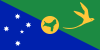
Territorial flag; divided diagonally from upper hoist to lower fly; the upper triangle is green with a yellow image of the Golden Bosun Bird superimposed; the lower triangle is blue with the Southern Cross constellation, representing Australia, superimposed; a centered yellow disk displays a green map of the island note: the flag of Australia is used for official purposes.
Named in 1643 for the day of its discovery, the island was annexed and settlement began by the UK in 1888 with the discovery of the island's phosphate deposits. Following the Second World War, Christmas Island came under the jurisdiction of the new British Colony of Singapore. The island existed as a separate Crown colony from 1 January 1958 to 1 October 1958 when its transfer to Australian jurisdiction was finalized. That date is still celebrated on the first Monday in October as Territory Day. Almost two-thirds of the island has been declared a national park.
Geography Quick-Facts
| Summary | Continent: Asia Neighbours: Capital: The Settlement |
| Size | 135 square kilometers (km² or sqkm) or 52 square miles (mi² or sqmi) |
| Population | 361 |
| Currency | Name Dollar, Currency Code:AUD |
| Country Top Level Domain (cTLD) | .cx |
| Telephone Country Prefix | +61 |
| Mobile Phone Connections | 0 |
| Landline Phone Connections | 0 |
Country Position in World Rankings
Information about single country attributes and how these compare against the rest of the world. The information below is compiled with data from 2013. As such, it may differ a bit to the Information above in the text (which is from 2010).
Geography
| Value name | Value | World Rank |
|---|---|---|
| Area | 135 (sq km) | 222 |
People and Society
| Value name | Value | World Rank |
|---|---|---|
| Population | 1,513 | 234 |
| Population growth rate | 1.12 (%) | 105 |
| Birth rate | -9.00 (births/1,000 population) | 225 |
| Death rate | -9.00 (deaths/1,000 population) | 226 |
| Net migration rate | -999.00 (migrant(s)/1,000 population) | 223 |
Communications
| Value name | Value | World Rank |
|---|---|---|
| Internet hosts | 3,028 | 155 |
| Internet users | 464 | 217 |
Transportation
| Value name | Value | World Rank |
|---|---|---|
| Airports | 1 | 223 |
| Railways | 18 (km) | 133 |
| Roadways | 140 (km) | 211 |
Data based on CIA facts book 2010 & 2013, wikipedia, national statistical offices and their census releases