-
You are here:
- Homepage » Comoros
Comoros Country Guide
Explore Comoros in Africa
The terrain features volcanic islands, interiors vary from steep mountains to low hills. The average density of population is approximately 337 per km². The notable climate conditions in Comoros can be described as tropical marine with rainy season (November to May). Potential natural disasters are cyclones possible during rainy season (December to April) or volcanic activity on Grand Comore.
To reach someone in Comoros dial +269 prior to a number. There are 25,400 installed telephones. And there are 100,000 registered mobile phones. The cellular networks commonly support frequencies of 900 MHz. Websites registered in this country end with the top level domain ".km". If you want to bring electric equipment on your trip (e.g. laptop power supply), note the local power outlet of 220V - 50Hz.
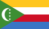
About the flag and history of Comoros
Four equal horizontal bands of yellow (top), white, red, and blue, with a green isosceles triangle based on the hoist; centered within the triangle is a white crescent with the convex side facing the hoist and four white, five-pointed stars placed vertically in a line between the points of the crescent; the horizontal bands and the four stars represent the four main islands of the archipelago - Mwali, N'gazidja, Ndzuwani, and Mahore (Mayotte - territorial collectivity of France, but claimed by Comoros) note: the crescent, stars, and color green are traditional symbols of Islam.
Comoros has endured more than 20 coups or attempted coups since gaining independence from France in 1975. In 1997, the islands of Anjouan and Moheli declared independence from Comoros. In 1999, military chief Col. AZALI seized power of the entire government in a bloodless coup, and helped negotiate the 2000 Fomboni Accords power-sharing agreement in which the federal presidency rotates among the three islands, and each island maintains its local government. AZALI won the 2002 federal presidential election, and each island in the archipelago elected its president. AZALI stepped down in 2006 and President SAMBI was elected to office. In 2007, Mohamed BACAR effected Anjouan's de-facto secession from the Union of Comoros, refusing to step down when Comoros'' other islands held legitimate elections in July. The African Union (AU) initially attempted to resolve the political crisis by applying sanctions and a naval blockade to Anjouan, but in March 2008 the AU and Comoran soldiers seized the island. The island''s inhabitants generally welcomed the move. In May 2011, Ikililou DHOININE won the presidency in peaceful elections widely deemed to be free and fair.
Geography Quick-Facts
| Summary | Continent: Africa Neighbours: Capital: Moroni |
| Size | 2,170 square kilometers (km² or sqkm) or 837 square miles (mi² or sqmi) slightly more than 12 times the size of Washington, DC |
| Population | 731,000 |
| Currency | Name Franc, Currency Code:KMF |
| Country Top Level Domain (cTLD) | .km |
| Telephone Country Prefix | +269 |
| Mobile Phone Connections | 100,000 |
| Landline Phone Connections | 25,400 |
Country Position in World Rankings
Information about single country attributes and how these compare against the rest of the world. The information below is compiled with data from 2013. As such, it may differ a bit to the Information above in the text (which is from 2010).
Geography
| Value name | Value | World Rank |
|---|---|---|
| Area | 2,235 (sq km) | 180 |
People and Society
| Value name | Value | World Rank |
|---|---|---|
| Population | 752,288 | 163 |
| Population growth rate | 1.97 (%) | 52 |
| Birth rate | 30.26 (births/1,000 population) | 42 |
| Death rate | 7.97 (deaths/1,000 population) | 101 |
| Net migration rate | -2.63 (migrant(s)/1,000 population) | 171 |
| Maternal mortality rate | 280.00 (deaths/100,000 live births) | 42 |
| Infant mortality rate | 67.12 (deaths/1,000 live births) | 21 |
| Life expectancy at birth | 63.12 (years) | 183 |
| Total fertility rate | 3.93 (children born/woman) | 42 |
| Health expenditures | 4.50 (% of GDP) | 152 |
| HIV/AIDS - adult prevalence rate | 0.10 (%) | 122 |
| HIV/AIDS - people living with HIV/AIDS | 500 | 152 |
| HIV/AIDS - deaths | 100 | 126 |
| Obesity - adult prevalence rate | 4.40 (%) | 164 |
| Children under the age of 5 years underweight | 25.00 (%) | 25 |
| Education expenditures | 7.60 (% of GDP) | 17 |
Economy
| Value name | Value | World Rank |
|---|---|---|
| GDP (purchasing power parity) | 887,400,000 | 207 |
| GDP - real growth rate | 2.50 (%) | 123 |
| GDP - per capita (PPP) | 1,300 | 209 |
| Labor force | 268,500 | 166 |
| Unemployment rate | 20.00 (%) | 159 |
| Taxes and other revenues | 21.10 (% of GDP) | 156 |
| Budget surplus (+) or deficit (-) | -0.60 (% of GDP) | 54 |
| Inflation rate (consumer prices) | 6.00 (%) | 157 |
| Central bank discount rate | 2.21 (%) | 110 |
| Commercial bank prime lending rate | 10.50 (%) | 84 |
| Stock of narrow money | 135,000,000 | 181 |
| Stock of broad money | 212,100,000 | 186 |
| Stock of domestic credit | 139,800,000 | 185 |
| Current account balance | -67,000,000 | 65 |
| Exports | 27,500,000 | 204 |
| Imports | 211,200,000 | 206 |
| Debt - external | 279,300,000 | 180 |
Energy
| Value name | Value | World Rank |
|---|---|---|
| Electricity - production | 52,000,000 (kWh) | 206 |
| Electricity - consumption | 48,360,000 (kWh) | 206 |
| Electricity - installed generating capacity | 6,000 (kW) | 206 |
| Electricity - from fossil fuels | 83.30 (% of total installed capacity) | 89 |
| Electricity - from hydroelectric plants | 16.70 (% of total installed capacity) | 101 |
| Refined petroleum products - consumption | 1,025 (bbl/day) | 200 |
| Refined petroleum products - imports | 1,009 (bbl/day) | 195 |
| Carbon dioxide emissions from consumption of energy | 149,600 (Mt) | 200 |
Communications
| Value name | Value | World Rank |
|---|---|---|
| Telephones - main lines in use | 23,600 | 185 |
| Telephones - mobile cellular | 216,400 | 180 |
| Internet hosts | 14 | 226 |
| Internet users | 24,300 | 187 |
Transportation
| Value name | Value | World Rank |
|---|---|---|
| Airports | 4 | 186 |
| Roadways | 880 (km) | 185 |
| Merchant marine | 149 | 39 |
Military
| Value name | Value | World Rank |
|---|---|---|
| Military expenditures | 2.80 (% of GDP) | 45 |
Data based on CIA facts book 2010 & 2013, wikipedia, national statistical offices and their census releases