-
You are here:
- Homepage »
- Greece »
- West Greece » Nafpaktos

Nafpaktos Destination Guide
Touring Nafpaktos in Greece
Nafpaktos in the region of West Greece with its 18,000 citizens is a city located in Greece - some 106 mi or ( 171 km ) West of Athens , the country's capital city .
Time in Nafpaktos is now 03:31 PM (Thursday) . The local timezone is named " Europe/Athens " with a UTC offset of 2 hours. Depending on your travel resources, these more prominent places might be interesting for you: Ziria, Sinoikismos Ayiou Yeoryiou, Rio, Patras, and Palaia Panayia. Being here already, consider visiting Ziria . We collected some hobby film on the internet . Scroll down to see the most favourite one or select the video collection in the navigation. Check out our recommendations for Nafpaktos ? We have collected some references on our attractions page.
Videos
Nafpaktos
Nafpaktos at west Greece ..
R1150GS TOURING GREEK LANDSCAPES,RIVERS,BEACHES,LAKES ETC
a tour riding my R1150GS at various places in Greece. highlights; 0.17 close up rear wheel off road 01.37 trixonida lake 02.09 evinos river 02.37 strofylia seaside rare forest and lake 05.18 voidokoil ..
Nafpaktos.In the Port
View on the Port of Nafpaktos ..
Nafpaktos photos - Φωτογραφιες Ναυπακτος by Panos Mavromytis
Work from 09 - 2010, various seascapes, landscapes and other beautiful shots. ..
Videos provided by Youtube are under the copyright of their owners.
Interesting facts about this location
Mornos
The Mornos is a river in Phocis and Aetolia-Acarnania in Greece. Its source is in the southwestern part of the Oiti mountains, near the village Mavrolithari, Phocis. It flows towards the south, and enters the Mornos Reservoir near the village Lefkaditi. The dam was completed in 1979. It leaves the reservoir towards the west, near Perivoli. The river continues through a deep, sparsely populated valley, and turns south near Trikorfo.
Located at 38.37 21.85 (Lat./Long.); Less than 3 km away
Dafni, Aetolia-Acarnania
Dafni is a village and a community in the municipality of Nafpaktia, Aetolia-Acarnania, Greece. The community consists of the villages Dafni (also Ano Dafni), Kato Dafni (the largest village of the community) and Trypou, now uninhabited. During the centuries of Ottoman occupation, Dafni was located higher up in the hills in an area called now Old Dafni (Paliodafni); of that settlement only the foundations of a few houses survive. The name Dafni means laurel.
Located at 38.42 21.87 (Lat./Long.); Less than 5 km away
Kastraki, Phocis
Kastraki is a village in Phocis, Greece, part of the municipal unit Efpalio. It is near the left bank of the river Mornos and 3 km from the Gulf of Corinth. It is 3 km west of the village Efpalio and 6 km northeast of the town of Nafpaktos.
Located at 38.42 21.89 (Lat./Long.); Less than 7 km away
Volinaios
The first version of this article has been based in the text of :el:Βολιναίος ποταμός of the Greek Wikipedia published under GFDL. VolinaiosΒολιναίος {{#invoke:InfoboxImage|InfoboxImage|image=|size=|sizedefault=288px|alt=}} {{#invoke:InfoboxImage|InfoboxImage|image=|size=|sizedefault=288px|alt=}}Origin PanachaikoMouth Gulf of Corinth{{#invoke:Coordinates|coord}}{{#coordinates:38.3368|21.8676||||||| |primary |name= }}Basin countries GreeceLocation AchaeaLength approx.
Located at 38.34 21.87 (Lat./Long.); Less than 7 km away
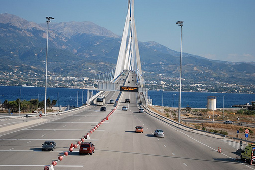
Rio–Antirrio bridge
The Rio–Antirrio bridge, officially the Charilaos Trikoupis bridge after the statesman who first envisaged it, is the world's longest multi-span cable-stayed bridge. It crosses the Gulf of Corinth near Patras, linking the town of Rio on the Peloponnese to Antirrio on mainland Greece by road.
Located at 38.32 21.77 (Lat./Long.); Less than 9 km away
Pictures
Historical Weather
Related Locations
Information of geographic nature is based on public data provided by geonames.org, CIA world facts book, Unesco, DBpedia and wikipedia. Weather is based on NOAA GFS.