-
You are here:
- Homepage »
- Saint Barthélemy »
- Saint Barth » Gustavia
Gustavia Destination Guide
Discover Gustavia in Saint Barthélemy
Gustavia in the region of Saint Barth with its 5,988 habitants is a place located in Saint Barthélemy and is the capital of this country.
Local time in Gustavia is now 01:41 AM (Friday) . The local timezone is named " America/St Barthelemy " with a UTC offset of -4 hours. Depending on your mobility, these larger cities might be interesting for you: Fort-de-France, The Valley, Basseterre, Roseau, and St. John's. When in this area, you might want to check out Fort-de-France . We discovered some clip posted online . Scroll down to see the most favourite one or select the video collection in the navigation. Are you looking for some initial hints on what might be interesting in Gustavia ? We have collected some references on our attractions page.
Videos
Saint Barth airport
Saint Barth airport ..
Episode 13 St. Barths deutsch
Auf St.Barths, dem St.Tropez der Karibik, kann man nicht nur gut essen. Bei der Bucket Regatta segeln wir Helios, eine Perini Navi und dann zum Sieg auf Meteor, einem bildschönen Royal Huisman Schoone ..
St. Barth Landing
The landing strip in St. Barth is about the length of the one on Middle Bass Island - less than 2000 ft. But the one in St. Barth has a mountain on one end and the beach on the other. Only specially t ..
Cyclone Earl St Barth - Enorme vague
Grosse houle dans le port de Gustavia au passage du cyclone Earl ..
Videos provided by Youtube are under the copyright of their owners.
Interesting facts about this location
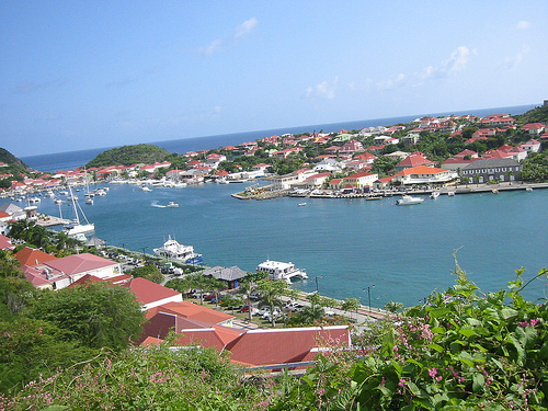
Gustavia, Saint Barthélemy
Gustavia is the main town and capital of the island of Saint Barthélemy (often abbreviated to Saint-Barth in French, or St. Barts in English). It was named for King Gustav III of Sweden.
Located at 17.90 -62.85 (Lat./Long.); Less than 0 km away
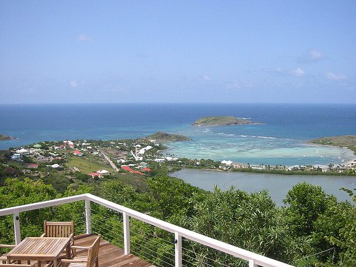
Saint Barthélemy
Saint Barthélemy, officially the Territorial collectivity of Saint Barthélemy (French: Collectivité territoriale de Saint-Barthélemy), is an overseas collectivity of France. Often abbreviated to Saint-Barth in French, or St. Barts or St. Barths in English, the indigenous people called the island Ouanalao. St. Barts lies about 35 km (21.75 mi) southeast of Sint Maarten/Saint Martin, and north of St. Kitts. Puerto Rico is 240 km (149.1 mi) to its west in the Lesser Antilles.
Located at 17.90 -62.83 (Lat./Long.); Less than 2 km away
Île Fourchue
Île Fourchue, also known as Île Fourche is an island between Saint-Barthélemy and Saint Martin, belonging to the Collectivity of Saint Barthélemy. The island is privately owned. The only inhabitants are some goats. The highest point is 103 meter above sea level.
Located at 17.96 -62.90 (Lat./Long.); Less than 9 km away
Saint-Barthélemy Channel
Saint-Barthélemy Channel is a strait in the Caribbean Sea that separates the French overseas collectivity of Saint Barthélemy and the island of Saint Martin, which is divided between a separate French overseas collectivity and Sint Maarten, a constituent country of the Kingdom of the Netherlands. The maritime boundary between Saint Bathélemy and Sint Maarten runs through Saint-Barthélemy Channel.
Located at 17.98 -62.98 (Lat./Long.); Less than 17 km away
Arrondissement of Saint-Martin-Saint-Barthélemy
The arrondissement of Saint-Martin-Saint-Barthélemy is a former arrondissement of France, formerly located in the Guadeloupe département, in the Guadeloupe région. It had 3 cantons and 2 communes. It ceased to exist on February 22, 2007 when the communes of Saint-Martin and Saint Barthelemy were officially detached from Guadeloupe. 20px This section requires expansion.
Located at 18.00 -63.00 (Lat./Long.); Less than 20 km away
Pictures


Related Locations


Information of geographic nature is based on public data provided by geonames.org, CIA world facts book, Unesco, DBpedia and wikipedia. Weather is based on NOAA GFS.