-
You are here:
- Homepage » Sao Tome and Principe
Sao Tome and Principe Country Guide
Explore Sao Tome and Principe in Africa
The landscape offers volcanic, mountainous. The average density of population is approximately 205 per km². The notable climate conditions in Sao Tome and Principe can be described as tropical with hot, humid and one rainy season (October to May). Potential threats by nature are NA.
To reach someone in Sao Tome and Principe dial +239 prior to a number. There are 7,800 installed telephones. And there are 64,000 registered mobile phones. The cellular networks commonly support frequencies of 900 MHz. Websites registered in this country end with the top level domain ".st". If you want to bring electric equipment on your trip (e.g. laptop power supply), note the local power outlet of 220V - 50Hz.
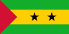
About the flag and history of Sao Tome and Principe
Three horizontal bands of green (top), yellow (double width), and green with two black five-pointed stars placed side by side in the center of the yellow band and a red isosceles triangle based on the hoist side; green stands for the country's rich vegetation, red recalls the struggle for independence, and yellow represents cocoa, one of the country's main agricultural products; the two stars symbolize the two main islands note: uses the popular Pan-African colors of Ethiopia.
Discovered and claimed by Portugal in the late 15th century, the islands'' sugar-based economy gave way to coffee and cocoa in the 19th century - all grown with African plantation slave labor, a form of which lingered into the 20th century. While independence was achieved in 1975, democratic reforms were not instituted until the late 1980s. The country held its first free elections in 1991, but frequent internal wrangling between the various political parties precipitated repeated changes in leadership and two failed coup attempts in 1995 and 2003. In 2012, three opposition parties combined in a no confidence vote to bring down the majority government of former Prime Minister Patrice TROVOADA. The new government of Prime Minister Gabriel Arcanjo Ferreira DA COSTA is entirely composed of opposition party members with limited experience in governance. The recent discovery of oil in the Gulf of Guinea promises to attract increased attention to the small island nation.
Geography Quick-Facts
| Summary | Continent: Africa Neighbours: Capital: São Tomé |
| Size | 1,001 square kilometers (km² or sqkm) or 386 square miles (mi² or sqmi) more than five times the size of Washington, DC |
| Population | 205,000 |
| Currency | Name Dobra, Currency Code:STD |
| Country Top Level Domain (cTLD) | .st |
| Telephone Country Prefix | +239 |
| Mobile Phone Connections | 64,000 |
| Landline Phone Connections | 7,800 |
Country Position in World Rankings
Information about single country attributes and how these compare against the rest of the world. The information below is compiled with data from 2013. As such, it may differ a bit to the Information above in the text (which is from 2010).
Geography
| Value name | Value | World Rank |
|---|---|---|
| Area | 964 (sq km) | 185 |
People and Society
| Value name | Value | World Rank |
|---|---|---|
| Population | 186,817 | 185 |
| Population growth rate | 1.94 (%) | 58 |
| Birth rate | 36.05 (births/1,000 population) | 21 |
| Death rate | 7.68 (deaths/1,000 population) | 109 |
| Net migration rate | -8.96 (migrant(s)/1,000 population) | 208 |
| Maternal mortality rate | 70.00 (deaths/100,000 live births) | 87 |
| Infant mortality rate | 50.48 (deaths/1,000 live births) | 42 |
| Life expectancy at birth | 63.86 (years) | 177 |
| Total fertility rate | 4.81 (children born/woman) | 23 |
| Health expenditures | 7.20 (% of GDP) | 76 |
| Obesity - adult prevalence rate | 9.50 (%) | 132 |
| Children under the age of 5 years underweight | 14.40 (%) | 53 |
Economy
| Value name | Value | World Rank |
|---|---|---|
| GDP (purchasing power parity) | 408,600,000 | 217 |
| GDP - real growth rate | 4.00 (%) | 80 |
| GDP - per capita (PPP) | 2,400 | 184 |
| Labor force | 52,490 | 189 |
| Investment (gross fixed) | 50.10 (% of GDP) | 1 |
| Taxes and other revenues | 42.20 (% of GDP) | 36 |
| Budget surplus (+) or deficit (-) | -10.80 (% of GDP) | 208 |
| Public debt | 76.50 (% of GDP) | 31 |
| Inflation rate (consumer prices) | 10.20 (%) | 199 |
| Central bank discount rate | 28.00 (%) | 4 |
| Commercial bank prime lending rate | 26.75 (%) | 9 |
| Stock of narrow money | 37,510,000 | 187 |
| Stock of broad money | 80,550,000 | 190 |
| Stock of domestic credit | 87,120,000 | 186 |
| Industrial production growth rate | 7.00 (%) | 40 |
| Current account balance | -85,100,000 | 68 |
| Exports | 11,900,000 | 213 |
| Imports | 121,900,000 | 210 |
| Reserves of foreign exchange and gold | 44,700,000 | 166 |
| Debt - external | 316,600,000 | 178 |
Energy
| Value name | Value | World Rank |
|---|---|---|
| Electricity - production | 32,000,000 (kWh) | 210 |
| Electricity - consumption | 29,760,000 (kWh) | 210 |
| Electricity - installed generating capacity | 14,000 (kW) | 198 |
| Electricity - from fossil fuels | 57.10 (% of total installed capacity) | 142 |
| Electricity - from hydroelectric plants | 42.90 (% of total installed capacity) | 52 |
| Refined petroleum products - consumption | 904 (bbl/day) | 208 |
| Refined petroleum products - imports | 889 (bbl/day) | 197 |
| Carbon dioxide emissions from consumption of energy | 150,300 (Mt) | 199 |
Communications
| Value name | Value | World Rank |
|---|---|---|
| Telephones - main lines in use | 8,000 | 204 |
| Telephones - mobile cellular | 115,000 | 189 |
| Internet hosts | 1,678 | 165 |
| Internet users | 26,700 | 184 |
Transportation
| Value name | Value | World Rank |
|---|---|---|
| Airports | 2 | 206 |
| Roadways | 320 (km) | 202 |
| Merchant marine | 3 | 136 |
Military
| Value name | Value | World Rank |
|---|---|---|
| Military expenditures | 0.50 (% of GDP) | 162 |
Data based on CIA facts book 2010 & 2013, wikipedia, national statistical offices and their census releases