-
You are here:
- Homepage »
- Spain »
- Canary Islands » Pájara

Pájara Destination Guide
Explore Pájara in Spain
Pájara in the region of Canary Islands with its 20,821 inhabitants is a town in Spain - some 1,022 mi or ( 1644 km ) South-West of Madrid , the country's capital city .
Current time in Pájara is now 01:23 PM (Wednesday) . The local timezone is named " Atlantic/Canary " with a UTC offset of 0 hours. Depending on the availability of means of transportation, these more prominent locations might be interesting for you: El Aaiún, Valles de Ortega, Valle de Santa Ines, Triquivijate, and Telde. Since you are here already, make sure to check out El Aaiún . We saw some video on the web . Scroll down to see the most favourite one or select the video collection in the navigation. Where to go and what to see in Pájara ? We have collected some references on our attractions page.
Videos
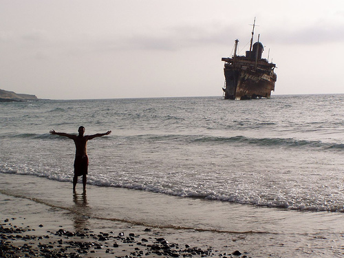
The Decay Continues ... The Last Remains of the American Star
Documentation of the status of the American Star in February 2011 at the Playa de Garcey. www.american-star.eu ..
Fuerteventura - Stürmische Küste Schiffswrack
PMMedia1: Unsere Fahrt an die Westküste Fuerteventuras führt über den Fenduca-Pass hinauf nach Pajara. Von den Steilhängen ergibt sich ein herrlicher Blick auf die Bergwelt der Insel. Über eine beschw ..
GTA IV PARQUE DE ATRACCIONES TRUCO
GTA IV PARQUE DE ATRACCIONES TRUCO PS3 ..
Downhill Fuerteventura On Road FV-30
One nice downhill section of the road FV-30, Fuerteventura. No so fast but nice turns. R: Jerry C: Chukson ..
Videos provided by Youtube are under the copyright of their owners.
Interesting facts about this location
Pájara
Pájara is a Canarian municipality in the central and the eastern portion of the island of Fuerteventura in the Las Palmas province in the Canary Islands. Its population is 16,279, its population density is 42.46/km² and its area is 383.52 km². The municipality includes a small peninsula to the southwest. Pájara is both the southernmost and the westernmost municipality on the island.
Located at 28.35 -14.10 (Lat./Long.); Less than 1 km away
Tuineje, Las Palmas
Tuineje is a Canarian municipality in the central and the eastern portion of the island of Fuerteventura in the Las Palmas province in the Canary Islands The population is 11,261, its density is 40.81/km² and the area is 275.94 km². It is located a main highway linking Antigua and Pájara. The main industry are agriculture and tourism. The Atlantic Ocean is to the south and east, the mountains covers the north and west. Farmlands dominate the rest of the municipality.
Located at 28.32 -14.05 (Lat./Long.); Less than 7 km away
SS America (1940)
SS America was an ocean liner built in 1940 for the United States Lines and designed by the noted naval architect William Francis Gibbs. She carried many names in the 54 years between her construction and her 1994 wrecking, as she served as the SS America (carrying this name three different times during her career), the USS West Point, the SS Australis, the SS Italis, the SS Noga, the SS Alferdoss, and the SS American Star.
Located at 28.35 -14.18 (Lat./Long.); Less than 7 km away
Ajuy
Ajuy is a small remote fishing village on the west coast of Fuerteventura in the Canary Islands. Not far from Ajuy is where the Norman Jean de Béthencourt landed in order to conquer the island for the Spanish crown. Puerto de la Peña is a small settlement of Ajuy and used to serve as a port of the old island capital of Betancuria. The port was later raided by pirates. Ajuy features a black-sand beach that is circled and are surrounded between the mountains and the small hills to the east.
Located at 28.40 -14.16 (Lat./Long.); Less than 7 km away
Fuerteventura
Fuerteventura (Roughly translates into 'Strong Fortune') is one of the Canary Islands, in the Atlantic Ocean off the coast of Africa, politically part of Spain. At 1,660 km² it is the second largest of the Canary Islands, after Tenerife. It was declared a biosphere reserve by UNESCO on 26 May 2009.
Located at 28.33 -14.02 (Lat./Long.); Less than 9 km away
Pictures
Related Locations
Information of geographic nature is based on public data provided by geonames.org, CIA world facts book, Unesco, DBpedia and wikipedia. Weather is based on NOAA GFS.