-
You are here:
- Homepage »
- United Kingdom »
- Scotland » Ardersier

Ardersier Destination Guide
Explore Ardersier in United Kingdom
Ardersier in the region of Scotland with its 929 inhabitants is a place in United Kingdom - some 447 mi or ( 719 km ) North of London , the country's capital city .
Time in Ardersier is now 09:10 AM (Thursday) . The local timezone is named " Europe/London " with a UTC offset of 0 hours. Depending on your budget, these more prominent locations might be interesting for you: York, Perth, Nigg, Nairn, and Leeds. Since you are here already, consider visiting York . We saw some hobby film on the internet . Scroll down to see the most favourite one or select the video collection in the navigation. Where to go and what to see in Ardersier ? We have collected some references on our attractions page.
Videos
EGPE Landing PA38 Tomahawk Runway 23
Inverness Highlands UK, PA38 Tomahawk ..
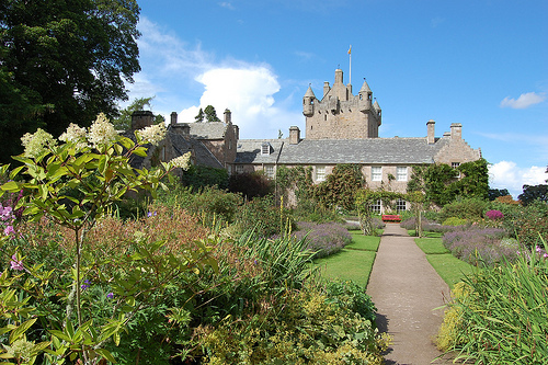
Cawdor Castle Scotland
Scotland renowned for it's castles, Cawdor Castle is one such castle set in its own grounds in the Scotish highlands very picturesque as your about to see. ..
Spring Day Chanonry Point 17 February, 2009
..
Inverness, Scotland - The Highland Aviation Museum
A short video showing a slideshow of the varied aviation exhibits at the Highland Aviation Museum, located at Inverness Airport, Scotland. Well worth a visit to see them and browse through the museum, ..
Videos provided by Youtube are under the copyright of their owners.
Interesting facts about this location
Gollanfield Junction railway station
Gollanfield Junction was a railway station located at Gollanfield, to the west of Nairn, Scotland, (now in the Highland Council Area).
Located at 57.55 -4.01 (Lat./Long.); Less than 2 km away
Moray Firth School
Moray Firth School was an independent school located at Gollanfield, between Inverness and Nairn in the Highland council area of Scotland. It was the only independent school in the region.
Located at 57.56 -3.99 (Lat./Long.); Less than 3 km away
Highland Aviation
Highland Aviation Training Ltd is a registered training facility at Inverness Airport. Highland Aviation provides training towards JAR FCL Private Pilots License (PPL) and the UK National Private Pilots License (NPPL). It also provides training for the UK IMC rating and the night rating. In addition to these ratings Highland Aviation also provides beach landing courses and mountain flying training.
Located at 57.54 -4.06 (Lat./Long.); Less than 3 km away
Chanonry Point
Chanonry Point lies at the end of Chanonry Ness, a spit of land extending into the Moray Firth between Fortrose and Rosemarkie on the Black Isle, Scotland. Chanonry Point is one of the best spots in the UK to view Bottlenose dolphin Tursiops truncatus from the land. The dolphins are often visible off Chanonry point, particularly on an incoming tide when they play and fish in the strong currents. Other wildlife, including porpoises and grey seals, can also regularly be spotted.
Located at 57.57 -4.10 (Lat./Long.); Less than 4 km away
Cromartyshire
Cromartyshire (Siorrachd Chromba in Gaelic) was a county in the Highlands of Scotland, consisting of a main portion between Sutherland and Ross-shire and a series of exclaves within Ross-shire. Ross-shire and Cromartyshire were combined as the single county of Ross and Cromarty by the Local Government (Scotland) Act 1889, and this became part of the Highland region in 1975. The only burgh of Cromartyshire was the county town, Cromarty.
Located at 57.60 -4.00 (Lat./Long.); Less than 4 km away
Pictures

Related Locations
Information of geographic nature is based on public data provided by geonames.org, CIA world facts book, Unesco, DBpedia and wikipedia. Weather is based on NOAA GFS.