
Delve into Plomelin in France
Plomelin in the region of Bretagne with its 4,318 residents is located in France - some 305 mi or ( 490 km ) West of Paris , the country's capital .
Local time in Plomelin is now 11:47 PM (Saturday) . The local timezone is named " Europe/Paris " with a UTC offset of 1 hours. Depending on your mobility, these larger destinations might be interesting for you: Oxford, Bristol, Saint-Jean-Trolimon, Rest, and Pontivy. While being here, you might want to check out Oxford . We discovered some clip posted online . Scroll down to see the most favourite one or select the video collection in the navigation. Are you curious about the possible sightseeing spots and facts in Plomelin ? We have collected some references on our attractions page.
Videos
DANCE BRETONNE FEST NOZ ILE TUDY, Finistère, Bretagne
MUSIQUE BRETONNE Retrouvez toutes les photos sur www.flickr.com regardsurlefinistere.over-blog.fr ..
Ireland's Call.wmv
Ireland's Call est un chant irlandais utilisé comme hymne lors des matches internationaux de l'Équipe d'Irlande de rugby à XV. La chanson a été écrite par Phil Coulter en 1995 suite à une commande de ..
New world inverse reverse
moins impressionnant que le géant Bomber maxxx de 2010. Mais le roulis de la nacelle vous donne d'autres sensations plus recherchées. 4/5 G assurés. ..
Tanzende Bretonen
In der Bretagne spielen Traditionen eine wichtige Rolle. Auf Folklorefesten (und auch sonst) wird viel getanzt. Hier in Quimper und Concarneau. ..
Videos provided by Youtube are under the copyright of their owners.
Interesting facts about this location
Quimper – Cornouaille Airport
Quimper – Cornouaille Airport or Aéroport de Quimper - Cornouaille is an airport located in Pluguffan and 5.5 km southwest of Quimper, both communes of the Finistère département in the Brittany région of France.
Located at 47.97 -4.17 (Lat./Long.); Less than 5 km away
Parc botanique de Cornouaille
The Parc botanique de Cornouaille (4 hectares) is a botanical garden located in Kerlever, Combrit, Finistère, Brittany, France. It is open daily in the warmer months; an admission fee is charged. The garden was established by Jean-Pierre Gueguen in 1981. Today it contains about 3500 plant varieties, with good collections of camelias (550 varieties), rhododendrons (400), magnolias (85), azaleas (80), and hortensias (60).
Located at 47.89 -4.19 (Lat./Long.); Less than 6 km away
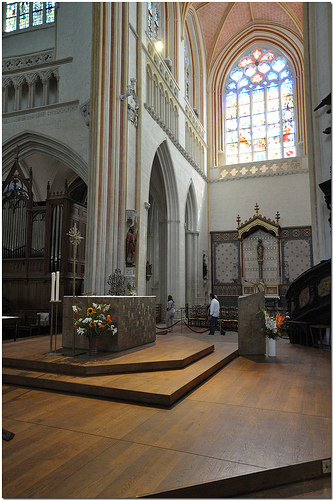
Quimper Cathedral
Quimper Cathedral (Cathédrale Saint-Corentin de Quimper) is a Roman Catholic cathedral, and national monument of Brittany, located in the town of Quimper. It is the seat of the Bishops of Quimper (now Bishops of Quimper-Leon), to the first of whom, Saint Corentin, it is dedicated. The cathedral is notable in that unlike other Gothic cathedrals it slightly bends in the middle to match the contours of its location, and avoid an area that was swampy at the time of the construction.
Located at 48.00 -4.10 (Lat./Long.); Less than 8 km away
Odet
The Odet is a river in western France, which runs from Saint-Goazec into the Atlantic Ocean at Bénodet. Bénodet is being given its name from the river (Ben means river mouth in Breton. The river is popular with kayakers. The river runs past, or through, the towns of Bénodet, Combrit, Plomelin, Quimper, Ergué-Gabéric, Briec-de-l'Odet, Langolen, Coray, Trégourez, Leuhan and Saint-Goazec
Located at 47.86 -4.10 (Lat./Long.); Less than 9 km away
Pointe de la Torche
Pointe de la Torche (Breton: Beg an Dorchenn) is a promontory located at the southeastern end of the Baie d'Audierne in the commune of Plomeur in the Bigouden region of Finistère, France. It is an officially recognised natural site and at the top of the promontory is a prehistoric settlement and burial site that is registered as a historic monument.
Located at 47.84 -4.35 (Lat./Long.); Less than 19 km away
Pictures


Related Locations
Information of geographic nature is based on public data provided by geonames.org, CIA world facts book, Unesco, DBpedia and wikipedia. Weather is based on NOAA GFS.