-
You are here:
- Homepage »
- France »
- Haute-Normandie » Étretat

Étretat Destination Guide
Explore Étretat in France
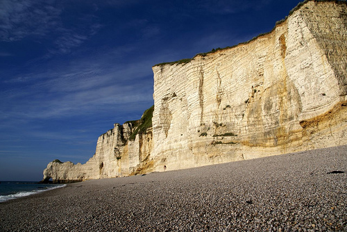
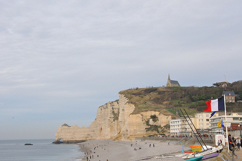
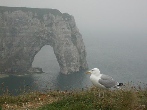
Étretat in the region of Haute-Normandie with its 1,658 inhabitants is a town in France - some 113 mi or ( 182 km ) North-West of Paris , the country's capital city .
Current time in Étretat is now 02:15 PM (Tuesday) . The local timezone is named " Europe/Paris " with a UTC offset of 1 hours. Depending on the availability of means of transportation, these more prominent locations might be interesting for you: London, Cambridge, Bristol, Birmingham, and Yport. Since you are here already, make sure to check out London . We encountered some video on the web . Scroll down to see the most favourite one or select the video collection in the navigation. Where to go and what to see in Étretat ? We have collected some references on our attractions page.
Videos
Les falaises d'Etretat
Les falaises d'Etretat (en normandie) ..
Normandy - Part 1
Admiring the beauty of the Norman coast. A trip from Etretat to Deauville. Part one of my documentary about Normandy. ..
BRETAGNA TIM JANIS :ETRETAT 12 agosto 2009
ORE RILASSANTI A GUARDARE L'OCEANO E LE SCOGLIERE DI ETRETAT ..
Vidéo photos Etretat 2011 par Landry Lachèvre
Toute ma galerie de photos par ce lien: cestavoir.free.fr ..
Videos provided by Youtube are under the copyright of their owners.
Interesting facts about this location
Operation Biting
Operation Biting, also known as the Bruneval Raid, was the codename given to a British Combined Operations raid on a German radar installation in Bruneval, northern France, that occurred between 27–28 February 1942 during World War II. A number of these installations had been identified from Royal Air Force aerial reconnaissance during 1941, but their exact purpose and the nature of the equipment that they possessed was not known.
Located at 49.67 0.16 (Lat./Long.); Less than 5 km away
Valmont (river)
The river Valmont is one of the small rivers that flow from the plateau of the Pays de Caux into the English Channel. The river rises at an altitude of 56m at the commune of Valmont at a place called le Vivier. It takes a northwest orientation and falls by a slope of 2,8%, passing through the commune of Colleville before joining the sea via the port of Fécamp.
Located at 49.76 0.37 (Lat./Long.); Less than 13 km away
Côte d'Albâtre
The Côte d'Albâtre (literally the Alabaster Coast) is part of the French coast of the English Channel, corresponding to the coastline of Pays de Caux and forming almost all of the coastline of Seine-Maritime. Since 2009 it has been classified as a Natura 2000 site.
Located at 49.77 0.37 (Lat./Long.); Less than 13 km away
Fécamp Abbey
Fécamp Abbey (French: Abbaye de la Trinité de Fécamp) is a Benedictine abbey in Normandy, northern France. The abbey was the first producer of Bénédictine, a herbal liqueur, based on brandy.
Located at 49.76 0.38 (Lat./Long.); Less than 14 km away
SS Galeka
SS Galeka was a steam ship originally built for the Union-Castle Mail Steamship Company, but requisitioned for use as a British troop transport and then a hospital ship during the First World War. On 28 October 1916 she hit a mine laid by the German U-boat UC-26.
Located at 49.57 0.08 (Lat./Long.); Less than 18 km away
Pictures

Historical Weather
Related Locations
Information of geographic nature is based on public data provided by geonames.org, CIA world facts book, Unesco, DBpedia and wikipedia. Weather is based on NOAA GFS.