-
You are here:
- Homepage »
- France »
- Languedoc-Roussillon » Latour-de-France

Latour-de-France Destination Guide
Touring Latour-de-France in France
Latour-de-France in the region of Languedoc-Roussillon with its 964 citizens is a city located in France - some 421 mi or ( 677 km ) South of Paris , the country's capital city .
Time in Latour-de-France is now 01:47 PM (Saturday) . The local timezone is named " Europe/Paris " with a UTC offset of 1 hours. Depending on your travel resources, these more prominent places might be interesting for you: Vinca, Villeneuve-la-Riviere, Toulouse, Thuir, and Perpignan. Being here already, consider visiting Vinca . We collected some hobby film on the internet . Scroll down to see the most favourite one or select the video collection in the navigation. Check out our recommendations for Latour-de-France ? We have collected some references on our attractions page.
Videos
Château de Quéribus
© zoqy.net A look round Château de Quéribus For all of my latest videos, please check-out and subscribe to my new YouTube channel www.youtube.com ..
RIBERACH France 3 Octobre 2009
La Cave coopérative de Bélesta dans le Roussillon, est en train d'être transformée en cave-hôtel-restaurant haut de gamme. Un pari, un challenge, un projet architectural colossal. 18 chambres design d ..
Trithemis annulata
Trithemis annulata lac de Millas Pyrénés-Orientales 10 2011 ..
Sentier Cathare, Quéribus (Wind).
sentier cathare 2011 ..
Videos provided by Youtube are under the copyright of their owners.
Interesting facts about this location
Força Réal
Força Réal is a rocky peak overlooking the region of Roussillon in Southern France. From the height of 507 metres, it has a view that stretches from the peak of the Canigou to the cape of Port-Vendres. From here, one can see the geographically contrasting valleys of the Agly and the Têt. It has been used historically as a lighthouse, on account of its unique shape and proximity to the ports of Roussillon.
Located at 42.73 2.70 (Lat./Long.); Less than 6 km away
Maury AOC
Maury is an Appellation d'Origine Contrôlée (AOC) for fortified vin doux naturel wines made in the Roussillon wine region of France. Almost all wines are red, made from at least 75% Grenache Noir (Garnacha). Other permitted grapes are Grenache Blanc, Grenache Gris, Macabeu (Macabeo), Malvoisie du Roussillon (Tourbat), Syrah, Muscat and other local varieties. Although the grapes are different, they are used and marketed very like port.
Located at 42.81 2.59 (Lat./Long.); Less than 7 km away
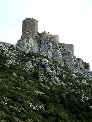
Château de Quéribus
The Château de Quéribus (in Occitan Castèl de Queribús) is a ruined castle in the commune of Cucugnan in the Aude département of France. It has been listed as a monument historique by the French Ministry of Culture since 1907. Queribus is one of the "Five Sons of Carcassonne", along with Aguilar, Peyrepertuse, Termes and Puilaurens: five castles strategically placed to defend the French border against the Spanish, until the border was moved in 1659.
Located at 42.84 2.62 (Lat./Long.); Less than 8 km away
Abetxuko Bridge
The Abetxuko Bridge is a steel girder bridge with organic forms in Vitoria-Gasteiz, Álava, Basque Country, Spain. The Abetxuko Bridge over the Zadorra River is one of several projects being built by Vitoria council to improve mobility for its citizens and, above all, for the inhabitants of the Abetxuko area who for several decades have only been able to reach the city centre via an old, 6-metre -wide bridge. The narrow deck only has space for two carriageways and for narrow pedestrian walkways.
Located at 42.85 2.68 (Lat./Long.); Less than 9 km away
Corbières (mountains)
The Corbières is a mountain range in the Pre-Pyrenees.
Located at 42.84 2.75 (Lat./Long.); Less than 11 km away
Pictures
Historical Weather
Related Locations
Information of geographic nature is based on public data provided by geonames.org, CIA world facts book, Unesco, DBpedia and wikipedia. Weather is based on NOAA GFS.