-
You are here:
- Homepage »
- France »
- Rhone-Alpes » Mens

Mens Destination Guide
Discover Mens in France
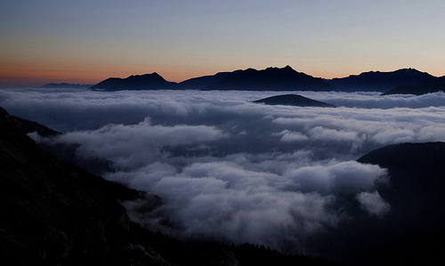
Mens in the region of Rhône-Alpes with its 1,325 habitants is a town located in France - some 322 mi or ( 518 km ) South-East of Paris , the country's capital .
Local time in Mens is now 10:01 AM (Sunday) . The local timezone is named " Europe/Paris " with a UTC offset of 1 hours. Depending on your flexibility, these larger cities might be interesting for you: Valence, Valbonnais, Treffort, Serre de Milmaze, and Ser Clapi. When in this area, you might want to check out Valence . We found some clip posted online . Scroll down to see the most favourite one or select the video collection in the navigation. Are you looking for some initial hints on what might be interesting in Mens ? We have collected some references on our attractions page.
Videos
Il giardino di Lucia (2005) - Alberto Cima Film Maker
Tréminis, Grenoble, France. Lucy emigrated with her husband Battista in 1952. Children of poverty in the post-war years. A small world, only 2 years of school, family and church. Their four children a ..
Ponsonnas tandem bungee by Billy and Naomi
Billy & Na tandem jump off Ponsonnas Bridge, Grenoble, France ..
Bungee Jump from the 103mt Ponsonnas Bridge
This is my first, but hopefully not last extreme Bungee Jump (saute de elestique) from the Mighty 103 mt Ponsonnas Brige near Grenoble in France.The 103 metre high Ponsonnas bridge is one of the highe ..
Le gite Clévacances de Mens en Trièves
Tél: : 04 76 34 89 07 - 06 77 24 32 82 Courriel : cathvanrie@yahoo.fr Site: lapetitemaison.unblog.fr Vos vacances à Mens, capitale du Trièves, une région magique de moyenne montagne située entre le Ve ..
Videos provided by Youtube are under the copyright of their owners.
Interesting facts about this location
La Salette, Isère
La Salette is a small mountaintop village near Grenoble, France. It is part of the commune of La Salette-Fallavaux, which is situated in the Isère-département in the Rhône-Alpes-region. It is most noted for an apparition of the Virgin Mary that was reported in 1846 by two shepherd children, Mélanie Calvat and Maximin Giraud, followed by numerous accounts of miraculous healings.
Located at 44.82 5.95 (Lat./Long.); Less than 16 km away
La Jarjatte
La Jarjatte is a hamlet in the French Dauphiné Alps. Situated at around 1100m, close to the source of the river Buëch, it is part of the commune of Lus-la-Croix-Haute in the Drôme department. Popular with walkers and hikers in the summer, the village has a via ferrata route, a local ski station and over 18 km of cross-country skiing trails. It is bordered on the east by the Dévoluy massif, and the Vercors to the west. Grenoble is the nearest major city, about 75 km away to the north.
Located at 44.68 5.76 (Lat./Long.); Less than 16 km away
Pierre Percée
The Pierre Percée is a natural arch located on a hill of Matheysine, in the Isère département, upon the commune of Pierre-Châtel. It belongs to the so-called Seven Wonders of Dauphiné. Internal gap is 3m. high. Overall aspect evokes the one of a crouching monster and has been the origin of many local legends, where the Devil is usually involved.
Located at 44.97 5.76 (Lat./Long.); Less than 16 km away
Lac de Monteynard-Avignonet
Lac de Monteynard-Avignonet is an artificial water reservoir for the Électricité de France power station on the Drac River. It belongs to the department of Isère. It is bounded by the canyons of the Drac and Ebron. The lake was created in 1961, when the 145-metre-high dam was built. The lake is 10 kilometres long, and in some places up to 300 metres wide. This lake is often windy and wavy. It is considered to be one of the best places for windsurfing and kitesurfing in Europe.
Located at 44.96 5.69 (Lat./Long.); Less than 17 km away
Matheysine
Matheysine is a French Natural region located in the Alps at the south of the Isère département. Its relief is a plateau surroundered by mountains. Matheysine is also called Plateau Matheysin.
Located at 44.97 5.78 (Lat./Long.); Less than 17 km away
Pictures


Historical Weather
Related Locations
Information of geographic nature is based on public data provided by geonames.org, CIA world facts book, Unesco, DBpedia and wikipedia. Weather is based on NOAA GFS.