
Explore Poros in Greece
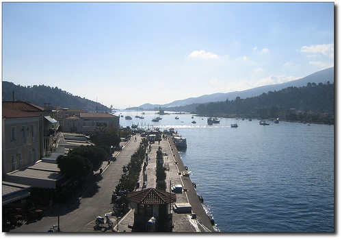
Poros in the region of Attica with its 4,454 inhabitants is a town in Greece - some 36 mi or ( 58 km ) South-West of Athens , the country's capital city .
Current time in Poros is now 02:46 PM (Saturday) . The local timezone is named " Europe/Athens " with a UTC offset of 2 hours. Depending on the availability of means of transportation, these more prominent locations might be interesting for you: Vromolimni, Vlakhaiika, Troizinia, Taktikoupolis, and Lacedaemon. Since you are here already, make sure to check out Vromolimni . We encountered some video on the web . Scroll down to see the most favourite one or select the video collection in the navigation. Where to go and what to see in Poros ? We have collected some references on our attractions page.
Videos
Gyros Souvlaki - ΠΙΤΕΣ - to Κήμα - the wave - Poros Island - Greece
making of greek gyros pita souvlaki / ΠΙΤA (greek fast food) ..
ΠΟΡΟΣ-ΑΣΚΕΛΙ & DIANA ROOMS
ΕΝΟΙΚΙΑΖΟΜΕΝΑ ΔΩΜΑΤΙΑ ΣΤΟ ΑΣΚΕΛΙ ΤΟΥ ΠΟΡΟΥ,ΤΗΣ ΟΙΚΟΓΕΝΕΙΑΣ ΣΠΥΡΤΖΗ. ..
Trip to Poros island with Suba (Impreza chasing Evo)
Ekdromoula ston Poro me tous Subamaniacs ..
POROS 2011
..
Videos provided by Youtube are under the copyright of their owners.
Interesting facts about this location
Galatas, Troizina
Galatas, is a town located in the eastern part of the Peloponnese peninsula, Greece. It is the seat of the municipality of Troizinia, which belongs to the Islands regional unit. It is situated on the coast, opposite the island Poros, across a 400 m wide strait. The community Galatas consists of the main town Galatas and the villages Agia Sotira, Vlachaiika and Saronida.
Located at 37.50 23.45 (Lat./Long.); Less than 1 km away
Kalaureia
Kalaureia or Calauria is an island close to the coast of Troezen in the Peloponnesus of mainland Greece, part of the modern island-pair Poros. Strabo describes the coastwise journey along the Hermionic Gulf: "The gulf begins at the town of Asine. Then come Hermione and Troezen; and, as one sails along the coast, one comes also to the island of Calauria, which has a circuit of one hundred and thirty stadia and is separated from the mainland by a strait four stadia wide."
Located at 37.52 23.48 (Lat./Long.); Less than 3 km away
Megalochori, Methana
Megalochori is a village located in the northwestern part of the Methana peninsula. It is located in a valley northwest of the volcanic summit. It is located W of Methana, E of Ligouri, NE of Kranidi, ENE of Ermioni, NW of Troizina and W of Poros.
Located at 37.59 23.36 (Lat./Long.); Less than 13 km away
Kypseli, Methana
Kypseli is situated in the eastern part of the Methana volcanic peninsula. It was originally a farming village.
Located at 37.61 23.40 (Lat./Long.); Less than 13 km away
Methana Volcano
The Methana volcano peninsula is situated approximately 50 km southwest of Athens in Greece.
Located at 37.62 23.34 (Lat./Long.); Less than 17 km away
Pictures
Historical Weather
Related Locations
Information of geographic nature is based on public data provided by geonames.org, CIA world facts book, Unesco, DBpedia and wikipedia. Weather is based on NOAA GFS.