
Delve into Roundwood in Ireland
Roundwood in the region of Leinster is located in Ireland - some 19 mi or ( 31 km ) South of Dublin , the country's capital .
Local time in Roundwood is now 01:03 AM (Wednesday) . The local timezone is named " Europe/Dublin " with a UTC offset of 0 hours. Depending on your mobility, these larger destinations might be interesting for you: Manchester, Liverpool, Glasgow, Edinburgh, and Bristol. While being here, you might want to check out Manchester . We discovered some clip posted online . Scroll down to see the most favourite one or select the video collection in the navigation. Are you curious about the possible sightseeing spots and facts in Roundwood ? We have collected some references on our attractions page.
Videos
The Dawning of the Day
www.seanmkelly.com An Irishmans inspirational and intentional video on the forthcoming US election with bagpipes and drum music arranged and performed by Sean M Kelly ..
dublin to Bray
Dart trip to Bray 1987 ..
Annamoe Yakkin ~ part 2
Silver Bridge Kayak Club trip to the Annamoe, County Wicklow, 7 Sep 2008 ..
The Trip: Live Forever
Check out our website: www.roundwoodsessions.com Special guest performance from The Trip in Kavanagh's pub, Roundwood, Co. Wicklow, Ireland on 22nd October 2008 Check out The Trip's bebo at www.bebo.c ..
Videos provided by Youtube are under the copyright of their owners.
Interesting facts about this location
River Vartry
The River Vartry is a river in Ireland. It rises in Calary Bog under the Great Sugar Loaf mountain in north County Wicklow. In 1861 Parliament passed the Dublin Waterworks Act creating the project to dam the River Vartry in Roundwood to form the Vartry Reservoir. This was completed in 1865 and was the first clean source of water for Dublin replacing the canal water.
Located at 53.06 -6.21 (Lat./Long.); Less than 1 km away
Vartry Reservoir
Vartry Reservoir is a reservoir at Roundwood in County Wicklow, Ireland. The water is piped from Vartry to a large open service reservoir in Stillorgan in the southern suburbs of Dublin. The reservoir is operated by Dublin City Council. The original (lower) reservoir was completed in 1863, and has a capacity of 11.3 billion litres and a maximum depth of 18.3 meters. A second embankment, 3.5 km upstream, was completed in 1923 to form the upper reservoir.
Located at 53.05 -6.20 (Lat./Long.); Less than 2 km away
Victoria's Way
Victoria's Way, located near Roundwood, County Wicklow, Ireland, is a privately owned meditation garden notable for its black granite sculptures. The 9-hectare property includes a number of small lakes and forested areas. A plaque by the entrance says the park is dedicated to cryptographer Alan Turing. The park is open to the public during the summer months, with an admission fee for adults.
Located at 53.09 -6.22 (Lat./Long.); Less than 3 km away
Armstrong's Barn
Armstrong's Barn is a former restaurant in Annamoe, County Wicklow, Ireland. It was a fine dining restaurant that was awarded a Michelin star in 1978. The Michelin Guide awarded the restaurant the Red M, indicating "good food at a reasonable price", in 1980 and 1981. The kitchen style was traditional Irish. Head chef of Armstrong's Barn was Paolo Tullio. The restaurant was housed in an old farmhouse, later renovated, which is claimed to be 250 years old.
Located at 53.03 -6.25 (Lat./Long.); Less than 3 km away
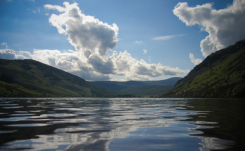
Lough Dan
Lough Dan is a boomerang-shaped ribbon lake near Roundwood, County Wicklow, Ireland. It is a popular area for hikers and kayakers and lies very close to the Wicklow Way. The Inchavore river flows into Lough Dan from the west and Lough Tay feeds it via the Cloghoge river from the north. It is drained to the south by the Avonmore. Most of the lake is surrounded by private lands, though the northwest corner is part of the Wicklow National Park.
Located at 53.08 -6.29 (Lat./Long.); Less than 4 km away
Pictures
Related Locations
Information of geographic nature is based on public data provided by geonames.org, CIA world facts book, Unesco, DBpedia and wikipedia. Weather is based on NOAA GFS.