
Discover Tiquillaca in Peru
Tiquillaca in the region of Puno is a town located in Peru - some 527 mi or ( 848 km ) South-East of Lima , the country's capital .
Local time in Tiquillaca is now 05:21 AM (Wednesday) . The local timezone is named " America/Lima " with a UTC offset of -5 hours. Depending on your flexibility, these larger cities might be interesting for you: Arica, Oruro, La Paz, Ylpa, and Umayo. When in this area, you might want to check out Arica . We found some clip posted online . Scroll down to see the most favourite one or select the video collection in the navigation. Are you looking for some initial hints on what might be interesting in Tiquillaca ? We have collected some references on our attractions page.
Videos
2012 HD Pérou 7 Colca Puno
Etape 7 du parcours au Pérou. Vallée de colca à Puno en passant par la lagune de Lagunillas, lac à 4100 m, donc plus haut que le Titicaca, mais pas suffisamment navigable. Puis Juliaca, ville de la co ..
Videos provided by Youtube are under the copyright of their owners.
Interesting facts about this location
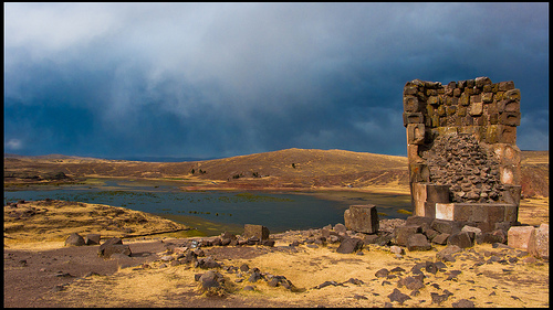
Lake Umayo
Lake Umayo is a lake in the Puno Region of Peru. The shores of the lake house Sillustani burial ground.
Located at -15.74 -70.19 (Lat./Long.); Less than 8 km away
Puno Cathedral
The Catedral Basílica San Carlos Borromeo or Puno Cathedral is an Andean Baroque cathedral in the city of Puno in south-eastern Peru. It is the seat of the Roman Catholic Diocese of Puno. The church was built in 1757.
Located at -15.84 -70.03 (Lat./Long.); Less than 18 km away
Waru Warn
Waru Warn or Waru Waru is an agricultural technique developed by pre hispanic peoples in the Andes region of South America, from Colombia to Bolivia. It is dated around 300 B.C. The technique has been revived in 1984, in Tiawanaco, Bolivia, and Puno, Peru. The technique consists in combining raised beds with irrigation channels so as to prevent damage due to soil erosion during floods.
Located at -15.78 -70.03 (Lat./Long.); Less than 19 km away
Puno
Puno is a city in southeastern Peru, located on the shore of Lake Titicaca. It is the capital city of the Puno Region and the Puno Province with a population of approximately 100,000. The city was established in 1668 by viceroy Pedro Antonio Fernández de Castro as capital of the province of Paucarcolla with the name San Juan Bautista de Puno. The name was later changed to San Carlos de Puno, in honor of king Charles II of Spain.
Located at -15.84 -70.02 (Lat./Long.); Less than 19 km away
Puno Province
Puno is a province in the Puno Region, in southeastern Peru. It borders the provinces of Huancane, San Román, El Collao and the Moquegua Region's province of General Sánchez Cerro. Its capital is the city of Puno, which is located at the edge of Lake Titicaca, the world's highest navigable lake. This province is the economic powerhouse of the region.
Located at -15.84 -70.02 (Lat./Long.); Less than 19 km away
Pictures
Related Locations
Information of geographic nature is based on public data provided by geonames.org, CIA world facts book, Unesco, DBpedia and wikipedia. Weather is based on NOAA GFS.