-
You are here:
- Homepage » South Georgia and the South Sandwich Islands
South Georgia and the South Sandwich Islands Country Guide
Explore South Georgia and the South Sandwich Islands in Antarctica
South Georgia and the South Sandwich Islands with the capital city Grytviken is located in Antarctica . It covers some 3,903 square kilometres with 100 citizens.
The terrain features . The average density of population is approximately 0 per km². The notable climate conditions in South Georgia and the South Sandwich Islands can be described as . Potential natural disasters are .
To reach someone in South Georgia and the South Sandwich Islands dial prior to a number. There are 0 installed telephones. And there are 0 registered mobile phones. The cellular networks commonly support frequencies of MHz. Websites registered in this country end with the top level domain ".gs". If you want to bring electric equipment on your trip (e.g. laptop power supply), note the local power outlet of .
About the flag and history of South Georgia and the South Sandwich Islands
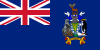
Blue, with the flag of the UK in the upper hoist-side quadrant and the South Georgia and South Sandwich Islands coat of arms centered on the outer half of the flag; the coat of arms features a shield with a golden lion rampant, holding a torch; the shield is supported by a fur seal on the left and a Macaroni penguin on the right; a reindeer appears above the crest, and below the shield on a scroll is the motto LEO TERRAM PROPRIAM PROTEGAT (Let the Lion Protect its Own Land)); the lion with the torch represents the UK and discovery; the background of the shield, blue and white estoiles, are found in the coat of arms of James Cook, discoverer of the islands; all the outer supporting animals represented are native to the islands.
The islands, which have large bird and seal populations, lie approximately 1,000 km east of the Falkland Islands and have been under British administration since 1908 - except for a brief period in 1982 when Argentina occupied them. Grytviken, on South Georgia, was a 19th and early 20th century whaling station. Famed explorer Ernest SHACKLETON stopped there in 1914 en route to his ill-fated attempt to cross Antarctica on foot. He returned some 20 months later with a few companions in a small boat and arranged a successful rescue for the rest of his crew, stranded off the Antarctic Peninsula. He died in 1922 on a subsequent expedition and is buried in Grytviken. Today, the station houses scientists from the British Antarctic Survey. Recognizing the importance of preserving the marine stocks in adjacent waters, the UK, in 1993, extended the exclusive fishing zone from 12 nm to 200 nm around each island.
Geography Quick-Facts
| Summary | Continent: Antarctica Neighbours: Capital: Grytviken |
| Size | 3,903 square kilometers (km² or sqkm) or 1,506 square miles (mi² or sqmi) |
| Population | 100 |
| Currency | Name Pound, Currency Code:GBP |
| Country Top Level Domain (cTLD) | .gs |
| Telephone Country Prefix | |
| Mobile Phone Connections | 0 |
| Landline Phone Connections | 0 |
Country Position in World Rankings
Information about single country attributes and how these compare against the rest of the world. The information below is compiled with data from 2013. As such, it may differ a bit to the Information above in the text (which is from 2010).
Geography
| Value name | Value | World Rank |
|---|---|---|
| Area | 3,903 (sq km) | 177 |
Communications
| Value name | Value | World Rank |
|---|---|---|
| Internet hosts | 470 | 184 |
Data based on CIA facts book 2010 & 2013, wikipedia, national statistical offices and their census releases