-
You are here:
- Homepage »
- France »
- Midi-Pyrenees » Pierrefitte-Nestalas

Pierrefitte-Nestalas Destination Guide
Explore Pierrefitte-Nestalas in France
Pierrefitte-Nestalas in the region of Midi-Pyrénées with its 1,314 inhabitants is a town in France - some 423 mi or ( 681 km ) South of Paris , the country's capital city .
Current time in Pierrefitte-Nestalas is now 10:53 AM (Sunday) . The local timezone is named " Europe/Paris " with a UTC offset of 1 hours. Depending on the availability of means of transportation, these more prominent locations might be interesting for you: Tarbes, Saint-Pe-de-Bigorre, Prechac, Pau, and Luz-Saint-Sauveur. Since you are here already, make sure to check out Tarbes . We encountered some video on the web . Scroll down to see the most favourite one or select the video collection in the navigation. Where to go and what to see in Pierrefitte-Nestalas ? We have collected some references on our attractions page.
Videos
Le Donjon des Aigles (Lourdes Pirineos-4ªParte)
Castillo en el que principalmente se pueden admirar aves rapaces. Animales creados por Dios para disfrutar y cuidar de ellos ..
Le Val d'Azun d'Argelès Gazost à Arrens Marsous
Le Val d'Azun est une magnifique vallée des Pyrénées dont l'axe principal va d'Argelès Gazost à Arrens Marsous. Vous allez traverser les villages de Arras en Lavedan, Aucun, Marsous et Arrens ..
Bungee jump - Napoleon bridge 90m
Bungee jumping - Napoleon bridge, Luz Saint Sauveur - August 2009 ..
Des loisirs hors saison
www.lavedan.com Le camping du LAVEDAN vous réserve mille et une surprises pour vos loisirs. Ici, même en dehors des mois de Juillet et Août, de nombreuses activités sont proposées. Souvent orientées v ..
Videos provided by Youtube are under the copyright of their owners.
Interesting facts about this location
Hautacam
Hautacam is a ski resort in the Pyrenees. It is situated in the Hautes-Pyrénées department, in the Midi-Pyrénées region. The winter sports station lies at a height of 1560 meters. In road bicycle racing, the ascent to Hautacam is known as a tough climb, featuring many times in the Tour de France.
Located at 42.97 -0.01 (Lat./Long.); Less than 5 km away
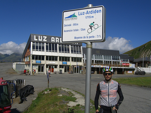
Luz Ardiden
Luz Ardiden is a ski resort in the Pyrenees. It is situated in the Hautes-Pyrénées department, in the Midi-Pyrénées. The ski resort, which lies at a height of 1720 meters, opened on January 16, 1975. In more recent times, the road to Luz Ardiden has served as an occasional stage finish in Tour de France.
Located at 42.89 -0.06 (Lat./Long.); Less than 9 km away
Lac d'Ourrec
Lac d'Ourrec is a lake in Hautes-Pyrénées, France.
Located at 42.95 0.04 (Lat./Long.); Less than 9 km away
Funiculaire du Pic du Jer
The Funiculaire du Pic du Jer, or Pic du Jer Funicular, is a funicular railway in the French département of Hautes-Pyrénées. It links the pilgrimage town of Lourdes with the summit of the nearby Pic du Jer. The funicular was constructed in 1900. The funicular has the following technical parameters: Length: 1100 metres Height: 473 metres Maximum steepness: 56 % Configuration: Single track with passing loop Journey time: 15 minutes Capacity: 80 passengers per car
Located at 43.08 -0.04 (Lat./Long.); Less than 13 km away
Pont d'Espagne
Pont d'Espagne is a stone-built bridge that spans the Gave de Marcadau at the point where it meets the Gave de Gaube, near one of its sources high in the French Pyrenees. The Pont d'Espagne is at an altitude of approx 1500m. The name translates as Spanish Bridge. Google Satellite Map There is a car park nearby and it is possible to get to Lac de Gaube by ski lift. The nearest towns are Cauterets and Lourdes.
Located at 42.85 -0.14 (Lat./Long.); Less than 14 km away
Pictures
Historical Weather
Related Locations
Information of geographic nature is based on public data provided by geonames.org, CIA world facts book, Unesco, DBpedia and wikipedia. Weather is based on NOAA GFS.