-
You are here:
- Homepage »
- United Kingdom »
- England » Handley

Handley Destination Guide
Discover Handley in United Kingdom
Handley in the region of England is a place located in United Kingdom - some 90 mi or ( 145 km ) South-West of London , the country's capital .
Local time in Handley is now 02:29 AM (Wednesday) . The local timezone is named " Europe/London " with a UTC offset of 0 hours. Depending on your mobility, these larger cities might be interesting for you: Witchampton, Tollard Royal, Three Legged Cross, Southampton, and Reading. When in this area, you might want to check out Witchampton . We discovered some clip posted online . Scroll down to see the most favourite one or select the video collection in the navigation. Are you looking for some initial hints on what might be interesting in Handley ? We have collected some references on our attractions page.
Videos
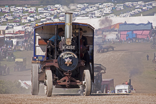
The Great Dorset Steam Fair 2010 Heavy Haulage
The various Heavy Haulage loads in the Play Pen at The Great Dorset Steam Fair 2010; 1925 Burrell D Class Traction Engine No.4019 Britannia hauling the stone block 1922 Burrell Road Locomotive No.3937 ..
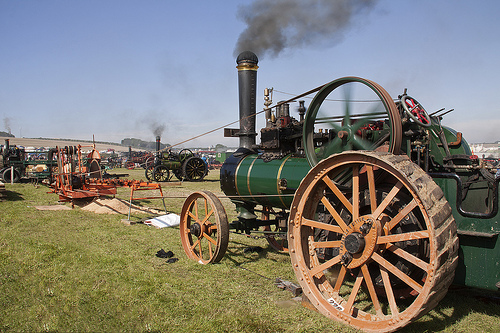
Great Dorset Steam Fair 2010
A sunny show this year - hence all the dust! ..
The Great Dorset Steam Fair 2010
This is a short film using clips collected at The Great Dorset Steam Fair 2010. We were there from Thursday night to Sunday morning, and collected around 40minutes of footage, all cut up and thrown in ..
The Watercress Line
Part of a footplate trip on Standard Class 5 4-6-0 No. 73096 with a trainee fireman under instruction ..
Videos provided by Youtube are under the copyright of their owners.
Interesting facts about this location
Sixpenny Handley Hundred
Sixpenny Handley Hundred was a hundred in the county of Dorset, England. It originally consisted of two distinct hundreds: Sexpena and Hanlega. Sometime around the 14th century, the two hundreds were united as the hundred of "Sexpenne et Henle". Sixpenny Handley Hundred contained the following parishes: Cann Compton Abbas East Orchard Fontmell Magna Iwerne Minster Melbury Abbas Sixpenny Handley (originally known as just Handley) West Orchard
Located at 50.95 -2.00 (Lat./Long.); Less than 0 km away
Dorset Cursus
The Dorset Cursus is a Neolithic cursus monument that spans across 10 km (6¼ miles) of the chalk downland of Cranborne Chase in east Dorset, United Kingdom. Its extreme length makes it a notable example of this class of linear earthwork; it is better interpreted as a pair of same-length cursus constructed end to end, with the more southerly cursus (the Gussage Cursus) pre-dating the northerly one (the Pentridge Cursus).
Located at 50.94 -1.98 (Lat./Long.); Less than 2 km away
Cranborne Chase
Cranborne Chase is a chalk plateau in central southern England, straddling the counties Dorset, Hampshire and Wiltshire. The plateau is part of the English Chalk Formation and is adjacent to Salisbury Plain and the West Wiltshire Downs in the north, and the Dorset Downs to the south west. The scarp slope of the hills faces the Blackmore Vale to the west, and to some extent the Vale of Wardour to the north. The chalk gently slopes south and dips under clays and gravels.
Located at 50.96 -2.04 (Lat./Long.); Less than 3 km away
Bokerley Dyke
Bokerley Dyke (or Bokerley Ditch) is a Romano-British defensive dyke 3.25 miles long in north east Dorset, England, near the villages of Woodyates and Pentridge. Bokerley Dyke may have originated in the Bronze Age or Early Iron Age and formed a political and cultural boundary. It was cut through by a Roman Road in the 1st century. In the 4th century it was remodelled and bought back into use, and excavations show that the Roman road was blocked.
Located at 50.97 -1.94 (Lat./Long.); Less than 5 km away
Wimborne St Giles Hundred
Wimborne St Giles Hundred was a hundred in the county of Dorset, England, containing the following parishes: Wimborne All Saints (absorbed by Wimborne St Giles 1732) Wimborne St Giles West Woodyates (created 1858)
Located at 50.92 -1.95 (Lat./Long.); Less than 5 km away
Pictures

Related Locations
Information of geographic nature is based on public data provided by geonames.org, CIA world facts book, Unesco, DBpedia and wikipedia. Weather is based on NOAA GFS.