-
You are here:
- Homepage »
- United States »
- Oregon » Brownsville

Brownsville Destination Guide
Discover Brownsville in United States
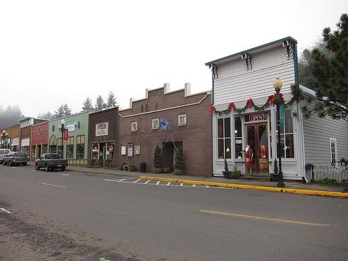
Brownsville in the region of Oregon with its 1,668 habitants is a town located in United States - some 2,371 mi or ( 3816 km ) West of Washington , the country's capital .
Local time in Brownsville is now 02:22 PM (Saturday) . The local timezone is named " America/Los Angeles " with a UTC offset of -7 hours. Depending on your flexibility, these larger cities might be interesting for you: Waterloo, Corvallis, Crawfordsville, Crowfoot, and Eugene. When in this area, you might want to check out Waterloo . We found some clip posted online . Scroll down to see the most favourite one or select the video collection in the navigation. Are you looking for some initial hints on what might be interesting in Brownsville ? We have collected some references on our attractions page.
Videos
Grand Theft Auto Vice City: The King of Vigilante
hunter owns everthing ..
Brownsville Oregon Stand by me Locations
LB Productions has captured this quaint little town of 1700 residences called Brownsville, Oregon. Home of the Movie "Stand By Me" Scott Smith Location scout. ..
redroom premiere for gallery oregon tour vid
premiere date set for the 13th of oct at the redroom in longbeach ca. come rage with us! ..
Montival Tour - Western Oregon - Emberverse Part 2
Tour of key points from SM Stirling's Emberverse (aka The Change) series of fictional novels - Part 2 - Brownsville, Dun Juniper ..
Videos provided by Youtube are under the copyright of their owners.
Interesting facts about this location
Showa Airport
Showa Airport is a private Airport located 2 miles west of Brownsville in Linn County, Oregon, USA.
Located at 44.39 -123.03 (Lat./Long.); Less than 4 km away
Cubehole Airport
Cubehole Airport is a private Airport located 2 miles Southeast of Brownsville in Linn County, Oregon, USA.
Located at 44.36 -122.96 (Lat./Long.); Less than 4 km away
Central Linn High School
Central Linn High School is a public high school in Halsey, Oregon, United States.
Located at 44.39 -123.09 (Lat./Long.); Less than 8 km away
Lafferty Field
Lafferty Field is a private airport located 5 miles south of Brownsville in Linn County, Oregon, USA.
Located at 44.32 -123.03 (Lat./Long.); Less than 9 km away
Boston Flour Mill
Boston Flour Mill is a historic gristmill in Shedd, Oregon. It was built in 1863 and added to the National Register of Historic Places in 1979. It is part of the Thompson's Mills State Heritage Site. The mill has been the site of field schools of both the historic preservation program and the archaeology program of the University of Oregon, in 2003 and 2005 respectively.
Located at 44.46 -123.08 (Lat./Long.); Less than 11 km away
Pictures
Related Locations
Information of geographic nature is based on public data provided by geonames.org, CIA world facts book, Unesco, DBpedia and wikipedia. Weather is based on NOAA GFS.