-
You are here:
- Homepage »
- Australia »
- New South Wales » Blackheath

Blackheath Destination Guide
Delve into Blackheath in Australia
Blackheath in the region of New South Wales with its 4,178 residents is located in Australia - some 132 mi or ( 212 km ) North-East of Canberra , the country's capital .
Local time in Blackheath is now 04:50 PM (Wednesday) . The local timezone is named " Australia/Sydney " with a UTC offset of 11 hours. Depending on your mobility, these larger destinations might be interesting for you: Wentworth Falls, Sydney City, Mount Wilson, Megalong, and Lithgow. While being here, you might want to check out Wentworth Falls . We discovered some clip posted online . Scroll down to see the most favourite one or select the video collection in the navigation. Are you curious about the possible sightseeing spots and facts in Blackheath ? We have collected some references on our attractions page.
Videos
The Boys From Blackheath Airstrip Bike Track Taking Off! (First cut) Check out our second version!
The boys are about to be evicted by Blue Mountains City Council from this dirt bike track. They will be moved to a dangerous and unsuitable site further out of town. Sign our petition to save this are ..
Snow Blackheath NSW Australia June 21st 2011
Snow during the afternoon of June 21st, 2011. Blackheath, NSW Australia on our roadtrip from Brisbane Queensland, Australia to Sydney. The boys first snow. I hadn't seen snow in 12 years. We made 2 sn ..
Mountain devil and other flowers in Australia
Broadcast format available at: www.stockshot.nl Australian flora in the Blue Mountains. Blackheath, evans lookout, anvil rock, mountain devil. ..
The Boys From Blackheath Airstrip Bike Track Taking Off!
These Guys are about to be evicted from their bike track by Blue Mountains City Council. It's been here for 3 generations. Help save this track and surrounding bushland by signing this petition. www.g ..
Videos provided by Youtube are under the copyright of their owners.
Interesting facts about this location
Blackheath, New South Wales
Blackheath (elevation 1065 metres) is a town located near the top of the Blue Mountains in New South Wales, Australia, 120 kilometres west north-west of Sydney, 11 kilometres north-west of Katoomba and 30 kilometres south-east of Lithgow. In 2006, Blackheath had a population of 4,177 people.
Located at -33.63 150.29 (Lat./Long.); Less than 1 km away
Medlow Bath, New South Wales
Medlow Bath is an Australian small town located near the highest point of the Blue Mountains, between Katoomba and Blackheath. It has an approximate altitude of 1050 m and is located approximately 115 kilometres west north west of Sydney and 5 kilometres north west of Katoomba. At the 2006 census, Medlow Bath had a population of 461 people.
Located at -33.67 150.28 (Lat./Long.); Less than 4 km away
Evans Lookout
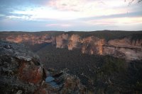
Evans Lookout is a lookout in the Blue Mountains, New South Wales, Australia. Overlooking the sandstone cliffs of the Grose River Valley, the lookout is also an access point for pedestrian access to the valley floor. Nearby walks include the Grand Canyon and trails to Govetts Leap lookout. A popular, easily accessible location, the lookout is located within the Blue Mountains National Park close to the town of Blackheath.
Located at -33.65 150.32 (Lat./Long.); Less than 4 km away
Medlow Bath railway station
Medlow Bath railway station is a regional railway station on the Blue Mountains Line of the CityRail intercity network, serving the town of Medlow Bath in the Upper Blue Mountains in New South Wales, Australia. The station opened in 1880. The station has an island platform and is served by one train each way every two hours in off-peak, with additional services during peak hours.
Located at -33.67 150.28 (Lat./Long.); Less than 4 km away
Grose Valley
The Grose Valley is a rugged valley in the Blue Mountains, New South Wales, Australia. It has been formed by the Grose River, the headwaters of which are in the Mount Victoria area. The valley is located between the Great Western Highway and Bells Line of Road, the two major routes across the Blue Mountains. The majority of the valley falls within the Blue Mountains National Park.
Located at -33.60 150.34 (Lat./Long.); Less than 7 km away
Pictures
Historical Weather
Related Locations
Information of geographic nature is based on public data provided by geonames.org, CIA world facts book, Unesco, DBpedia and wikipedia. Weather is based on NOAA GFS.

