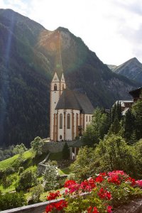
Explore Heiligenblut in Austria
Heiligenblut in the region of Carinthia is a town in Austria - some 183 mi or ( 295 km ) South-West of Vienna , the country's capital city .
Current time in Heiligenblut is now 10:17 AM (Friday) . The local timezone is named " Europe/Vienna " with a UTC offset of 1 hours. Depending on the availability of means of transportation, these more prominent locations might be interesting for you: Jorgnalm, Zell am See, Worth, Wels, and Villach. Since you are here already, make sure to check out Jorgnalm . We encountered some video on the web . Scroll down to see the most favourite one or select the video collection in the navigation. Where to go and what to see in Heiligenblut ? We have collected some references on our attractions page.
Videos
Triumph tiger 1050 austria Strada alpina del Grossglockner Großglockner
Viaggio in moto con la mitica Triumph Tiger 1050 sulla strada alpina del Großglockner ..
Grossglockner-Hochalpenstrasse (Teil 2/5)
Die Strasse von Heiligenblut Kreisl bis Hochtor - der höchste Punkt der Strasse. ..
Heiligenblut
Heiligenblut is an Austrian village in the province of Carinthia. It is situated in the Hohe Tauern mountain ridge on an altitude of 1288 mtrs. The village is well known because it is the southern sta ..
Grossglocknerstrasse 2008 Edelweiss-Spitze 2571m npm
Malina,Maciej-BMW R1100R Magda, Przemo-Honda CBF 600 ..
Videos provided by Youtube are under the copyright of their owners.
Interesting facts about this location
Stausee Margaritze
Stausee Margaritze is a lake of Carinthia, Austria.
Located at 47.07 12.77 (Lat./Long.); Less than 7 km away
Pasterze Glacier
The Pasterze, at approximately 8.4 kilometers (5.2 mi) in length, is the longest glacier in Austria and in the Eastern Alps reaching from the 3,453-metre Johannisberg to 2,100 metres above sea level. It lies within the Hohe Tauern mountain range in Carinthia, directly beneath Austria's highest mountain, the Grossglockner. The Pasterze can be reached via the Grossglockner High Alpine Road and a funicular railway. The length of the glacier currently decreases about 10 m (33 ft) each year.
Located at 47.09 12.72 (Lat./Long.); Less than 10 km away
Wangenitzsee
Wangenitzsee is a lake of Carinthia, Austria, {{#invoke:Coordinates|coord}}{{#coordinates:46|55|37|N|12|48|01|E| | |name= }}.
Located at 46.93 12.80 (Lat./Long.); Less than 13 km away
Großes Wiesbachhorn
The Großes Wiesbachhorn (3,564 m) is a mountain in the federal state of Salzburg, Austria and, at 3,564 m AA (according to other sources 3,570 m AA), is the third-highest peak of the Hohe Tauern range. Ita entirely free-standing firn-capped summit forms the main peak of the Fusch/Kaprun chain and is often viewed in Alpine literature as a rival of the Großglockner.
Located at 47.16 12.76 (Lat./Long.); Less than 15 km away
Glacial Aerial Tramway Kaprun III
The Glacial Aerial Tramway Kaprun III (Gletscherbahn Kaprun III) is the third section of the aerial tramway on the Kitzsteinhorn mountain at Kaprun, Austria. It was placed in service on 26 November 1966. The tramway was built by the companies Elin, Waagner Biro, Swoboda. It has two cabins with a capacity of 60 persons, running from the station Krefelder Hut (Krefelder Hütte) which is 2453 metres above the sea level to the station Kitzsteinhorn at 3029 metres.
Located at 47.21 12.69 (Lat./Long.); Less than 22 km away
Pictures
Historical Weather
Related Locations
Information of geographic nature is based on public data provided by geonames.org, CIA world facts book, Unesco, DBpedia and wikipedia. Weather is based on NOAA GFS.


