
Discover Rinn in Austria
Rinn in the region of Tyrol is a place located in Austria - some 236 mi or ( 380 km ) West of Vienna , the country's capital .
Local time in Rinn is now 10:42 PM (Thursday) . The local timezone is named " Europe/Vienna " with a UTC offset of 1 hours. Depending on your mobility, these larger cities might be interesting for you: Weer, Wattens, Tulfes, Hall in Tirol, and Schoenberg im Stubaital. When in this area, you might want to check out Weer . We discovered some clip posted online . Scroll down to see the most favourite one or select the video collection in the navigation. Are you looking for some initial hints on what might be interesting in Rinn ? We have collected some references on our attractions page.
Videos
Visual Approach to Innsbruck B737-500 SkyEurope Cockpit View
Visual approach to INN airport. Video speed 2x ..
time-lapse: nightfall over innsbruck, austria
time-lapse video of innsbruck, between sunset to darkness 2 hours, 15 second interval. soundtrack: tim minchin - not perfect ( www.youtube.com ) more information: www.thinkoholic.com ..
Tulfes in der Region Hall-Wattens Tirol Österreich
www.hall-wattens.at Das hübsche Dorf Tulfes in der Region Hall-Wattens bezaubert vor allem durch seine sonnige Lage auf einem einladenden Plateau über dem Inntal. Tulfes ist ein wahres Freizeitparadie ..
4* Austria Classic Hotel Heiligkreuz, Hall in Tirol
4* Austria Classic Hotel Heiligkreuz www.kurz-mal-weg.at ..
Videos provided by Youtube are under the copyright of their owners.
Interesting facts about this location
Lanser Bach
The Lanserbach - also called Mühlbach - flows from Lans alongside the Paschberg to Aldrans and merges with the Inn river after 17 km at the eastern edge of Innsbruck. Below Castle Ambras the Aldranser brook joins the Lanserbach. The brook has a meander-like headwater and fed "Lake Mühl" with fresh water formerly. The brook has grade A- quality and supplies Aldrans and environment with drinking water by a service reservoir in the village. Normally the waters are relatively calm.
Located at 47.27 11.46 (Lat./Long.); Less than 4 km away
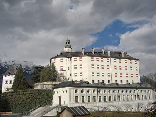
Hasegg Castle
Hasegg Castle is a castle and mint located in Hall in Tirol, Tyrol, Austria. Construction was completed soon after 1300, when Hall was rapidly becoming the center of Tyrolean commerce and salt mining. The building was originally erected to protect the salt mines, the shipping industry, the bridge across the river Inn and the old Roman Road. The castle's mint was established by Sigismund, Archduke of Austria in 1477. The first dollar-size silver coin was struck in 1486: the Guldengroschen.
Located at 47.28 11.50 (Lat./Long.); Less than 4 km away
Baggersee Innsbruck
Baggersee Innsbruck is located in the south-eastern part of Innsbruck at the Inn River and belongs to the city district Amras. With an area size of 2.8 ha it is the second largest lake in the city area. Only the Lake Lans surpasses it by size and volume. Many people use the lake as recreation area in Summer. The water can warm up to 24 °C. Recreational activities at the lake include beach volley, badminton, streetball or table tennis. In fall the water is intensively used for surfing.
Located at 47.27 11.45 (Lat./Long.); Less than 4 km away
Innsbruck bypass
|} The Innsbruck bypass is a 14.853 kilometre-long double-track electrified main line of the Austrian railways. It connects the Lower Inn Valley railway with the Brenner railway, bypassing Innsbruck. It was opened on 29 May 1994. The line is at a major part of the rail freight network of Austrian Federal Railways (ÖBB). The bypass is part of the Line 1 of Trans-European Transport Networks (TEN-T).
Located at 47.28 11.54 (Lat./Long.); Less than 5 km away
Aldranser Bach
The Aldranser Bach is a small stream near Innsbruck, Austria. It has its source near Aldrans amidst the forest and flows in northern direction to Castle Ambras. Above the castle were a swimming pool for the public which was formerly fed by the Aldranserbach. In the big garden of the Castle the brook supplies the Great Pond with fresh water and then flows further through the Forest Park to Ambras, where it merges with the Lanser Bach and then further into the Inn River.
Located at 47.26 11.44 (Lat./Long.); Less than 5 km away
Pictures
Historical Weather
Related Locations
Information of geographic nature is based on public data provided by geonames.org, CIA world facts book, Unesco, DBpedia and wikipedia. Weather is based on NOAA GFS.