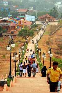
Delve into Malappuram in India
Malappuram in the region of Kerala with its 61,743 residents is a city in India - some 1,216 mi or ( 1957 km ) South of New Delhi , the country's capital .
Current time in Malappuram is now 03:22 AM (Thursday) . The local timezone is named " Asia/Kolkata " with a UTC offset of 5.5 hours. Depending on your travel modalities, these larger destinations might be interesting for you: Valiyora, Thiruvananthapuram, Trikkalangod, Thrissur, and Tirurangadi. While being here, make sure to check out Valiyora . We encountered some video on the web . Scroll down to see the most favourite one or select the video collection in the navigation. Are you curious about the possible sightseeing spots and facts in Malappuram ? We have collected some references on our attractions page.
Videos
Soulja Boy-Blowing Me Kisses COVER with Autotune
This is soulja boy's blowing me kisses sung by me. The song is created with autotune in fl studio 9. Hope you like it! Soulja boy Blowing me kisses Lyrics: Yeah, I said this one for your stereo Turn m ..
Egyptian Dance - Malappuram Craft Mela Dec. 2010
..
Malabar Flower Show @ Kottakkunnu
Malabar Flower Show @ Kottakkunnu - Malappuram, Video by Mehaboob Valanchery, Uploaded by Thahir Valanchery. ..
Lollipop Kids & Ladies Exclusive Kottakkal
Lollipop A leading exclusive kids n ladies wears in kottakkal..its own your World..... by Noushad (BiG FuN) Kuttippala ..
Videos provided by Youtube are under the copyright of their owners.
Interesting facts about this location
Malabar Rebellion
The Malabar Rebellion (also known as the "Moplah Rebellion", "മാപ്പിള ലഹള" Māppila Lahaḷa in Malayalam) was an armed uprising in 1921 against British authority and Hindus in the Malabar region of Southern India by Mappila Muslims and the culmination of a series of Mappila revolts that recurred throughout the 19th century and early 20th century.
Located at 11.07 76.07 (Lat./Long.); Less than 0 km away
Manjeri
Manjeri is a town and municipality in Malappuram District in the state of Kerala, India, with a population of 83,707 inhabitants at the 2001 Census. It is situated 12 km from Malappuram and 45 km from Calicut railway station. Manjeri was a centre of Indian nationalist movements. Nellikuth, 6 km from Manjeri was one of the major center of the Malabar Rebellion of 1921. Nellikuth is the birthplace of Ali Musliyar, the rebel leader. Anti-British revolts tool place in 1790 in and around Manjeri.
Located at 11.12 76.12 (Lat./Long.); Less than 8 km away
Nusrathul Islam Madrasa
Nusrathul Islam Madrasa is a Madrasa (an Islamic religious school) situated in Pullancheri, Manjeri, Kerala, India. This is an institution which gives Islamic religious education alongside conventional education. Nusrathul Islam Madrasa is affiliated to Samastha Kerala Islam Matha Vidyabhyasa Board . This Madrassa is equivalent to a secondary school in the conventional schooling, and hence hosts classes for grade 1 through 10.
Located at 11.10 76.15 (Lat./Long.); Less than 9 km away
Pullancheri
Pullancheri is a location at Manjeri of Kerala state of India, with hills and one river named Kadalundy River. Pullancheri is situated 5 kilometres away from Manjeri. This area is the 27th Ward of Manjeri Municipality. This place is situated at the east of Manjeri town. East side of Pullancheri is Nellikkuth and Pandikkad. South is Anakkayam and north is Payyanad. Pullancheri is 5 km far from Manjeri town.
Located at 11.10 76.15 (Lat./Long.); Less than 10 km away
Nilgiris district
The Nilgiris District is in the Indian state of Tamil Nadu. Nilgiri (English: Blue Mountains) is also the name given to a range of mountains spread across the states of Tamilnadu as well as Karnataka and Kerala. The Nilgiri Hills are part of a larger mountain chain known as the Western Ghats. The highest point is the mountain of Doddabetta, with a height of 2,623 m. The district is mainly contained within this mountain range. The district headquarters is Ooty.
Located at 11.00 76.13 (Lat./Long.); Less than 10 km away
Pictures
Historical Weather
Related Locations
Information of geographic nature is based on public data provided by geonames.org, CIA world facts book, Unesco, DBpedia and wikipedia. Weather is based on NOAA GFS.


