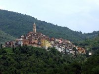
Delve into Isolabona in Italy
Isolabona in the region of Liguria with its 643 residents is located in Italy - some 281 mi or ( 452 km ) North-West of Rome , the country's capital .
Local time in Isolabona is now 05:17 AM (Tuesday) . The local timezone is named " Europe/Rome " with a UTC offset of 1 hours. Depending on your mobility, these larger destinations might be interesting for you: Nice, Menton, Grasse, Draguignan, and Briançon. While being here, you might want to check out Nice . We discovered some clip posted online . Scroll down to see the most favourite one or select the video collection in the navigation. Are you curious about the possible sightseeing spots and facts in Isolabona ? We have collected some references on our attractions page.
Videos
Agriturismo Al Pagan - Pigna (Im)
Incorniciato da boschi ed oliveti, l'Agriturismo "Al Pagan" è situato nel cuore della Val Nervia a breve distanza dal percorso dell'Alta Via dei Monti Liguri e gode di una splendida vista sui massicci ..
Pigna Terme - Bordighera -Imperia - Riviera dei Fiori Val Nervia
Pigna le Terme, nell'entroterra di Bordighera Ventimiglia, poco sopra Dolceacqua, completamente nuove e con importanti caratteristiche curative. tel.0039 0184 484236/7 www.mariemontiliguri.eu http ..
Summer Cruise 2010 - Vol. 5
Video von summercruise2010 ..
Castelvittorio Imperia - Riviera dei Fiori Val Nervia
Immagini di castel Vittorio sopra Pigna in alta Val Nervia, riprese lungo la la Strada che collega Pigna a Colle Langan verso la Valle Argentina. Siamo nell'entroterra di Bordighera, Ventimiglia, Sanr ..
Videos provided by Youtube are under the copyright of their owners.
Interesting facts about this location
Principality of Seborga
The Principality of Seborga is a self-proclaimed micronation located in the northwestern Italian Province of Imperia in Liguria, near the French border, and in sight of Monaco. The principality is in coexistence with, and claims the territory of, the town of Seborga, which is an Italian municipality.
Located at 43.83 7.69 (Lat./Long.); Less than 7 km away
Bévéra
The Bévéra or Bevera is a river of southeastern France and northwestern Italy. Its source is in the Maritime Alps, near Moulinet in the French Alpes-Maritimes department. It flows generally southeast, through Sospel, crosses the Italian border and discharges into the river Roya, near Ventimiglia. Its length within France is 27 km.
Located at 43.82 7.58 (Lat./Long.); Less than 8 km away
Ventimiglia railway station
Ventimiglia railway station (Italian: Stazione di Ventimiglia) is the main station of the Italian city of Ventimiglia. It is at the end of three rail routes: the Genoa–Ventimiglia line, the Cuneo–Ventimiglia line and the Marseille–Ventimiglia line. It plays an important role not only in rail transport in Liguria, but also in Italy. Despite being an important station, it is in some disrepair. The station is currently managed by Rete Ferroviaria Italiana (RFI).
Located at 43.79 7.61 (Lat./Long.); Less than 10 km away
Roya (river)
The Roya, Roia, or Ròia is a 59 km river of France and Italy. The river rises in French territory near the Col de Tende and flows through the Mercantour National Park The river passes through the communes of Tende, Saorge, Breil-sur-Roya, La Brigue, before entering Italy in the commune of Olivetta San Michele. The remainder of its course remains within the province of Imperia and, after crossing Airole the river enters the sea at Ventimiglia.
Located at 43.79 7.61 (Lat./Long.); Less than 11 km away
Maglia
The Maglia is a river that flows through the Alpes-Maritimes department of southeastern France. It flows into the Roya River near Breil-sur-Roya.
Located at 43.95 7.52 (Lat./Long.); Less than 13 km away
Pictures
Historical Weather
Related Locations
Information of geographic nature is based on public data provided by geonames.org, CIA world facts book, Unesco, DBpedia and wikipedia. Weather is based on NOAA GFS.


