
Delve into Linate in Italy
Linate in the region of Lombardy is a city in Italy - some 293 mi or ( 472 km ) North-West of Rome , the country's capital .
Current time in Linate is now 10:41 PM (Thursday) . The local timezone is named " Europe/Rome " with a UTC offset of 1 hours. Depending on your travel modalities, these larger destinations might be interesting for you: Munich, Vimodrone, Venice, Varedo, and Turin. While being here, make sure to check out Munich . We encountered some video on the web . Scroll down to see the most favourite one or select the video collection in the navigation. Are you curious about the possible sightseeing spots and facts in Linate ? We have collected some references on our attractions page.
Videos
Red Bull Flugtag - Milano Idroscalo - 10/06/2012
..
Landing thru clouds and fog at Milano-Linate general aviation airport
Cockpit view of landing with PIPER PA-31T1 CHEYENNE I at Milano-Linate general aviation aeroport, from sunny sky to foggy airfield in 3 minutes. ..
Milan's 2012 Red Bull Flugtag
Clips from the Red Bull Fulgtag in Milan 2012 ..
Red Bull Flugtag 2012, team CANADAIIII!!! flying into the water, Milan, Italy
Red Bull Flugtag is an event owned and operated by Red Bull in which competitors attempt to fly homemade size (max 10m / 30 ft) and weight (max 150 kg / 330 lbs) limited human-powered flying machines. ..
Videos provided by Youtube are under the copyright of their owners.
Interesting facts about this location
Linate Airport disaster
The Linate Airport disaster occurred on 8 October 2001 at Linate Airport in Milan, Italy, when Scandinavian Airlines Flight 686, a McDonnell Douglas MD-87 airliner carrying 110 people bound for Copenhagen, Denmark, collided on take-off with a Cessna Citation CJ2 business jet carrying four people bound for Paris, France. All 114 people on board the two aircraft were killed, as were four on the ground. A further four people on the ground were injured.
Located at 45.45 9.28 (Lat./Long.); Less than 0 km away
Ponte Lambro (district of Milan)
Ponte Lambro (literally, "Lambro Bridge") is a district of Milan, Italy. It is the outermost part of the Zone 4 administrative division, extending south-east of the city centre. Parco Lambro is a border district, located past the Tangenziale which encircles most of the city. To the east, it borders on Peschiera Borromeo (the border itself being marked by the eponymous Lambro river); to the south, it borders on San Donato Milanese.
Located at 45.44 9.26 (Lat./Long.); Less than 1 km away
Monluè
Monluè is a district of Milan, Italy, part of the Zone 4 administrative division, located east of the city centre. It is a small residential district that originated as a rural settlement. As a consequence of its isolation from the city proper, it has maintained wide green areas (the most notable of which is Monluè Park) and the general appearance of a small country town.
Located at 45.46 9.25 (Lat./Long.); Less than 2 km away
Taliedo
Taliedo is a peripheral district of the city Milan, Italy, part of the Zone 4 administrative division, located south-east of the city centre. The informal boundaries of the district are three main city streets, respectively Via Mecenate, Via Bonfadini and Via Salomone. Taliedo was part of the comune of Corpi Santi, which was annexed to Milan in 1873. The area was mostly rural until the early 20th century. The district is in fact named after a cascina (i.e.
Located at 45.45 9.25 (Lat./Long.); Less than 2 km away
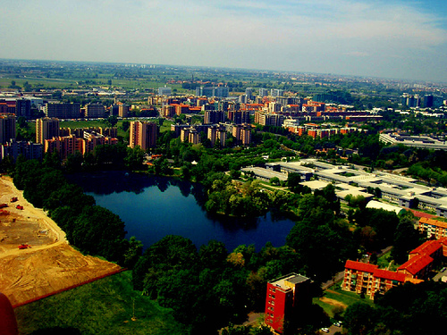
Idroscalo
The Idroscalo is an artificial lake in Milan, Italy that was originally constructed as a seaplane airport. It opened on 28 October 1930, in the heyday of seaplanes. When the use of seaplanes for passenger transport declined it became a recreational and sport facility. The lake is 2,600 m long and was constructed in the late 1920s. Its width ranges from 250 m to 400 m and depth from 3 m to 5 m .
Located at 45.46 9.29 (Lat./Long.); Less than 2 km away
Pictures
Historical Weather
Related Locations
Information of geographic nature is based on public data provided by geonames.org, CIA world facts book, Unesco, DBpedia and wikipedia. Weather is based on NOAA GFS.