
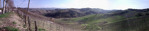
Discover Santa Giuletta in Italy
Santa Giuletta in the region of Lombardy with its 1,615 habitants is a place located in Italy - some 273 mi or ( 439 km ) North-West of Rome , the country's capital .
Local time in Santa Giuletta is now 06:52 PM (Monday) . The local timezone is named " Europe/Rome " with a UTC offset of 1 hours. Depending on your mobility, these larger cities might be interesting for you: Munich, Zinasco, Venice, Turin, and Stradella. When in this area, you might want to check out Munich . We discovered some clip posted online . Scroll down to see the most favourite one or select the video collection in the navigation. Are you looking for some initial hints on what might be interesting in Santa Giuletta ? We have collected some references on our attractions page.
Videos
Cidade ideal?
Sabbioneta representa uma cidade ideal, um projeto urbanístico do 1500 mas que até hoje deveria ser usado como exemplo, a cidade é pequena, tem pouco mais de 4 mil habitantes, seu fundador era extrava ..
tu sei acqua
L'acqua ripulisce e dissolve ogni problematica emotiva, lasciati avvolgere dalle immagini e dalla musica, un senso di benessere pervaderà il tuo corpo, la tua mente e il tuo cuore. ..
Tour du Pelvo d'Elva en Vtt
Belle boucle en 2 jours a Vtt avec la tribu des Vttouriens! ..
Villa Arabella - Bed & Breakfast in the Oltrepo Pavese
Less than an hour from Milan & Geneo, a lovely villa where you can relax by the pool and be introduced to the wines and foody pleasures of the region. ..
Videos provided by Youtube are under the copyright of their owners.
Interesting facts about this location
Battle of Montebello
Located at 45.04 9.24 (Lat./Long.); Less than 4 km away
Clastidium
Clastidium, was a village of the Anamares, in Gallia Cispadana, on the Via Postumia, 5 miles east of Iria and 31 miles west of Placentia. Here in 222 BC, Marcus Claudius Marcellus defeated the Gauls and won the spolia opima; in 218 BC, Hannibal took it and its stores of corn by treachery. It never had an independent government, and not later than 190 BC was made part of the colony of Placentia, founded in 219 BC.
Located at 45.02 9.13 (Lat./Long.); Less than 4 km away
Ticino (river)
The river Ticino is a left-bank tributary of the Po River. It has given its name to the Swiss canton through which its upper portion flows.
Located at 45.15 9.23 (Lat./Long.); Less than 13 km away
Staffora
The Staffora is a river of the Oltrepò Pavese in the Province of Pavia, north-west Italy and a right-side tributary of the Po. It is probably the river known to the Romans as the Iria.
Located at 45.07 9.02 (Lat./Long.); Less than 14 km away
Naviglio Pavese
The Naviglio Pavese is one of the canals making up the Navigli system in Lombardy, Italy. Once navigable, it is 33 km long and connected the city of Milan to Pavia, and through a flight of six locks to the River Ticino. Construction started in 1564, but was interrupted 20 years later just outside Milan due to technical problems: the lock there is still called Conca Fallata, which in Italian means "Failed Lock". Building resumed at the beginning of the 19th century and was completed in 1819.
Located at 45.17 9.17 (Lat./Long.); Less than 15 km away
Pictures
Historical Weather
Related Locations
Information of geographic nature is based on public data provided by geonames.org, CIA world facts book, Unesco, DBpedia and wikipedia. Weather is based on NOAA GFS.