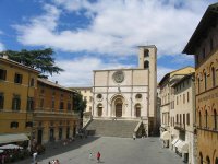
Discover Grutti in Italy
Grutti in the region of Umbria is a town located in Italy - some 66 mi or ( 106 km ) North of Rome , the country's capital .
Local time in Grutti is now 04:47 PM (Wednesday) . The local timezone is named " Europe/Rome " with a UTC offset of 1 hours. Depending on your flexibility, these larger cities might be interesting for you: San Marino, Rome, Rimini, Petroro, and Perugia. When in this area, you might want to check out San Marino . We found some clip posted online . Scroll down to see the most favourite one or select the video collection in the navigation. Are you looking for some initial hints on what might be interesting in Grutti ? We have collected some references on our attractions page.
Videos
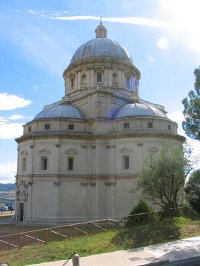
Todi, Italy #20 Chiesa di Santa Maria Della Conssolazione
For more updates follow us on Twitter twitter.com ..
Todi, Italy #30 Agriturismo Borgo Montecucco
For more updates follow us on Twitter twitter.com ..
Chiesa di St Fortunato- Todi, Italy, Davidsbeenhere.ocm
For more updates follow us on Twitter twitter.com ..
Viaggio a Roma (A Trip to Rome): The Arch of Constantine
Father Robert Reed continues his tour of Rome. In this segment he visits the Arch of Constantine, one of the few remaining arches remaining from the Roman Empire that stands just yards from the Coloss ..
Videos provided by Youtube are under the copyright of their owners.
Interesting facts about this location
Azzano (Spoleto)
Azzano is an hamlet in central Umbria, a frazione of Spoleto in the upper floodplain of the Clitunno River, at 229 m above sea-level; its population is about 100. Traces of the ancient Roman Via Flaminia can still be made out near the village, the chief monuments of which are the three medieval churches of S. Maria, S. Paolo, and S. Lorenzo.
Located at 42.82 12.48 (Lat./Long.); Less than 4 km away
Bastardo (Giano dell'Umbria)
Bastardo, a small town in the Italian province of Perugia in central Umbria in the valley of Torrente Puglia, at {{#invoke:Coordinates|coord}}{{#coordinates:42|52|15|N|12|33|35|E|type:city_region:IT_source:nlwiki |primary |name= }}; altitude 290 m (951 ft) above sea-level. It is a village in the commune of Giano dell'Umbria, which is 7 km (about 4 mi) S by road.
Located at 42.87 12.56 (Lat./Long.); Less than 8 km away
Papal States
The Papal States were territories in the Italian peninsula under the sovereign direct rule of the Pope, from the 500s until 1870. They were among the major states of Italy from roughly the sixth century until the Italian peninsula was unified in 1861 by the Kingdom of Piedmont-Sardinia. After 1861 the Papal States, in less territorially extensive form, continued to exist until 1870. At their most extensive they covered most of the modern Italian regions of Romagna, Marche, Umbria and Lazio.
Located at 42.82 12.60 (Lat./Long.); Less than 12 km away
Compignano
Compignano is a village in Italy. It has 175 inhabitants according to the 2001 ISTAT data, who are known as compignanesi. Though a more recent estimate puts the population closer to 177. It is a frazione of the comune of Marsciano, a larger town 12 km away, along strada statale 317 then provinciale 340 to Spina. Compignano is on top of a low (262m) hill, overlooking the valley of the river Nestore, which runs in a wide horseshoe-shaped curve at the foot of the hill.
Located at 42.95 12.28 (Lat./Long.); Less than 19 km away
Sismano
Sismano, a little medieval borgo, is a frazione of the Italian commune of Avigliano Umbro, in the province of Terni. Sismano lies 13 km from Todi and 5 km from Avigliano; according to the Italian state census of 2001, Sismano has 17 inhabitants in the densely built historic center and 308 in all.
Located at 42.68 12.43 (Lat./Long.); Less than 19 km away
Pictures
Historical Weather
Related Locations
Information of geographic nature is based on public data provided by geonames.org, CIA world facts book, Unesco, DBpedia and wikipedia. Weather is based on NOAA GFS.


