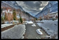
Delve into San Tomaso in Italy
San Tomaso in the region of Veneto with its 812 residents is located in Italy - some 311 mi or ( 500 km ) North of Rome , the country's capital .
Local time in San Tomaso is now 04:12 PM (Monday) . The local timezone is named " Europe/Rome " with a UTC offset of 1 hours. Depending on your mobility, these larger destinations might be interesting for you: Innsbruck, Munich, Prague, Zoldo Alto, and Vicenza. While being here, you might want to check out Innsbruck . We discovered some clip posted online . Scroll down to see the most favourite one or select the video collection in the navigation. Are you curious about the possible sightseeing spots and facts in San Tomaso ? We have collected some references on our attractions page.
Videos
ZIPLINE SanTomaso
The new Zipline San Tomaso by Adrenaline X-Treme Adventures La nuova Zipline San Tomaso ..
I serrai di Sottoguda
La Famiglia Dell'Antone ha il piacere di presentarvi i Serrai di Sottoguda ..
Ferro Battuto in Marmolada-Val Pettorina | La Fosina
..
wycieczka Cencenighe
wycieczka Cencenighe ..
Videos provided by Youtube are under the copyright of their owners.
Interesting facts about this location
Giardino Alpino "Antonio Segni"
The Giardino Alpino "Antonio Segni" (5,000 m²) is an alpine botanical garden located at 1,714 meters altitude in Refugio Vazzoler, Gruppo del Civetta, Col Negro di Pelsa, Taibon Agordino, Province of Belluno, Veneto, Italy. It is privately owned with a municipal affiliation, and open daily when Refugio Vazzoler is open. The garden was established in 1968 in the Dolomites, and named after Italian President Antonio Segni (1891-1972).
Located at 46.38 12.05 (Lat./Long.); Less than 6 km away
Lago Fedaia
Lago Fedaia is a lake in Trentino and the Province of Belluno, Italy.
Located at 46.46 11.88 (Lat./Long.); Less than 11 km away
Pala group
The Pala group (Italian: Pale di San Martino, Dolomiti delle Pale or Gruppo delle Pale) is a mountain range in the Dolomites, in the eastern Trentino and part of the province of Belluno, northern Italy. They cover an area of c. 240 km² between the Primiero, Valle del Biois and Agordino. They include a large plateau (altopiano delle Pale), spanning for some 50 km² between 2,500 and 2,800 m, an empty rocky extent. Geologically, they are composed of dolostone.
Located at 46.27 11.87 (Lat./Long.); Less than 15 km away
Vezzana
The Vezzana (also Cima di Vezzana) is the highest peak in the Pale di San Martino, a mountain group in the Dolomites, northern Italy. It is located in the northern part of the Dolomites, between the Agordino and Primiero. It has an altitude of 3,192 metres. The peak is flanked by that of the Cimon della Pala. It was first ascended in 1872 by Douglas William Freshfield and Charles Comyns Tucker, who reached it from the Travignolo glacier and the Passo di Travignolo.
Located at 46.25 11.87 (Lat./Long.); Less than 17 km away
Sella group
The Sella is a plateau shaped massif in the Dolomites mountains of northern Italy. The Sella lies north of the Marmolada and to the east of the Langkofel. The highest peak is Piz Boè at 3,151 m above sea level. The Sella lies between the four Ladin valleys of Badia, Gherdëina, Fascia, and Fodom and is divided between the provinces of South Tyrol, Trentino and Belluno. It can be driven around by car crossing the Campolongo Pass, Pordoi Pass, Sella Pass, and Gardena Pass.
Located at 46.50 11.83 (Lat./Long.); Less than 17 km away
Pictures
Historical Weather
Related Locations
Information of geographic nature is based on public data provided by geonames.org, CIA world facts book, Unesco, DBpedia and wikipedia. Weather is based on NOAA GFS.


