-
You are here:
- Homepage » Kiribati
Kiribati Country Guide
Explore Kiribati in Oceania
Kiribati with the capital city South Tarawa is located in Oceania (Oceania, group of 33 coral atolls in the Pacific Ocean). It covers some 811 square kilometres (four times the size of Washington, DC) with 110,000 citizens.
The landscape offers mostly low-lying coral atolls surrounded by extensive reefs. The average density of population is approximately 136 per km². The notable climate conditions in Kiribati can be described as tropical with marine, hot and humid, moderated by trade winds. Potential threats by nature are typhoons can occur any time, but usually November to March or occasional tornadoes or low level of some of the islands make them sensitive to changes in sea level.
To reach someone in Kiribati dial +686 prior to a number. There are 4,000 installed telephones. And there are 1,000 registered mobile phones. The cellular networks commonly support frequencies of 900 MHz. Websites registered in this country end with the top level domain ".ki". If you want to bring electric equipment on your trip (e.g. laptop power supply), note the local power outlet of 240V - 50Hz.
About the flag and history of Kiribati
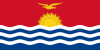
The upper half is red with a yellow frigatebird flying over a yellow rising sun, and the lower half is blue with three horizontal wavy white stripes to represent the Pacific ocean; the white stripes represent the three island groups - the Gilbert, Line, and Phoenix Islands; the 17 rays of the sun represent the 16 Gilbert Islands and Banaba (formerly Ocean Island); the frigatebird symbolizes authority and freedom.
The Gilbert Islands became a British protectorate in 1892 and a colony in 1915; they were captured by the Japanese in the Pacific War in 1941. The islands of Makin and Tarawa were the sites of major US amphibious victories over entrenched Japanese garrisons in 1943. The Gilbert Islands were granted self-rule by the UK in 1971 and complete independence in 1979 under the new name of Kiribati. The US relinquished all claims to the sparsely inhabited Phoenix and Line Island groups in a 1979 treaty of friendship with Kiribati.
Geography Quick-Facts
| Summary | Continent: Oceania Neighbours: Capital: South Tarawa |
| Size | 811 square kilometers (km² or sqkm) or 313 square miles (mi² or sqmi) four times the size of Washington, DC |
| Population | 110,000 |
| Currency | Name Dollar, Currency Code:AUD |
| Country Top Level Domain (cTLD) | .ki |
| Telephone Country Prefix | +686 |
| Mobile Phone Connections | 1,000 |
| Landline Phone Connections | 4,000 |
Country Position in World Rankings
Information about single country attributes and how these compare against the rest of the world. The information below is compiled with data from 2013. As such, it may differ a bit to the Information above in the text (which is from 2010).
Geography
| Value name | Value | World Rank |
|---|---|---|
| Area | 811 (sq km) | 187 |
People and Society
| Value name | Value | World Rank |
|---|---|---|
| Population | 103,248 | 194 |
| Population growth rate | 1.21 (%) | 96 |
| Birth rate | 22.18 (births/1,000 population) | 74 |
| Death rate | 7.24 (deaths/1,000 population) | 122 |
| Net migration rate | -2.86 (migrant(s)/1,000 population) | 174 |
| Maternal mortality rate | 9.00 (deaths/100,000 live births) | 155 |
| Infant mortality rate | 36.50 (deaths/1,000 live births) | 63 |
| Life expectancy at birth | 65.11 (years) | 173 |
| Total fertility rate | 2.63 (children born/woman) | 77 |
| Health expenditures | 11.30 (% of GDP) | 16 |
| Obesity - adult prevalence rate | 46.00 (%) | 8 |
| Education expenditures | 11.60 (% of GDP) | 4 |
Economy
| Value name | Value | World Rank |
|---|---|---|
| GDP (purchasing power parity) | 636,300,000 | 212 |
| GDP - real growth rate | 2.50 (%) | 124 |
| GDP - per capita (PPP) | 6,100 | 148 |
| Labor force | 7,870 | 218 |
| Unemployment rate | 2.00 (%) | 15 |
| Taxes and other revenues | 32.10 (% of GDP) | 81 |
| Budget surplus (+) or deficit (-) | -29.80 (% of GDP) | 216 |
| Inflation rate (consumer prices) | 0.20 (%) | 5 |
| Current account balance | -35,010,000 | 62 |
| Exports | 7,066,000 | 215 |
| Imports | 80,090,000 | 216 |
| Debt - external | 10,000,000 | 196 |
Energy
| Value name | Value | World Rank |
|---|---|---|
| Electricity - production | 21,000,000 (kWh) | 213 |
| Electricity - consumption | 19,530,000 (kWh) | 213 |
| Electricity - installed generating capacity | 6,000 (kW) | 207 |
| Electricity - from fossil fuels | 100.00 (% of total installed capacity) | 19 |
| Refined petroleum products - consumption | 300 (bbl/day) | 210 |
| Refined petroleum products - imports | 261 (bbl/day) | 205 |
| Carbon dioxide emissions from consumption of energy | 43,690 (Mt) | 207 |
Communications
| Value name | Value | World Rank |
|---|---|---|
| Telephones - main lines in use | 8,500 | 201 |
| Telephones - mobile cellular | 13,800 | 210 |
| Internet hosts | 327 | 190 |
| Internet users | 7,800 | 204 |
Transportation
| Value name | Value | World Rank |
|---|---|---|
| Airports | 19 | 137 |
| Roadways | 670 (km) | 190 |
| Waterways | 5 (km) | 108 |
| Merchant marine | 77 | 58 |
Data based on CIA facts book 2010 & 2013, wikipedia, national statistical offices and their census releases
List of current world heritage sites
| Name | Since |
|---|---|
| Phoenix Islands Protected Area The Phoenix Island Protected Area (PIPA) is a 408,250 sq.km expanse of marine and terrestrial habitats in the Southern Pacific Ocean. The property encompasses the Phoenix Island Group, one of three island groups in Kiribati, and is the largest design ... | 2010 |