-
You are here:
- Homepage »
- Mexico »
- Guanajuato » Celaya

Celaya Destination Guide
Explore Celaya in Mexico
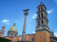
Celaya in the region of Guanajuato with its 305,901 inhabitants is a town in Mexico - some 133 mi or ( 214 km ) North-West of Mexico City , the country's capital city .
Current time in Celaya is now 01:29 PM (Wednesday) . The local timezone is named " America/Mexico City " with a UTC offset of -6 hours. Depending on the availability of means of transportation, these more prominent locations might be interesting for you: Toluca, Puebla, Mexico City, San Miguel Octopan, and San Juan de la Vega. Since you are here already, make sure to check out Toluca . We encountered some video on the web . Scroll down to see the most favourite one or select the video collection in the navigation. Where to go and what to see in Celaya ? We have collected some references on our attractions page.
Videos
Plastic Surgery in Mexico
CNN Clip about Plastic Surgery in Mexico.Interview with Dr. Carlos Barrera director of CIRUPLAS Facelift Surgery Specialist Center in Guanajuato Mexico. www.faceliftmexico.com.mx ..
Scramcnc cnc dual foam cutter and router series
ScramCNC dual series Cnc cuting conical foam shapes, and carving in MDF with dual function router and foam poliestirene 3D www.scramcnc.com ..
Mexican Culture 101: Cena
www.twitter.com Every week I plan to go over one aspect of Mexican culture that is different than the United States and Canada. Today the lesson is on cena, a late night meal that is eaten at home or ..
RI D4160 MEXICO YEP - Ruta Maya 2009
Rotary International District 4160 MEXICO Youth Exchange Program - Ruta Maya 2009 Road trip thru south of Mexico, organized by Rotary International District 4160 to inbound students. They visited 8 st ..
Videos provided by Youtube are under the copyright of their owners.
Interesting facts about this location
Celaya
Celaya is a city and its surrounding municipality in the state of Guanajuato, Mexico, located in the southeast quadrant of the state. It is the third most populous city in the state, with a 2005 census population of 310,413. The municipality for which the city serves as municipal seat, had a population of 415,869.
Located at 20.52 -100.81 (Lat./Long.); Less than 1 km away
Estadio Miguel Alemán
The Estadio Miguel Alemán is a multi-use stadium in Celaya, Guanajuato. Mexico. It is currently used mostly for football matches and is the home stadium of FC Celaya. The stadium holds 25,500 people and opened in 1954. It was named for Miguel Alemán Valdés, President of the Republic from 1946 to 1952.
Located at 20.53 -100.82 (Lat./Long.); Less than 2 km away
Captain Rogelio Castillo National Airport
Captain Rogelio Castillo National Airport (Spanish: Aeropuerto Nacional Capitán Rogelio Castillo) is an airport serving Celaya, a city in the state of Guanajuato in Mexico. It is located 15 minutes away from downtown, and is mainly used for general aviation purposes. It is operated by "Patronato del Aeropuerto de Celaya", a government-owned corporation. The airport had a few flights to Ixtapa in November 2004 but the service was cancelled due to the very few people that bought tickets.
Located at 20.55 -100.89 (Lat./Long.); Less than 8 km away
Cortazar, Guanajuato
Cortazar is a city and its surrounding municipality located in the southeastern quadrant of the state of Guanajuato in Mexico. It is bordered to the north by Villagrán, to the north and east by Celaya, to the southeast by Tarimoro, to the south by Salvatierra, and to the west by Jaral del Progreso and Salamanca. The city had a 2005 census population of 57,748 inhabitants, while the municipality had a population of 83,175.
Located at 20.48 -100.93 (Lat./Long.); Less than 13 km away
Apaseo el Grande
Apaseo el Grande is a Mexican city located in the state of Guanajuato. The municipality has an area of 415.26 square kilometres (1.37% of the surface of the state) and is bordered to the north by Comonfort and San Miguel de Allende, to the east by the state of Querétaro, to the south by Apaseo el Alto, and to the west by Celaya. The municipality had a population of 68,738 inhabitants according to the 2005 census.
Located at 20.57 -100.70 (Lat./Long.); Less than 13 km away
Pictures
Related Locations
Information of geographic nature is based on public data provided by geonames.org, CIA world facts book, Unesco, DBpedia and wikipedia. Weather is based on NOAA GFS.

