
Explore Santa Cruz Xoxocotlan in Mexico
Santa Cruz Xoxocotlan in the region of Oaxaca with its 61,846 inhabitants is a place in Mexico - some 229 mi or ( 369 km ) South-East of Mexico City , the country's capital city .
Time in Santa Cruz Xoxocotlan is now 03:40 PM (Tuesday) . The local timezone is named " America/Mexico City " with a UTC offset of -6 hours. Depending on your budget, these more prominent locations might be interesting for you: Zimatlan de Alvarez, Trinidad de Zaachila, Tlalixtac de Cabrera, Santa Maria del Tule, and Teitipac. Since you are here already, consider visiting Zimatlan de Alvarez . We saw some hobby film on the internet . Scroll down to see the most favourite one or select the video collection in the navigation. Where to go and what to see in Santa Cruz Xoxocotlan ? We have collected some references on our attractions page.
Videos
OAX Oaxaca Mexico Landing Embraer
Landing Embraer at OAX ..
Mezcal production in Oaxaca
Eva, Matej and myself visited a town in Oaxaca that produces Mezcal, similar to the Tequila, made out of Agave, here we found out what is needed in order to produce this "happy water". Cheers! Isra ..
misled children and odean pope - bananas foster
misled children and odean pope - bananas foster playlist : www.youtube.com Time Lapse Vid : sunset 21.2.2010 / Oaxaca (City) , Oaxaca , Mexico ..
Chocosol Chocolate: From Beans to Bar
I followed Micheal Sacco, a chocolatier, through the remote jungles in Oaxaca Mexico to find out the true story of chocolate. It was an amazing trip, where I learned not only the story of Micheal's am ..
Videos provided by Youtube are under the copyright of their owners.
Interesting facts about this location
Santa Cruz Xoxocotlán
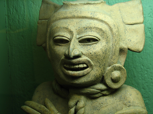
Santa Cruz Xoxocotlán is a small city and municipality located 5 km from the state capital of Oaxaca in the south of Mexico. It is part of the Centro District in the Valles Centrales region. The name comes from the Nahuatl word “xocotl” which means “sour or sweet and sour fruit” with the duplicative “xo” to indicate “very. ” The meaning of the entire phrase means “among the very sour fruits. ” The Mixtec name for the area was Nuunitatnohoyoo which mean “land of the moon-faced flowers.
Located at 17.02 -96.73 (Lat./Long.); Less than 0 km away
Xoxocotlán International Airport
Xoxocotlán International Airport Is an international airport located at Oaxaca, Oaxaca, Mexico. The airport has only one terminal that handles domestic and international air traffic.
Located at 17.00 -96.73 (Lat./Long.); Less than 2 km away
Benito Juárez Autonomous University of Oaxaca
The Benito Juárez Autonomous University of Oaxaca (Spanish: Universidad Autónoma Benito Juárez de Oaxaca, UABJO) is a public university located in the city of Oaxaca de Juárez in state of Oaxaca, Mexico. The University was founded on January 8, 1827 as the Oaxacan Institute for Arts and Sciences.
Located at 17.05 -96.71 (Lat./Long.); Less than 4 km away
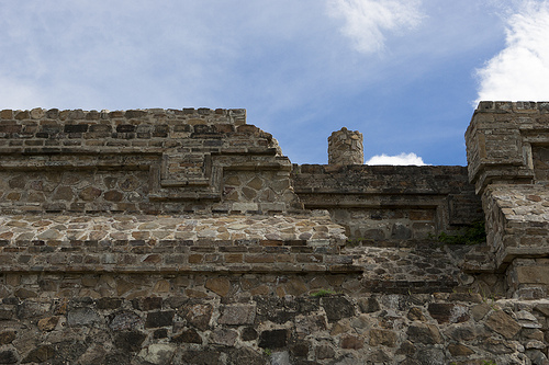
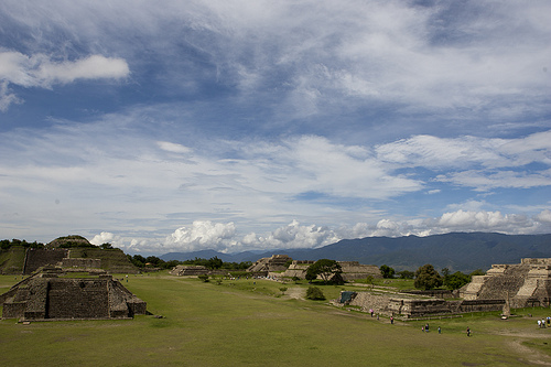
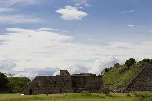
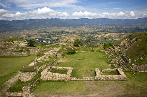
Monte Albán
Monte Albán is a large pre-Columbian archaeological site in the Santa Cruz Xoxocotlán Municipality in the southern Mexican state of Oaxaca (17.043° N, 96.767°W). The site is located on a low mountainous range rising above the plain in the central section of the Valley of Oaxaca where the latter's northern Etla, eastern Tlacolula, and southern Zimatlán & Ocotlán branches meet. The present-day state capital Oaxaca City is located approximately 9 km east of Monte Albán.
Located at 17.04 -96.77 (Lat./Long.); Less than 5 km away
Valley of Oaxaca
The Valley of Oaxaca is a geographic region located within the modern day State of Oaxaca in southern Mexico. The valley, which is located within the Sierra Madre Mountains, is shaped like a distorted and almost upside-down “Y,” with each of its arms bearing specific names: the northwestern Etla arm, the central southern Valle Grande, and the Tlacolula arm to the east.
Located at 17.05 -96.77 (Lat./Long.); Less than 5 km away
Pictures
Related Locations
Information of geographic nature is based on public data provided by geonames.org, CIA world facts book, Unesco, DBpedia and wikipedia. Weather is based on NOAA GFS.