-
You are here:
- Homepage »
- Spain »
- Canary Islands » Icod de los Vinos

Icod de los Vinos Destination Guide
Delve into Icod de los Vinos in Spain
Icod de los Vinos in the region of Canary Islands with its 24,024 residents is a city in Spain - some 1,112 mi or ( 1790 km ) South-West of Madrid , the country's capital .
Current time in Icod de los Vinos is now 05:31 AM (Tuesday) . The local timezone is named " Atlantic/Canary " with a UTC offset of 0 hours. Depending on your travel modalities, these larger destinations might be interesting for you: El Aaiún, Teror, Telde, Tegueste, and Tacoronte. While being here, make sure to check out El Aaiún . We encountered some video on the web . Scroll down to see the most favourite one or select the video collection in the navigation. Are you curious about the possible sightseeing spots and facts in Icod de los Vinos ? We have collected some references on our attractions page.
Videos
Was ist das? Lebendes Fleisch? (April 2012)
Beim Strandspaziergang fanden wir dies? Was ist es? Lebendes Fleisch? Einfach nur gruselig? Nicht von dieser Welt! ..
Loro Park Teneriffa - Pinguinarium
So schön kann der Winter auch sein. Teneriffa + 24 o und dann in die Arktislandschaft. Wir wünschen allen ein Frohes Weihnachtsfest und ein Glückliches Neues Jahr. euer VideoDu Team. ..
ICOD-PLAYA DE SAN MARCOS
Icod de los Vinos Localidad situada al norte de la isla de Tenerife. Playa de San Marcos. ..
CASA IDA Rural Tourism in Garachico Tenerife
Casa Ida is the perfect choice to enjoy some relaxing vacations in Garachico and disconnect from the daily routine. 5 independent little houses, tastefully furnished , each one with lounge and complet ..
Videos provided by Youtube are under the copyright of their owners.
Interesting facts about this location
Icod de los Vinos
Icod de los Vinos is a municipality in the province of Santa Cruz de Tenerife on the island of Tenerife, in the Canary Islands, located in the northwest part of the island. Inhabitants of Icod are known in Spanish as "icodenses". Icod has an area of 95.90 km², is situated at an altitude of 235 metres above sea level, and has a population of 24,179 as of 2006. http://www. gobiernodecanarias. org/istac/
Located at 28.35 -16.70 (Lat./Long.); Less than 3 km away
Cueva del Viento
Cueva del Viento-Sobrado (Wind Cave) underground complex is the largest lava tube in the European Union and one of the largest in the world. It is the fifth largest in the world behind a series of caves in Hawaii. It was created by lava flows from Pico Viejo, next to Mt. Teide. The cave is located in the town of Icod de los Vinos in the north of the island of Tenerife.
Located at 28.35 -16.72 (Lat./Long.); Less than 3 km away
El Tanque, Santa Cruz de Tenerife
El Tanque is a municipality in the northwestern part of the island of Tenerife, one of the Canary Islands, and part of the province of Santa Cruz de Tenerife. It is located about 90 km SSW of the island's capital, NW of Los Cristianos and Playa de las Américas of Arona and about 60 km NW of Reina Sofia Airport. The population is 3,198, its density is 135.28/km² and the area is 23.64 km². The elevation is 480 m.
Located at 28.35 -16.75 (Lat./Long.); Less than 4 km away
Roque de Garachico
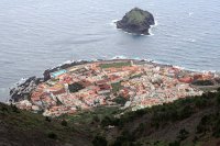
Roque de Garachico is a small island or roque located on the north coast of the island of Tenerife belonging to the municipality of Garachico. With approximately 5 hectares, this area was protected in 1987.
Located at 28.38 -16.76 (Lat./Long.); Less than 5 km away
San Juan de la Rambla, Santa Cruz de Tenerife
San Juan de la Rambla is a municipality in the northern part of the island of Tenerife, one of the Canary Islands, and part of the province of Santa Cruz de Tenerife. It is located about 50 km SSW of the island's capital, N of Los Cristianos and Las Américas of Arona and about 75 km north of Tenerife South Airport. The population is 5,027, its density is 243.32/km² and the area is 20.66 km². The elevation is 501 m.
Located at 28.37 -16.62 (Lat./Long.); Less than 9 km away
Pictures
Related Locations
Information of geographic nature is based on public data provided by geonames.org, CIA world facts book, Unesco, DBpedia and wikipedia. Weather is based on NOAA GFS.


