-
You are here:
- Homepage »
- Spain »
- Canary Islands » Tejeda

Tejeda Destination Guide
Touring Tejeda in Spain
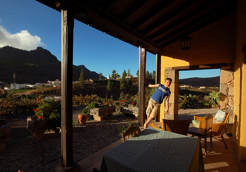
Tejeda in the region of Canary Islands with its 2,338 citizens is located in Spain - some 1,093 mi or ( 1759 km ) South-West of Madrid , the country's capital city .
Time in Tejeda is now 06:46 PM (Monday) . The local timezone is named " Atlantic/Canary " with a UTC offset of 0 hours. Depending on your budget, these more prominent places might be interesting for you: El Aaiún, Vega de San Mateo, Telde, Tegueste, and Tacoronte. Being here already, consider visiting El Aaiún . We collected some hobby film on the internet . Scroll down to see the most favourite one or select the video collection in the navigation. Check out our recommendations for Tejeda ? We have collected some references on our attractions page.
Videos
Mountainbike Gran Canaria - Bullet HD
Mountainbike Urlaub auf Gran Canaria Videomaterial von verschiedenen Mountainbike-Touren im Süden Gran Canarias und einer Rennrad- Ausfahrt auf den Gipfel der Insel, den Pico De Las Nieves. Gefilmt mi ..
Gran Canaria - San Agustin
PMMedia1: San Agustin gehört neben Maspalomas und Playa del Ingles zu den großen Ferienorten der Costa Canaria. Die Hotels, Bungalows und Apartmenthäuser reichen in mehreren Stufen fast bis zum Atlant ..
Gran Canaria - Ausflug in die Bergwelt
PMMedia1: Die ohne Frage schönste Autotour auf Gran Canaria führt in das zentrale Bergland der Insel. Um die landschaftlichen Eindrücke voll aufnehmen zu können und der mittäglichen Passat-Wolkenbildu ..
Video Gran Canaria - Choose a grand destination
www.vuango.com - Video Gran Canaria is the first place to go if you need to find somewhere to chill out or to find luxury accommodation or holidays where the sun almost always shines. Visit Vuango to ..
Videos provided by Youtube are under the copyright of their owners.
Interesting facts about this location
Tejeda
Tejeda is a Canarian municipality in the westcentral and the central portion of the island of Gran Canaria in the Las Palmas province in the Canary Islands. Tejeda is the main city of Cumbre and is the second smallest village on the island as well as the highest municipal seat on the island. The population is 2,347, its density is 22.73/km² and the area is 103.29 km². Tejeda is situated in the mountains and the valley area that are mainly covered with greenspaces and forests.
Located at 28.00 -15.62 (Lat./Long.); Less than 0 km away
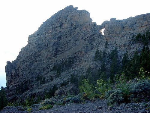
Roque Nublo
Roque Nublo (Spanish meaning the "Rock Clouded") is a monolith feature that is 80 m tall. It is one of the most famous landmarks on the island of Gran Canaria. The elevation is 1,813 m, ranking it second on the island and one of the tallest in the archipelago. It is municipally located in Tejeda, a few kilometres from the town centre. It was formed by a volcanic eruption around 4.5 million years ago. It can be reached very easily by hiking some 30 minutes from a nearby parking lot.
Located at 27.97 -15.61 (Lat./Long.); Less than 3 km away
Gran Canaria
Gran Canaria (originally meaning 'Great of Dogs') is the second most populous island of the Canary Islands, a Spanish archipelago, with a population of 838,397 which constitutes approximately 40% of the population of the archipelago. Located in the Atlantic Ocean about 150 kilometers (~93 miles) off the northwestern coast of Africa and about 1350 km (~838 miles) from Europe. Gran Canaria was populated by the Canarii (Guanches), who may have arrived as early as 500 BC.
Located at 27.97 -15.60 (Lat./Long.); Less than 4 km away
San Bartolomé de Tirajana
San Bartolomé de Tirajana is a Canarian municipality in the southeastern portion of the island of Gran Canaria in the Las Palmas province in the Canary Islands. San Bartolomé de Tirajana is the largest municipality in area on the island as well as the Canary Islands almost covering between a quarter and one-third of the whole island of Gran Canaria and more than 5 to 6% of the archipelago. The capital is situated in "La Caldera de Las Tirajanas".
Located at 27.93 -15.55 (Lat./Long.); Less than 9 km away
Valleseco, Las Palmas
Valleseco is a municipality of Las Palmas province, on the Canary Islands. It is in the northcentral part of Gran Canaria. Valleseco means "dry valley" in Spanish, but its name is misleading, since it is actually one of the wettest municipalities of the island. Valleseco's area is 22.11 km² with a population of about 4,045 and its density is 182.95/km². The elevation is 1,000 m. Valleseco is a municipality situated at 7 km. from Teror and 28 from the city of Las Palmas.
Located at 28.07 -15.55 (Lat./Long.); Less than 10 km away
Pictures


Related Locations
Information of geographic nature is based on public data provided by geonames.org, CIA world facts book, Unesco, DBpedia and wikipedia. Weather is based on NOAA GFS.