-
You are here:
- Homepage »
- Switzerland »
- Valais » Saint-Martin

Saint-Martin Destination Guide
Explore Saint-Martin in Switzerland
Saint-Martin in the region of Valais with its 751 inhabitants is a town in Switzerland - some 54 mi or ( 86 km ) South of Berne , the country's capital city .
Current time in Saint-Martin is now 11:20 AM (Monday) . The local timezone is named " Europe/Zurich " with a UTC offset of 1 hours. Depending on the availability of means of transportation, these more prominent locations might be interesting for you: Zurich, Vissoie, Sion, Saint-Martin, and Saint-Luc. Since you are here already, make sure to check out Zurich . We encountered some video on the web . Scroll down to see the most favourite one or select the video collection in the navigation. Where to go and what to see in Saint-Martin ? We have collected some references on our attractions page.
Videos
Coeur du Valais, le Val d'Hérens et le Parc Naturel vu du ciel.
Coeur du Valais, le Val d'Hérens et le Parc Naturel vu du ciel. Dans la région de Sion, découvrez le Parc Naturel Hérens, de la Vallée du Rhône aux fameux sommets des Alpes (Cervin, Dt-Blanche,...). L ..
How Many Are In Yours?
It's Wednesday somewhere. I love you. I mean it. -Mary B. xoxxx Mary B. is a traveling word nerd who blogs about life and love and why reading is sexy. She started in 2007 playing with her little mons ..
Les reines de Bouzerou
elles sont les reines du Valais, les vaches les plus sympa du monde, les belles noires de la race d'Hérens, enfin sur Internet ..
Les 4 Vallées 2008
winter hollidays, january 2008 download in better quality mrdx.eu (100MB) ... ..
Videos provided by Youtube are under the copyright of their owners.
Interesting facts about this location
Euseigne
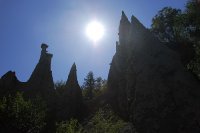
Euseigne is a village in the Swiss Alps, located in the canton of Valais. The village is situated in the central part of the canton, in the Val d'Hérens, south of Sion. It belongs to the municipality of Hérémence Euseigne lies at a height of 975 metres above sea level, on the main road connecting Evolène from Sion. The village is well known for the fairy chimney rock formations named Pyramides d'Euseigne.
Located at 46.17 7.42 (Lat./Long.); Less than 2 km away
Hérens (district)
The district of Hérens is a district in the canton of Valais in Switzerland. It has a population of 10,542 (as of 31 December 2011).
Located at 46.19 7.42 (Lat./Long.); Less than 3 km away
Les Masses
Les Masses is a small ski resort town in Val d'Herens. Les Masses is part of the municipality of Hérémence, Valais, Switzerland. It is in the Four Valleys ski area, in the easternmost part, at 1500 metres altitude. Les Masses was formerly an area with a few barns and shooting sheds. It is still a very quiet place. The houses are nearly all wooden chalets, with only a few apartment buildings no higher than three or four floors.
Located at 46.18 7.40 (Lat./Long.); Less than 4 km away
Val d'Hérens
Val d'Hérens is an alpine valley in the Valais canton of Switzerland. It was formed by the Hérens glacier, which retreated at the end of the last ice age. It extends from the Rhône valley to a number of high mountains - Dent Blanche, Dent d'Hérens, Mont Collon, Mont Blanc de Cheilon. It is a popular start point for mountain expeditions. The area has two mountain peaks over 4,000 metres in altitude: la Dent Blanche ("white tooth") at 4,357 m, and la Dent d'Hérens ("Hérens tooth") at 4,171m.
Located at 46.13 7.47 (Lat./Long.); Less than 5 km away
Val d'Anniviers
The val d'Anniviers is a Swiss alpine valley, situated in the district of Sierre in Valais, which extends south of the Rhône Valley, on the northern slopes of the Pennine Alps. The valley was home to six municipalities: Ayer, Chandolin, Grimentz, Saint-Jean, Saint-Luc, Vissoie, Vercorin and Zinal. The citizens of those municipalities agreed on November 26, 2006, to merge into one, which was named Anniviers. The merger took place in January 2009.
Located at 46.20 7.50 (Lat./Long.); Less than 5 km away
Pictures
Historical Weather
Related Locations
Information of geographic nature is based on public data provided by geonames.org, CIA world facts book, Unesco, DBpedia and wikipedia. Weather is based on NOAA GFS.


