-
You are here:
- Homepage »
- United Kingdom »
- England » North Ferriby

North Ferriby Destination Guide
Explore North Ferriby in United Kingdom
North Ferriby in the region of England with its 7,416 inhabitants is a town in United Kingdom - some 154 mi or ( 247 km ) North of London , the country's capital city .
Current time in North Ferriby is now 09:26 PM (Thursday) . The local timezone is named " Europe/London " with a UTC offset of 0 hours. Depending on the availability of means of transportation, these more prominent locations might be interesting for you: York, Swanland, Skidby, Sheffield, and Scunthorpe. Since you are here already, make sure to check out York . We saw some video on the web . Scroll down to see the most favourite one or select the video collection in the navigation. Where to go and what to see in North Ferriby ? We have collected some references on our attractions page.
Videos
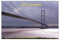
Truck ride, Humber Bridge To Hull
Reload this video and add .... &fmt=18 ...at the end of the addy to get better quality and STEREO! Short run over the Humber Bridge. ..
Humber Bridge part 1(Moving road deck in high winds)
This short clip & a couple of others to follow are from a visit to Hull & the Humber Bridge.I'd seen this done on BBC Look North so thought I'd try it out.This is on the north tower of the Humber brid ..
World record scooter Rally Humber bridge.Part one
Humber Bridge Scooter rally World record attempt August 14 TH 2010 Lead by Andrew White (Kaiser Chiefs) ..
YSA Humber Bridge World Record Scooter Crossing
On August 14th 2010 an attempt of the world record for the most scooters crossing a bridge in one continuous line was made. This is our video of the crossing. ..
Videos provided by Youtube are under the copyright of their owners.
Interesting facts about this location
The Wolds
The Wolds is a term used, in England, to describe a range of hills which consists of open country overlying a base of limestone or chalk. Wold, is derived from the Old English Wald meaning forest. Over the years the meaning has changed from forest to open high ground.
Located at 53.75 -0.50 (Lat./Long.); Less than 3 km away
Hessle High School
Hessle High School is an academy school in Hessle, East Riding of Yorkshire near Hull, England. The School's Heads Lane site is centred on Tranby House, originally built in 1807 by local merchant John Barkworth. The house is an almost exact duplicate of the now-demolished Tranby Lodge, and Hessle Mount, now a private junior school. This building was also the home of Algernon Barkworth, a descendant of John Barkworth.
Located at 53.73 -0.45 (Lat./Long.); Less than 3 km away
Robert Raikes (1765–1837)
Robert Raikes Esq. (1765 – 1837), was an English banker, originally from London, that later established a bank in Kingston upon Hull. After 1805 he lived at Welton House in Welton, East Riding of Yorkshire, where in 1818 he had built a family mausoleum in park land to the north. He was the son of William Raikes, who had built a mausoleum in the Churchyard of St Mary, Woodford, London.
Located at 53.75 -0.54 (Lat./Long.); Less than 4 km away
Tranby Croft
Tranby Croft is a large Grade II listed Victorian country house and estate at Anlaby, near Hull in the East Riding of Yorkshire, England. The house is now the co-educational, independent day school, Hull Collegiate School. The house is built in white brick with ashlar dressing in three storeys with a nine bay frontage.
Located at 53.74 -0.45 (Lat./Long.); Less than 4 km away
Yorkshire Wolds Way
The Yorkshire Wolds Way is a National Trail in Yorkshire, England. It runs 79 miles (127 km) from Hessle to Filey, around the Yorkshire Wolds. At Filey, it connects with the Cleveland Way, another National Trail. In 2007 the Yorkshire Wolds Way celebrated the 25th anniversary of its official opening which took place on 2 October 1982.
Located at 53.72 -0.44 (Lat./Long.); Less than 5 km away
Pictures
Related Locations
Information of geographic nature is based on public data provided by geonames.org, CIA world facts book, Unesco, DBpedia and wikipedia. Weather is based on NOAA GFS.


