-
You are here:
- Homepage »
- United Kingdom »
- England » Slingsby

Slingsby Destination Guide
Delve into Slingsby in United Kingdom
Slingsby in the region of England is located in United Kingdom - some 187 mi or ( 300 km ) North of London , the country's capital .
Local time in Slingsby is now 01:18 AM (Saturday) . The local timezone is named " Europe/London " with a UTC offset of 0 hours. Depending on your mobility, these larger destinations might be interesting for you: York, Wigginton, Welburn, Strensall, and Sheffield. While being here, you might want to check out York . We discovered some clip posted online . Scroll down to see the most favourite one or select the video collection in the navigation. Are you curious about the possible sightseeing spots and facts in Slingsby ? We have collected some references on our attractions page.
Videos
Unlucky People
I was on a trip with i2i and one of the challenges was to build a boat and 'paddle' to the end and back..... But the 'boateers' rather swam than paddle ..
Beamish Cog 2
Believed to be the Uk's only 7.25 inch gauge cog railway running up a 10% incline and over a custom built viaduct that must be around 20ft high. Here is a trip up the bank looking backwards at the loc ..
Corkscrew - Flamingo Land (Offride)
An offride video of Corkscrew at Flamingo Land, UK, compiled of various shots taken in 2010. Corkscrew opened in 1983 at Flamingo Land, after previously operating at Spanish City Amusement Park from 1 ..
Little Monsters Den of Mischief Ghost Train Flamingo Land July 2012 HD for Andrew Russell
Taken on our recent trip to Flamingo Land, July 2012. My five year old absolutely loves this ride and we had to do it daily. Taken with my P300 nikon @ 1.8/f. Best camera lighting I have seen on this ..
Videos provided by Youtube are under the copyright of their owners.
Interesting facts about this location
Hovingham Hall
Hovingham Hall is a grade I listed Palladian-style mansion in the village of Hovingham, North Yorkshire, England, the home of the Worsley family and the childhood home of the Duchess of Kent. It was built in the 18th century on a site the Worsleys have occupied since the 16th century. It is built of limestone ashlar with Westmorland slate roofs to an L-shaped floor plan. An attached stable wing forms the main entrance.
Located at 54.17 -0.98 (Lat./Long.); Less than 3 km away
East Ness
East Ness and West Ness together form the English village of Ness, which sits on the south bank of the River Rye. The name Ness is believed to mean nose or headland in Medieval Norse, and Ness is the start of the hill that ultimately rises up to become Sutton Bank. The village of Ness is believed to have been split into West & East, following the Norman Invasion as the ownership of the village was split between two landlords. This land ownership split still continues today.
Located at 54.20 -0.94 (Lat./Long.); Less than 4 km away
Nunnington
Nunnington is a small village and civil parish in the Ryedale district of North Yorkshire, England. The river Rye runs through the village. Nunnington Hall is a Grade I listed mansion owned by the National Trust and open to the public. The parish church, dedicated to All Saints and St James, is also a Grade I listed building. The nave and chancel date from the late 13th century and the tower from 1672, but the tower, porch and vestry were rebuilt in 1883-4. There is a fine 17th century pulpit.
Located at 54.20 -0.98 (Lat./Long.); Less than 5 km away
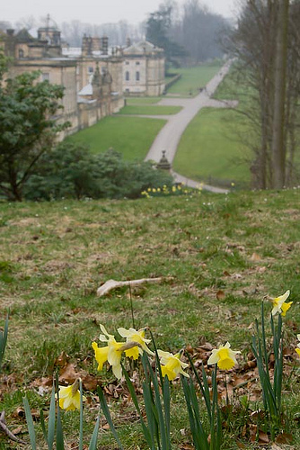
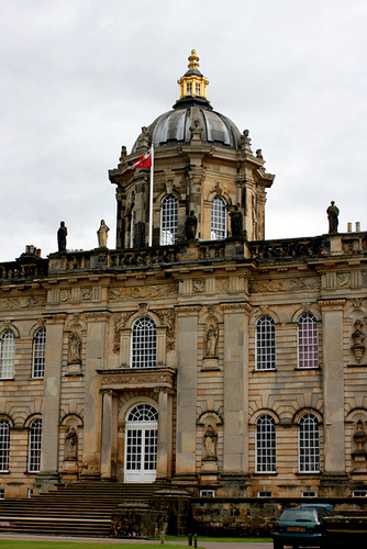
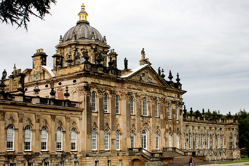
Castle Howard
Castle Howard is a stately home in North Yorkshire, England, 15 miles north of York. One of the grandest private residences in Britain, most of it was built between 1699 and 1712 for the 3rd Earl of Carlisle, to a design by Sir John Vanbrugh. Although Castle Howard was built near the site of the ruined Henderskelfe Castle, it is not a true castle, but this term is often used for English country houses constructed after the castle-building era (c.1500) and not intended for a military function.
Located at 54.12 -0.91 (Lat./Long.); Less than 5 km away
Nunnington Hall
Nunnington Hall is a country house situated in the English county of North Yorkshire. The river Rye, which gives its name to the local area, Ryedale, runs past the house, flowing away from the village of Nunnington. A stone bridge over the river separates the grounds of the house from the village. Above, a ridge known as Caulkley's Bank lies between Nunnington and the Vale of York to the south. The Vale of Pickering and the North York Moors lie to the north and east.
Located at 54.21 -0.97 (Lat./Long.); Less than 5 km away
Pictures
Related Locations
Information of geographic nature is based on public data provided by geonames.org, CIA world facts book, Unesco, DBpedia and wikipedia. Weather is based on NOAA GFS.