-
You are here:
- Homepage »
- United Kingdom »
- Scotland » Killin

Killin Destination Guide
Discover Killin in United Kingdom
Killin in the region of Scotland with its 666 habitants is a place located in United Kingdom - some 382 mi or ( 615 km ) North-West of London , the country's capital .
Local time in Killin is now 09:46 AM (Monday) . The local timezone is named " Europe/London " with a UTC offset of 0 hours. Depending on your mobility, these larger cities might be interesting for you: Strathyre, Stirling, Sheffield, Roromore, and Perth. When in this area, you might want to check out Strathyre . We discovered some clip posted online . Scroll down to see the most favourite one or select the video collection in the navigation. Are you looking for some initial hints on what might be interesting in Killin ? We have collected some references on our attractions page.
Videos
Scotland 2007 - Mountain Walks
Some of the Scottish hills and mountains we had walks on in 2007. In photo order, Luss Hills, Sow of Atholl/Meall na Leitreach, Meall Glas, An Socath, Meall na Fearna, Creag Meagaidh, An Caisteal/Bein ..
Entering Killin
Entering the town of Killin Scotland on the first day of our 4 day motorbike run ..
Triumph Bonneville Scotland Drift Innovation HD170 Stealth
Drift Innovation HD170 Stealth on a Triumph Bonneville touring Scotland. Tank mount captures the dials and allows a reverse view of the rider. ..
Schottland (11). Bahnhof Rannoch
Dieser Bahnhof liegt in den schottischen Highlands. Ab Rannoch gibt es keine Strasse mehr. Man kann von hier mit dem Zug über Oban bzw. über Fort William nach Mallaig (Mallaigh) ( (Endstation) fahren. ..
Videos provided by Youtube are under the copyright of their owners.
Interesting facts about this location
Inchbuie
Inchbuie is an island of the River Dochart, near Killin. A bridge links it with both riverbanks, just below the Falls of Dochart. The MacNab Clan were once dominant here, and have long been associated with Killin. Their ancient burial ground is visible from the bridge.
Located at 56.46 -4.32 (Lat./Long.); Less than 0 km away
Falls of Dochart
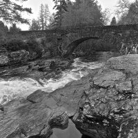
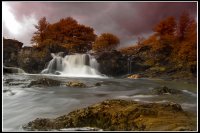
The Falls of Dochart are situated on the River Dochart at Killin in Stirling, Scotland at the western end of Loch Tay. A bridge crosses over the river just as you enter Killin giving a fabulous view of the falls as they cascade down over the rocks and around the island of Inchbuie, which is the traditional burial place of the MacNab clan.
Located at 56.46 -4.32 (Lat./Long.); Less than 0 km away
Finlarig Castle
Finlarig Castle is an early 17th century castle standing on a mound on a peninsula between the River Lochay and Loch Tay, roughly 1 kilometre north of Killin in highland Perthshire, Scotland. Built in 1629 by 'Black' Duncan Campbell (Donnchadh Dubh) of Glenorchy, the castle is an L-plan tower-house, formerly protected by an outer enclosure or barmekin, which is now in a dangerously ruinous condition. It was one of many strongholds built in Argyll and Perthshire by the Campbells of Breadalbane.
Located at 56.47 -4.31 (Lat./Long.); Less than 1 km away
Moirlanich Longhouse
Moirlanich Longhouse is a rare example of a cruck frame Scottish black house. It is located at grid reference NN562341 in Glen Lochay near Killin in the Stirling council area, Scotland. It is owned by the National Trust for Scotland and is open to visitors, from May to September, Sundays and Wednesdays, 2.00 - 5.00 p.m.
Located at 56.48 -4.34 (Lat./Long.); Less than 2 km away
River Dochart
The River Dochart is in Perthshire, Scotland. Coming from Ben Lui, it flows east out of Loch Dochart and through the glen of the same name. At Killin just before it enters Loch Tay are the Falls of Dochart. The river is sometimes also considered to be a part of the upper reaches of the River Tay.
Located at 56.48 -4.30 (Lat./Long.); Less than 2 km away
Pictures
Related Locations
Information of geographic nature is based on public data provided by geonames.org, CIA world facts book, Unesco, DBpedia and wikipedia. Weather is based on NOAA GFS.


