-
You are here:
- Homepage »
- United States »
- Massachusetts » Fiskdale

Fiskdale Destination Guide
Discover Fiskdale in United States
Fiskdale in the region of Massachusetts with its 2,583 habitants is a place located in United States - some 341 mi or ( 549 km ) North-East of Washington , the country's capital .
Local time in Fiskdale is now 08:51 AM (Thursday) . The local timezone is named " America/New York " with a UTC offset of -4 hours. Depending on your mobility, these larger cities might be interesting for you: Philadelphia, Hartford, Mashapaug, Boston, and Brimfield. When in this area, you might want to check out Philadelphia . We discovered some clip posted online . Scroll down to see the most favourite one or select the video collection in the navigation. Are you looking for some initial hints on what might be interesting in Fiskdale ? We have collected some references on our attractions page.
Videos
June 1 2011 Brimfield Sturbridge Tornado footage
Mixture of video footage and pictures of the wreckage in Brimfield Massachusetts around 1 stop towing with some pictures of what the places looked like before. I also have some footage from Sturbridge ..
GTA IV, parking like a boss.
no ..
Nipmuc Powwow 1
Chaubunagungamaug Band of Nipmuck Indians Powwow at Lake Siog, Holland, Massachusetts Sept. 6, 2008 ..
Thanksgiving Day at Old Sturbridge Village
Sights and sounds of the village from flintlock shooting to cooking to horse and coach rides on 11/26/09. ..
Videos provided by Youtube are under the copyright of their owners.
Interesting facts about this location
Fiskdale, Massachusetts
Fiskdale (or Fiskedale) is a census-designated place (CDP) in the town of Sturbridge in Worcester County, Massachusetts, United States. The population was 2,583 at the 2010 census.
Located at 42.12 -72.11 (Lat./Long.); Less than 0 km away
East Brimfield Dam
The East Brimfield Dam is located on the Quinebaug River in Sturbridge, Massachusetts, approximately 20 miles southwest of Worcester, Massachusetts. Designed and constructed by the United States Army Corps of Engineers, this dam substantially reduces flooding along the Quinebaug and Thames rivers. Construction of the project began in 1958 with completion in 1960 at a cost of US$7,020,000.
Located at 42.11 -72.13 (Lat./Long.); Less than 1 km away
Old Sturbridge Village
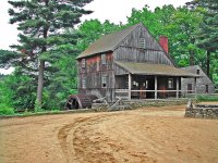
Old Sturbridge Village (OSV) is a living museum located in Sturbridge, Massachusetts, in the United States, which re-creates life in rural New England during the 1790s through 1830s. It is the largest living museum in New England, covering more than 200 acres (80 hectares). The Village includes 59 antique buildings, three water-powered mills, and a working farm. The museum is a popular tourist and educational field trip destination.
Located at 42.11 -72.10 (Lat./Long.); Less than 1 km away
Burgess Elementary School
Burgess Elementary School is a public school in Sturbridge, Massachusetts.
Located at 42.11 -72.10 (Lat./Long.); Less than 2 km away
Sturbridge (CDP), Massachusetts
Sturbridge is a census-designated place (CDP) in the town of Sturbridge in Worcester County, Massachusetts, United States. The population was 2,253 at the 2010 census.
Located at 42.10 -72.06 (Lat./Long.); Less than 5 km away
Pictures
Related Locations
Information of geographic nature is based on public data provided by geonames.org, CIA world facts book, Unesco, DBpedia and wikipedia. Weather is based on NOAA GFS.


