-
You are here:
- Homepage »
- United States »
- Utah » Fruit Heights

Fruit Heights Destination Guide
Explore Fruit Heights in United States
Fruit Heights in the region of Utah with its 4,987 inhabitants is a town in United States - some 1,840 mi or ( 2961 km ) West of Washington , the country's capital city .
Current time in Fruit Heights is now 11:12 PM (Thursday) . The local timezone is named " America/Denver " with a UTC offset of -6 hours. Depending on the availability of means of transportation, these more prominent locations might be interesting for you: Grand Junction, Idaho Falls, Pocatello, Bountiful, and Brigham City. Since you are here already, make sure to check out Grand Junction . We encountered some video on the web . Scroll down to see the most favourite one or select the video collection in the navigation. Where to go and what to see in Fruit Heights ? We have collected some references on our attractions page.
Videos
How to skitch in skate 2
Watch in high quality. This shows you how to skitch in skate 2. 1.Ride up to a car of your choice 2.Hold the RB as you approach the car 3.Use the Left Analog Stick to turn with the car 4.Get to the ed ..
Lagoon's OdySea
New For 2008! Climb aboard the OdySea, Lagoon's New Interactive Family Ride. Using The Joystick and Arrows in your Gondola, soar to Heights of 25ft to Avoid a Water Spraying Whale, Dolphin, and Shark. ..
Dustin Millen & Steve Pugh: Lagoon Catapult 2002
This is Steve and I at Lagoon in 2002 our senior year.. notice the young baby faces and the lovely Mexican mustache on my face :S .. anyway couple things to take note in this video.. one thing.. what ..
Air Race Opening Day Off-Ride at Lagoon Park
Off Ride Footage of Air Race, Lagoon's New For 2012 Ride. Air Race was Manufactured by Antonio Zamperla SpA of Italy for 2.5 Million Dollars and is Located at Lagoon Park in Farmington, Utah. ..
Videos provided by Youtube are under the copyright of their owners.
Interesting facts about this location
Davis High School (Kaysville, Utah)
Davis High School is a public school located in Kaysville, Utah, United States. It is operated by the Davis School District. The mascot of Davis High School is a Dart. The school was established in 1914 and underwent reconstruction during the 2003-2004 school year.
Located at 41.03 -111.93 (Lat./Long.); Less than 2 km away
Christopher Layton
Christopher Layton (March 8, 1821 – August 7, 1898) was a Mormon colonizer and Patriarch who founded the cities of Kaysville, Utah, Layton, Utah, and Thatcher, Arizona. Layton, Utah is named after him. Layton was born at Thorncote Green, Northill, Bedfordshire, England. He joined The Church of Jesus Christ of Latter-day Saints in 1842 and a year later emigrated to the United States. In 1846, Layton joined the Mormon Battalion. In 1852, he moved to Kaysville, Utah Territory.
Located at 41.04 -111.93 (Lat./Long.); Less than 2 km away
George D. Watt
George Darling Watt (May 12, 1812 – October 24, 1881) was the first convert to Mormonism baptized in the British Isles. As a member of The Church of Jesus Christ of Latter-day Saints (LDS Church), Watt was a secretary to Brigham Young, the primary editor of the Journal of Discourses and the primary inventor of the Deseret Alphabet. Watt was born in Manchester, England. While living in Preston as a young man, Watt was a member of the Reverend James Fielding's congregation.
Located at 41.05 -111.93 (Lat./Long.); Less than 3 km away
Utah Botanical Center
The Utah Botanical Center is a botanical garden located in Kaysville, Utah, and is a Utah State University (USU) distance education site. Originally located in Farmington, the garden moved to the current location in Kaysville in 1999. Through USU Extension, the center offers a Giving Garden, a 12,000 acre community farm. The farm is maintained by community members and all produce is donated to local food banks.
Located at 41.02 -111.94 (Lat./Long.); Less than 3 km away
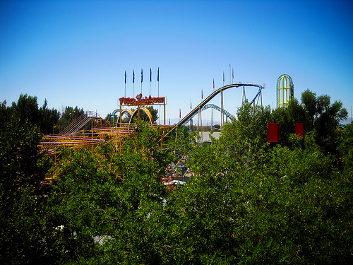
Bat (Lagoon)
The Bat is a Vekoma Suspended Family Coaster located at Lagoon Amusement Park in Farmington, Utah, United States.
Located at 40.99 -111.89 (Lat./Long.); Less than 5 km away
Pictures
Related Locations
Information of geographic nature is based on public data provided by geonames.org, CIA world facts book, Unesco, DBpedia and wikipedia. Weather is based on NOAA GFS.