-
You are here:
- Homepage »
- United States »
- Virginia » Triangle

Triangle Destination Guide
Explore Triangle in United States
Triangle in the region of Virginia with its 8,188 inhabitants is a town in United States - some 29 mi or ( 47 km ) South-West of Washington , the country's capital city .
Current time in Triangle is now 09:39 PM (Wednesday) . The local timezone is named " America/New York " with a UTC offset of -4 hours. Depending on the availability of means of transportation, these more prominent locations might be interesting for you: Washington, Baltimore, Raleigh, Philadelphia, and Alexandria. Since you are here already, make sure to check out Washington . We encountered some video on the web . Scroll down to see the most favourite one or select the video collection in the navigation. Where to go and what to see in Triangle ? We have collected some references on our attractions page.
Videos
JO Johnson High School Drill @ Nationals 2006
JO Johnson High School Drill @ Nationals 2006 ..
largest cities in the us
the 125 largest cities in the us by population when 2 or more cities have the same population, they're arranged alphabetically metropolitan areas aren't included ..
Not your Grandpa's '57 Chevy
This custom 57 Chevy is built for speed. Videotaped in Ocean City, Maryland by DougCameraMan. ..
New Jersey Reggae Fest 2011 Pt 1
10th Anniversary of the New Jersey International Reggae Fest in Newark, NJ THE NEW JERSEY REGGAE FEST: Launched in 2000 in Newark by G City Enterprise and Roadblockradio.com, the New Jersey Reggae Fes ..
Videos provided by Youtube are under the copyright of their owners.
Interesting facts about this location
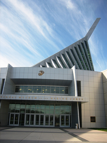
National Museum of the Marine Corps
The National Museum of the Marine Corps is the historical museum of the United States Marine Corps. Located in MCB Triangle, Virginia, the museum opened on November 10, 2006, and is now the top tourist attraction in the state, drawing over 500,000 people annually.
Located at 38.54 -77.34 (Lat./Long.); Less than 1 km away
Dumfries, Virginia
Dumfries is a town in Prince William County, Virginia, United States. The population was 4,961 at the 2010 census.
Located at 38.57 -77.32 (Lat./Long.); Less than 3 km away
Quantico Creek
Quantico Creek is a 13.7-mile-long tidal tributary of the Potomac River in eastern Prince William County, Virginia. Quantico Creek rises southeast of Independent Hill, flows through Prince William Forest Park and Dumfries and empties into the Potomac at Possum Point.
Located at 38.54 -77.29 (Lat./Long.); Less than 4 km away
Batestown, Virginia
Batestown is an extinct unincorporated town in Prince William County, Virginia. The town was located along the farthest terminus of Mine Road in what is now a western neighborhood of Dumfries along the banks of Quantico Creek. It was an enclave for freed slaves named for Mary Bates, the matriarch of the community. Batestown and Hickory Ridge both suffered the same fate.
Located at 38.58 -77.31 (Lat./Long.); Less than 4 km away
Chopawamsic Creek
Chopawamsic Creek is a 6.8-mile-long tributary of the Potomac River in Prince William and Stafford counties, Virginia. Chopawamsic Creek is formed by the confluence of the North and South Branches of Chopawamsic Creek and empties into the Potomac River south of Quantico at the Marine Corps Base Quantico's Air Station. Breckenridge Reservoir lies at the stream's confluence with the North and South Branches.
Located at 38.51 -77.32 (Lat./Long.); Less than 5 km away
Pictures


Related Locations
Information of geographic nature is based on public data provided by geonames.org, CIA world facts book, Unesco, DBpedia and wikipedia. Weather is based on NOAA GFS.