-
You are here:
- Homepage »
- Armenia »
- Syunik'i Marz » Shaghat

Shaghat Destination Guide
Discover Shaghat in Armenia
Shaghat in the region of Syunikʼ with its 1,011 habitants is a place located in Armenia - some 86 mi or ( 138 km ) South-East of Yerevan , the country's capital .
Local time in Shaghat is now 07:32 PM (Thursday) . The local timezone is named " Asia/Yerevan " with a UTC offset of 4 hours. Depending on your mobility, these larger cities might be interesting for you: Tabriz, Culfa, Agdam, T'asik, and Shak'i. When in this area, you might want to check out Tabriz . We discovered some clip posted online . Scroll down to see the most favourite one or select the video collection in the navigation. Are you looking for some initial hints on what might be interesting in Shaghat ? We have collected some references on our attractions page.
Videos
Armenia Noah's Route Your Route (CNN Europe)
Armenia Noah's Route Your Route (CNN Europe) ..
Carahunge Voice of America.mp4
armenian stonehenge , Qarahung , Qarahunj , Carahunge , Carahunj , Karahunge ,Karahunj armenian stonehenge , Քարահունջ , Караундж , Heruni , Herouni , Armond Vartanian , Gurgen Vardanyan , Zorac Karer ..
shaqi
im harazat GYUX SHAQIN ..
armenia 2 (jvc)
moto travel 2007 bmw r 1200 gs adventure ..
Videos provided by Youtube are under the copyright of their owners.
Interesting facts about this location
Shaki Waterfall
Shaki Waterfall is Armenia's highest waterfall, with a height of 18 m. It is located in Syunik Province. The Shaki Waterfall is situated 6 km from the town of Sisian. On the left side of the river Vorotan's gorge, basalt lava flows have solidified to form a ledge 18 meters high from which the waterfall cascades down.
Located at 39.55 45.99 (Lat./Long.); Less than 7 km away
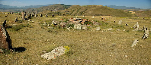
Zorats Karer
Zorats Karer (Armenian: Զորաց Քարեր), also called Karahunj or Carahunge) is an ancient archaeological site near the city of Sisian in the Syunik province of Armenia.
Located at 39.55 46.03 (Lat./Long.); Less than 10 km away
Spandaryan Reservoir
Spandaryan Reservoir (also Spandarian) is a large man-made lake located southeast of Gorayk, in the municipality of Spandaryan, Syunik Province in Armenia. It was built around 1980 in the Arpa River basin, reportedly connected to it by a 9-mile long tunnel. It reportedly has a breeding colony of Lesser kestrels, the only known in Armenia. It contains the Spandaryan Hydro Power Plant.
Located at 39.67 45.81 (Lat./Long.); Less than 15 km away
Yeremes
Yeremes (also, Irimis and Aramis) is a town in the Syunik Province of Armenia.
Located at 39.46 46.10 (Lat./Long.); Less than 20 km away
Tskhouk-Karckar
Tskhouk-Karckar is a group of pyroclastic cones which is located in the central part of the Siunik volcanic ridge at the border of Armenia and Azerbaijan 60 km SE of Lake Sevan.
Located at 39.73 46.02 (Lat./Long.); Less than 21 km away
Pictures
Historical Weather
Related Locations
Information of geographic nature is based on public data provided by geonames.org, CIA world facts book, Unesco, DBpedia and wikipedia. Weather is based on NOAA GFS.