Delve into Grimbergen in Belgium
Grimbergen in the region of Flanders with its 33,561 residents is a city in Belgium - some 6 mi or ( 9 km ) North of Brussels , the country's capital .
Current time in Grimbergen is now 04:36 PM (Saturday) . The local timezone is named " Europe/Brussels " with a UTC offset of 1 hours. Depending on your travel modalities, these larger destinations might be interesting for you: Utrecht, The Hague, Haarlem, Amsterdam, and Veldkant. While being here, make sure to check out Utrecht . We encountered some video on the web . Scroll down to see the most favourite one or select the video collection in the navigation. Are you curious about the possible sightseeing spots and facts in Grimbergen ? We have collected some references on our attractions page.
Videos
Bruxelles Atomium e Mini Europe
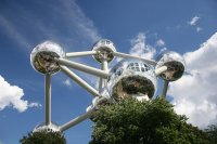
The Atomium was originally built for Expo '58, the 1958 Brussels World's Fair. Designed by André Waterkeyn it stands 102 meters (335 ft) tall, each sphere 18 meters in diameter. Originally planned to ..
European Union
The European Union (EU) is an economic and political union of 27 member states, located primarily in Europe. It was established by the Treaty of Maastricht on 1 November 1993, upon the foundations of ..
Atomium Brüssel (2.6.2011)
..
SAMAN DANCE AT BRUSSELS HOLIDAY SHOW 05/FEB/2011
..
Videos provided by Youtube are under the copyright of their owners.
Interesting facts about this location
Grimbergen Abbey
Grimbergen Abbey was a Premonstratensian monastery in Grimbergen, Flemish Brabant, Belgium, established in 1128 in the place of an earlier foundation of Augustinian Canons. The abbey itself was dissolved in 1796 in the aftermath of the French Revolution, but the abbey church of Saint Servatius survived as the parish church of Grimbergen. The building in its present form dates from 1660 and is considered one of the most beautiful and best-integrated Baroque churches in the Low Countries.
Located at 50.93 4.37 (Lat./Long.); Less than 0 km away
Neder-Over-Heembeek
Neder-Over-Heembeek is a northern part of the City of Brussels municipality in Belgium. It is a municipality which lost its municipality status when it was merged with the City of Brussels. Now it is a section of that municipality, and a predominantly industrial zone, remarkable principally for the Military Hospital, which is the National Burns and Poisons center.
Located at 50.90 4.38 (Lat./Long.); Less than 4 km away
Onze-Lieve-Vrouw ten Troost
The Onze-Lieve-Vrouw ten Troost Kerk (Church of Our Lady of Consolation), simply known as the Troostkerk, is a basilica in Vilvoorde, Belgium. The history of the church and its Carmelite monastery (the oldest in Western Europe) go back 800 years. It was consecrated as a basilica on May 7, 2006 by Cardinal Godfried Danneels.
Located at 50.93 4.43 (Lat./Long.); Less than 4 km away
Heysel Plateau
The Heysel Exhibition Park is the place in the north of the centre of Brussels, Belgium, where the Brussels International Exposition (1935) and the Expo '58 took place. The Atomium, built for the World's Fair of 1958, is the most impressive monument in the Heysel Park. The Centenary Palace is one of the remaining buildings of the World's Fair of 1935. Currently it's still being used for trade fairs. The Heysel Park is also the location of the Heysel Stadium, built in 1930.
Located at 50.90 4.34 (Lat./Long.); Less than 5 km away
Expo 58
Expo 58, also known as the Brussels World’s Fair (Dutch: Brusselse Wereldtentoonstelling, French: Exposition Universelle et Internationale de Bruxelles), was held from 17 April to 19 October 1958. It was the first major World's Fair after World War II.
Located at 50.90 4.34 (Lat./Long.); Less than 5 km away
Pictures
Historical Weather
Related Locations
Information of geographic nature is based on public data provided by geonames.org, CIA world facts book, Unesco, DBpedia and wikipedia. Weather is based on NOAA GFS.


