-
You are here:
- Homepage »
- France »
- Pays de la Loire » Barbatre

Barbatre Destination Guide
Explore Barbatre in France
Barbatre in the region of Pays de la Loire with its 1,517 inhabitants is a town in France - some 248 mi or ( 399 km ) South-West of Paris , the country's capital city .
Current time in Barbatre is now 02:54 AM (Saturday) . The local timezone is named " Europe/Paris " with a UTC offset of 1 hours. Depending on the availability of means of transportation, these more prominent locations might be interesting for you: Vannes, Saint-Jean-de-Monts, Rennes, Notre-Dame-de-Monts, and Noirmoutier-en-l'Ile. Since you are here already, make sure to check out Vannes . We saw some video on the web . Scroll down to see the most favourite one or select the video collection in the navigation. Where to go and what to see in Barbatre ? We have collected some references on our attractions page.
Videos
Survol du Pays des Monts en paramoteur
Paramoteur, survol du pays des Monts, Vendée (85) Pays de Loire. Passage du Gois , Île de Noirmoutier, Saint Jean de Monts, st-Hilaire de Riez, la Barre de Monts, les Marais de Monts. ..
100302-Noirmoutier-Barbatre post Xynthia (R09)
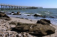
La plage de Barbâtre après la tempête Xynthia du 28/02/2010. Principal changement : la dune sacrément grignotée. Prise de vue CANON FS100 ..
CDS Noirmoutier Passage du Gois
Caravane du sel du 22 mai 2010 Caravane du sel fafou filoo christian gepeteau jlg0635 commencal jf93 ristic galeni lapouble armen29 zil850 celtas artige rcmd ..
High Speed Packing Up A Bell Tent
Packing up a bell tent and way too much stuff into a VW Passat. This was taken at Indigo Camping, Bois de la Chaise, Noirmoutier-en-l'Ile, France. It shows us packing away all the stuff we lugged arou ..
Videos provided by Youtube are under the copyright of their owners.
Interesting facts about this location
Noirmoutier (island)
The island of Noirmoutier is off the Atlantic coast of France in the Vendée department. Parts of the island have been reclaimed from the sea. In 2005 it served as the finish of the Tour de France prologue. The communes of the island are grouped into a communauté de communes.
Located at 46.97 -2.20 (Lat./Long.); Less than 3 km away
Passage du Gois
Le Passage de Gois ou Gôa is a natural, periodically flooded passage leading to the island of Noirmoutier in France. It is located between Île de Noirmoutier and Beauvoir-sur-Mer, in the department of Vendée. It is flooded twice a day by the high tide. Every year, a foot race – the Foulées du Gois– is held across it, starting at the onset of the high tide.
Located at 46.93 -2.13 (Lat./Long.); Less than 4 km away
Château de Noirmoutier
The Château de Noirmoutier is a castle on the Île de Noirmoutier in the Vendée département of France. It dominates the town of Noirmoutier-en-l'Île with its almost 20m (~65 ft) high keep. The castle is very well preserved and a fine example of 12th century medieval architecture.
Located at 47.00 -2.24 (Lat./Long.); Less than 8 km away
Sainte-Marie-sur-Mer
Sainte-Marie-sur-Mer is a former commune in the Pays de Retz, situated in the Loire-Atlantique département and in the French région of Pays de la Loire. From 1973, it was absorbed by the neighbouring commune of Pornic and from July 1, 2007 it became a subdivision of this commune. The commune forms a part of Brittany, in the traditional county of Retz and in the historical Pays Nantais. The inhabitants of Sainte-Marie are known as the Sanmaritains and Sanmaritaines.
Located at 47.11 -2.13 (Lat./Long.); Less than 19 km away
Pictures
Related Locations
Information of geographic nature is based on public data provided by geonames.org, CIA world facts book, Unesco, DBpedia and wikipedia. Weather is based on NOAA GFS.


