
Explore Kara Osta in Latvia
Kara Osta in the region of Liepāja is a town in Latvia - some 120 mi or ( 193 km ) West of Riga , the country's capital city .
Current time in Kara Osta is now 05:31 AM (Monday) . The local timezone is named " Europe/Riga " with a UTC offset of 2 hours. Depending on the availability of means of transportation, these more prominent locations might be interesting for you: Vitini, Ventspils, Skrunda, Shkede, and Saraiki. Since you are here already, make sure to check out Vitini . We encountered some video on the web . Scroll down to see the most favourite one or select the video collection in the navigation. Where to go and what to see in Kara Osta ? We have collected some references on our attractions page.
Videos
Shark area crash (Summer Sound festival 2011 . Liepaja)
psc... 4udom nikto ne postradal. ..
Liepaja Hostel, Beach Hostel For Travellers
Liepaja Travellers Beach Hostel for Backpackers. Australian owned for the benefit of the foreign traveller. They have also Barons Hostel in Riga. ..
Liva Hotel
Basic hotel information ( in Latvian language) ..
Bicycle trip around Liepaja Latvia
Visit Liepaja the third largest city in Latvia, a city living on a stretch of sand between the amber sea and a lake for more than 750 ... all » years. See Holy Trinity Church with the world's largest ..
Videos provided by Youtube are under the copyright of their owners.
Interesting facts about this location
Karosta
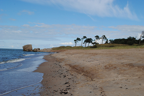
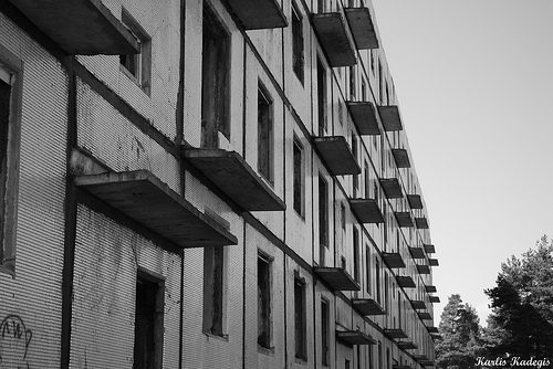
Karosta (War Port) is a neighbourhood in the north of Liepāja in western Latvia by the Baltic sea. Karosta was constructed in 1890-1906 as a naval base for the Russian Tsar Alexander III, and later served as a base for the Soviet Baltic Fleet. Now it is a very popular place for tourists and artists, since there are unique sights and interesting places, such as the scenic seascapes with partially blasted fortresses on the Baltic shore.
Located at 56.55 21.01 (Lat./Long.); Less than 1 km away
Liepāja Special Economic Zone
Liepāja Special Economic Zone - is a zone in Liepāja, Latvia with a lowered tax rates, compared to the rest of the territory of Latvia. Liepāja Special Economic zone was established in 1997 for a 20-year period with the aim of developing trade, industry, shipping and air traffic, as well as international freight flow via Latvia. The goal of the Liepāja SEZ is to attract investments for the development of manufacturing and infrastructure, and creation of new jobs.
Located at 56.53 20.98 (Lat./Long.); Less than 3 km away
Liepāja Station
Liepāja Station is a railway station on the Jelgava – Liepāja Railway.
Located at 56.52 21.02 (Lat./Long.); Less than 3 km away
Liepāja District
Liepāja District was an administrative division of Latvia, located in the Courland region, in the country's west. Districts were eliminated during the administrative-territorial reform in 2009.
Located at 56.51 21.01 (Lat./Long.); Less than 4 km away
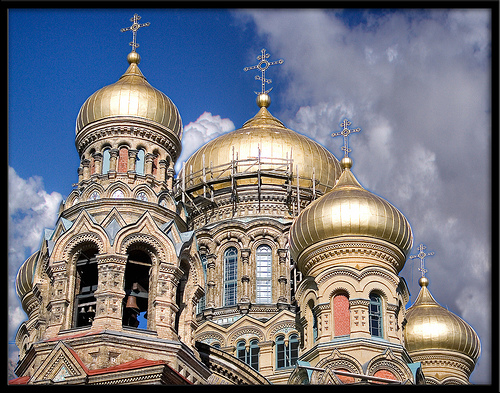
Holy Trinity Cathedral, Liepāja
Liepāja Holy Trinity Lutheran Cathedral (Latvian: Liepājas Svētās Trīsvienības katedrāle) is a historical Lutheran cathedral in Liepāja, Latvia. The foundation stone of the church was laid in 1742 and on December 5, 1758, the church was solemnly consecrated. The church interior and exterior architecture is built in the late baroque style with classic features. The cathedral interior is characterized by its Rococo features and luxurious furnishings with wood carvings and gold plating.
Located at 56.51 21.01 (Lat./Long.); Less than 4 km away
Pictures
Historical Weather
Related Locations
Information of geographic nature is based on public data provided by geonames.org, CIA world facts book, Unesco, DBpedia and wikipedia. Weather is based on NOAA GFS.