-
You are here:
- Homepage »
- New Zealand »
- Southland » Bluff

Bluff Destination Guide
Touring Bluff in New Zealand
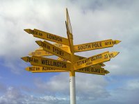
Bluff in the region of Southland with its 1,938 citizens is a city located in New Zealand - some 487 mi or ( 784 km ) South-West of Wellington , the country's capital city .
Time in Bluff is now 01:34 PM (Monday) . The local timezone is named " Pacific/Auckland " with a UTC offset of 13 hours. Depending on your travel resources, these more prominent places might be interesting for you: Woodend, Tisbury, Invercargill, Dunedin, and Awarua Plains. Being here already, consider visiting Woodend . We collected some hobby film on the internet . Scroll down to see the most favourite one or select the video collection in the navigation. Check out our recommendations for Bluff ? We have collected some references on our attractions page.
Videos
Daughters first fishing trip
Took my daughter down to the local Mataura River and had a fun afternoon there. She did well for a three year old on her first trip to stay there for a few hours with dad :) ..
Videos provided by Youtube are under the copyright of their owners.
Interesting facts about this location
Bluff, New Zealand
Bluff is a town and seaport in the Southland region, on the southern coast of the South Island of New Zealand. It is the southern-most town in New Zealand and, despite Slope Point being further to the south, is colloquially used to refer to the southern extremity of the country (particularly in the phrase "from Cape Reinga to The Bluff"). According to the 2006 census, the usually resident population was 1,850, a decrease of 85 since 2001.
Located at -46.60 168.33 (Lat./Long.); Less than 0 km away
Tiwai Point
Tiwai Point lies at the entrance to Bluff Harbour on the southern coast of the South Island of New Zealand. A spit which extends from the western end of the Awarua Plain, it lies between Awarua Bay to the north and Foveaux Strait to the south. It is famous for the Tiwai Point Aluminium Smelter, one of the largest industrial facilities in New Zealand.
Located at -46.60 168.36 (Lat./Long.); Less than 2 km away
Awarua Plains
"Awarua" redirects here. For other uses, see Awarua (disambiguation). The Awarua Plain is a large area of wetland to the east of Bluff, New Zealand. Covering an area of around 600 km², the plain stretches for 35 kilometres along the coast of Foveaux Strait. This stretch of coast includes the peninsula of Tiwai Point, Awarua Bay, the Waituna Lagoon, and Toetoes Bay.
Located at -46.53 168.48 (Lat./Long.); Less than 14 km away
Foveaux Strait
Foveaux Strait (Māori: Te Ara a Kiwa) separates Stewart Island/Rakiura, New Zealand's third largest island, from the South Island. Three large bays, Te Waewae Bay, Oreti Beach and Toetoes Bay, sweep along the strait's northern coast, which also hosts Bluff township and harbour. Across the strait lie the Solander Islands, Stewart Island/Rakiura and Ruapuke Island.
Located at -46.67 168.18 (Lat./Long.); Less than 14 km away
Oreti River
The Oreti (or New) River is one of the main rivers of Southland, New Zealand, and is 170 kilometres in length. The river has been identified as an Important Bird Area by BirdLife International because, for much of its length, it supports breeding colonies of Black-billed Gulls. The Oreti has its headwaters close to the Mavora Lakes between Lake Te Anau and Lake Wakatipu, and flows south across the Southland Plains to its outflow into Foveaux Strait at the southeastern end of Oreti Beach.
Located at -46.47 168.28 (Lat./Long.); Less than 15 km away
Pictures
Historical Weather
Related Locations
Information of geographic nature is based on public data provided by geonames.org, CIA world facts book, Unesco, DBpedia and wikipedia. Weather is based on NOAA GFS.


