-
You are here:
- Homepage »
- United Kingdom »
- England » Cricklade

Cricklade Destination Guide
Explore Cricklade in United Kingdom
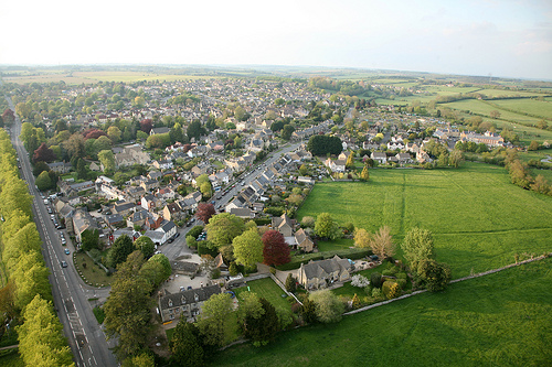
Cricklade in the region of England with its 4,050 inhabitants is a town in United Kingdom - some 75 mi or ( 121 km ) West of London , the country's capital city .
Current time in Cricklade is now 07:15 PM (Wednesday) . The local timezone is named " Europe/London " with a UTC offset of 0 hours. Depending on the availability of means of transportation, these more prominent locations might be interesting for you: Royal Wootton Bassett, Wolverhampton, Wanborough, Swindon, and Southampton. Since you are here already, make sure to check out Royal Wootton Bassett . We encountered some video on the web . Scroll down to see the most favourite one or select the video collection in the navigation. Where to go and what to see in Cricklade ? We have collected some references on our attractions page.
Videos
Mad River Journeys - The Upper Thames
One of a series of classic open boat journeys. The River Thames from Cricklade to Lechlade. ..
Summertime in the UK
Peak summertime in the UK! ..
Swindon and Cricklade Thumper + Cabride 05/03/2011
A day out on the 5th March 2011 on the Swindon and Cricklade railway. It was the first time the new southern extension was open. The train is DEMU Class 207203. Also in this video is a mini cabride fr ..
Swindon & Cricklade Railway 2
Salmon pulling into Hayes Knoll ..
Videos provided by Youtube are under the copyright of their owners.
Interesting facts about this location
North Meadow, Cricklade
North Meadow, Cricklade is a hay meadow near the village of Cricklade, in Wiltshire, England. It is 24.6 hectares in size. It is a traditionally managed lowland hay-meadow, or lammas land, and is grazed in common between 12 August and 12 February each year, and cut for hay no earlier than 1 July. This pattern of land use and management has existed for many centuries and has resulted in the species rich grassland flora and fauna present on the site.
Located at 51.65 -1.87 (Lat./Long.); Less than 1 km away
River Churn
The River Churn is one of the Cotswold rivers that feeds into the River Thames catchment. It rises at Seven Springs, Gloucestershire near Cheltenham, Gloucestershire, England and flows south across the Cotswold dip slope, passing through Cirencester and joining the River Thames near Cricklade in Wiltshire.
Located at 51.65 -1.88 (Lat./Long.); Less than 2 km away
Down Ampney
Down Ampney is a medium-sized village located in Cotswold district in Gloucestershire, in England. It is off the A417 which runs between Cirencester and Faringdon (in Oxfordshire) on the A420, and about 5 km north of Cricklade, which is on the A419 which runs from Cirencester to Swindon, Wiltshire. Down Ampney was notable in medieval times as one of the principal seats of the powerful Hungerford family and a number of elaborate family monuments survive in the village church.
Located at 51.67 -1.85 (Lat./Long.); Less than 3 km away
RAF Blakehill Farm
RAF Blakehill Farm was an RAF base situated in Wiltshire, England. The station was opened in 1944 as a base for transport aircraft of No. 46 Group Transport Command. In 1948 the airfield was a satellite of RAF South Cerney and used by training aircraft before the airfield closed in 1952 and was returned to agricultural use. The site is now a Wiltshire Wildlife Trust nature reserve.
Located at 51.62 -1.89 (Lat./Long.); Less than 3 km away
Ermin Street
Ermin Street or Ermin Way is one of the great Roman roads of Britain. It runs from Gloucester via Cirencester to Silchester. Much of it is now covered by the modern A417, A419 and B4000 roads.
Located at 51.63 -1.82 (Lat./Long.); Less than 3 km away
Pictures
Related Locations
Information of geographic nature is based on public data provided by geonames.org, CIA world facts book, Unesco, DBpedia and wikipedia. Weather is based on NOAA GFS.