-
You are here:
- Homepage »
- United States »
- Arizona » Joseph City

Joseph City Destination Guide
Discover Joseph City in United States
Joseph City in the region of Arizona with its 1,386 habitants is a place located in United States - some 1,849 mi or ( 2975 km ) West of Washington , the country's capital .
Local time in Joseph City is now 01:13 AM (Thursday) . The local timezone is named " America/Phoenix " with a UTC offset of -7 hours. Depending on your mobility, these larger cities might be interesting for you: Holbrook, Clifton, Flagstaff, Florence, and Phoenix. When in this area, you might want to check out Holbrook . We discovered some clip posted online . Scroll down to see the most favourite one or select the video collection in the navigation. Are you looking for some initial hints on what might be interesting in Joseph City ? We have collected some references on our attractions page.
Videos
Route 66 da Rimini / Cesena al deserto dell'Arizona
www.rut66.it ..
Racing the Train on 66
Us versus the BNSF on a quiet stretch of frontage road / old 66 west of Joseph City, AZ. Didn't really exceed the speed limit (I think.) Part of our Big 2008 Road Trip. ..
HOW TO MAKE EASY MONEY ON THE INTERNET FREE WEBSITE AMAZING FEATURES NO COST MONTHLY INCOME Part 1
www.ez.com Enjoy this free test drive. You will receive two free gifts when you go to the site or email me at shopzz@rocketmail.com You will get a free website which this video is describing and you w ..
Road Trip - Truck Accident in Arizona
..
Videos provided by Youtube are under the copyright of their owners.
Interesting facts about this location
Joseph City, Arizona
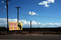
Joseph City (elevation 5,000 ft) is an unincorporated community located in Navajo County, Arizona, United States. It is located on Interstate 40 about eighty miles east of Flagstaff and about thirty-five miles west of Petrified Forest National Park. In 2010, there were 1,386 inhabitants. It is the site of the Jack Rabbit Trading Post, a famous Route 66 landmark.
Located at 34.96 -110.33 (Lat./Long.); Less than 0 km away
KDJI
KDJI is a radio station broadcasting a News Talk Information format. Licensed to Holbrook, Arizona, USA, the station is currently owned by Petracom of Holbrook, L.L.C. and features programing from ABC Radio and Premiere Radio Networks.
Located at 34.90 -110.19 (Lat./Long.); Less than 14 km away
KJNN-LP
KJNN-LP (94.3 FM, "Radio 74") is an American low-power FM radio station licensed to serve the community of Holbrook, Arizona. The station is licensed to Holbrook Adventist Educational Radio Corp. and operated as a ministry of the Holbrook Seventh-Day Adventist Indian School. It airs a Christian radio format including Christian music and Bible teaching programs. The station was assigned the KJNN-LP call letters by the Federal Communications Commission on April 28, 2004.
Located at 34.88 -110.19 (Lat./Long.); Less than 15 km away
Holbrook, Arizona
Holbrook is a city in Navajo County, Arizona, United States. According to 2006 Census Bureau estimates, the population of the city was 5,126. The city is the county seat of Navajo County. Holbrook was founded in 1881 or 1882, when the railroad was built, and named to honor the first chief engineer of the Atlantic and Pacific Railroad.
Located at 34.91 -110.16 (Lat./Long.); Less than 17 km away
Holbrook railroad station
Holbrook was a train station in Holbrook, Arizona, United States, formerly served by the trains of the Atchison, Topeka and Santa Fe Railway prior to the creation of Amtrak in 1971.
Located at 34.90 -110.16 (Lat./Long.); Less than 17 km away
Pictures
Related Locations
Information of geographic nature is based on public data provided by geonames.org, CIA world facts book, Unesco, DBpedia and wikipedia. Weather is based on NOAA GFS.

