-
You are here:
- Homepage »
- United States »
- California » Lost Hills

Lost Hills Destination Guide
Explore Lost Hills in United States
Lost Hills in the region of California with its 2,412 inhabitants is a town in United States - some 2,335 mi or ( 3759 km ) West of Washington , the country's capital city .
Current time in Lost Hills is now 09:21 AM (Friday) . The local timezone is named " America/Los Angeles " with a UTC offset of -7 hours. Depending on the availability of means of transportation, these more prominent locations might be interesting for you: Bakersfield, Fresno, LA, North Belridge, and Sacramento. Since you are here already, make sure to check out Bakersfield . We saw some video on the web . Scroll down to see the most favourite one or select the video collection in the navigation. Where to go and what to see in Lost Hills ? We have collected some references on our attractions page.
Videos
Trip to store gets Jack a black eye and EZ creates thrift store rap SONG for Jack and Jill
This weeks venture to the thrift store leaves me with injury.....watch to find out what happened. Check Last weeks video: youtu.be youtu.be ..
Videos provided by Youtube are under the copyright of their owners.
Interesting facts about this location
Lost Hills, California
Lost Hills (formerly, Lost Hill) is a census-designated place (CDP) in Kern County, California, United States. Lost Hills is located 42 miles west-northwest of Bakersfield, at an elevation of 305 feet (93 m). The population is 2,412 at the 2010 census, up from 1,938 at the 2000 census. About 75% of the population is engaged in agricultural positions. A rest stop by Interstate 5 including restaurants, gasoline stations, and motels is located about one mile (1.6 km) from the town.
Located at 35.62 -119.69 (Lat./Long.); Less than 0 km away
Lost Hills Airport
Lost Hills Airport, also known as Lost Hills-Kern County Airport, is a public airport located one mile (2 km) northeast of the central business district (CBD) of Lost Hills, in Kern County, California, USA. The airport is mostly used for general aviation.
Located at 35.62 -119.69 (Lat./Long.); Less than 1 km away
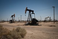
Lost Hills Oil Field
The Lost Hills Oil Field is a large oil field in the Lost Hills Range, north of the town of Lost Hills in western Kern County, California, in the United States.
Located at 35.62 -119.72 (Lat./Long.); Less than 3 km away
North Belridge Oil Field
The North Belridge Oil Field is a large oil field along California State Route 33 in the northwestern portion of Kern County, California, about 45 miles west of Bakersfield. It is contiguous with the larger South Belridge Oil Field to the southeast, in a region of highly productive and mature fields.
Located at 35.55 -119.79 (Lat./Long.); Less than 12 km away
South Belridge Oil Field
The South Belridge Oil Field is a large oil field in northwestern Kern County, San Joaquin Valley, California, about forty miles west of Bakersfield. Discovered in 1911, and having a cumulative production of over 1.5 billion barrels of oil at the end of 2008, it is the fourth-largest oil field in California, after the Midway-Sunset Oil Field, Kern River Oil Field, and Wilmington Oil Field, and is the sixth-most productive field in the United States.
Located at 35.46 -119.72 (Lat./Long.); Less than 18 km away
Pictures
Related Locations
Information of geographic nature is based on public data provided by geonames.org, CIA world facts book, Unesco, DBpedia and wikipedia. Weather is based on NOAA GFS.

