-
You are here:
- Homepage »
- United States »
- California » Montara

Montara Destination Guide
Discover Montara in United States
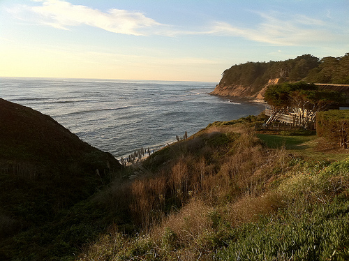
Montara in the region of California with its 2,909 habitants is a place located in United States - some 2,445 mi or ( 3934 km ) West of Washington , the country's capital .
Local time in Montara is now 02:34 PM (Saturday) . The local timezone is named " America/Los Angeles " with a UTC offset of -7 hours. Depending on your mobility, these larger cities might be interesting for you: Bakersfield, Burlingame, El Granada Mobile Home Park, Fresno, and Half Moon Bay. When in this area, you might want to check out Bakersfield . We discovered some clip posted online . Scroll down to see the most favourite one or select the video collection in the navigation. Are you looking for some initial hints on what might be interesting in Montara ? We have collected some references on our attractions page.
Videos
Montara Wedding Location - Weddings by the Sea
Montara State Beach wedding ceremony location is north of Half Moon Bay and South of Pacifica California. www.weddingsbythesea.com ..
Wave Runners
The girls in the waves of the Pacific ..
A Funbug Christmas
An original song and video by Julie Vaughn. I uploaded and put this video together last year in 2008. I wanted to write a peppy upbeat Christmas Song. I play the guitar part on this song but the rest ..
Moss beach distillery
Moss beach distillery ..
Videos provided by Youtube are under the copyright of their owners.
Interesting facts about this location
Montara, California
Montara is a census-designated place (CDP) in San Mateo County, California, United States. The population was 2,909 at the 2010 census. Nearby communities include Moss Beach and Princeton-by-the-Sea.
Located at 37.54 -122.51 (Lat./Long.); Less than 1 km away
Martini Creek
Martini Creek is a coastal stream whose watershed lies entirely within San Mateo County, California, United States on the western exposures of the Montara mountain block, discharging to the Pacific Ocean. It flows about 2 miles from its source on Montara Mountain to its mouth in Montara State Beach. This stream has a drainage basin composed of open space and agricultural lands.
Located at 37.55 -122.51 (Lat./Long.); Less than 1 km away
San Vicente Creek (San Mateo County)
San Vicente Creek (Spanish for "St. Vincent") is a 3.9-mile-long coastal stream in northern California which flows entirely within San Mateo County and discharges to the Pacific Ocean. Its waters rise on the west facing slopes of the Montara Mountain, block and its mouth is at the unincorporated community of Moss Beach, within the Fitzgerald Marine Reserve.
Located at 37.52 -122.52 (Lat./Long.); Less than 2 km away
Moss Beach Distillery
Moss Beach Distillery is a restaurant in Moss Beach, California, located on a cliff which overlooks the Pacific Ocean. It is officially designated as a California Point of Historical Interest. Originally established in 1927 as a speakeasy, it converted into a successful restaurant after the repeal of Prohibition in 1933.
Located at 37.52 -122.51 (Lat./Long.); Less than 3 km away
Half Moon Bay Airport
Half Moon Bay Airport is a county-owned public use airport in San Mateo County, California, United States. It is located five nautical miles (9 km) northwest of the central business district of Half Moon Bay, California. The airport is on the Pacific Coast, south of San Francisco.
Located at 37.51 -122.50 (Lat./Long.); Less than 3 km away
Pictures

Related Locations
Information of geographic nature is based on public data provided by geonames.org, CIA world facts book, Unesco, DBpedia and wikipedia. Weather is based on NOAA GFS.