-
You are here:
- Homepage »
- United States »
- New Hampshire » Warren

Warren Destination Guide
Delve into Warren in United States
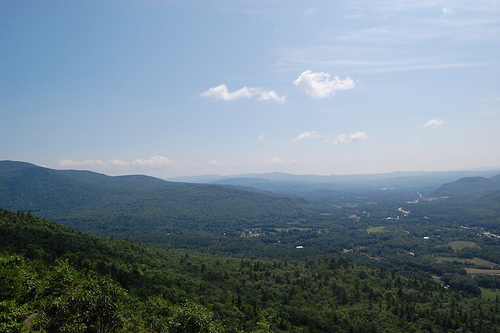
Warren in the region of New Hampshire with its 930 residents is a city in United States - some 438 mi or ( 704 km ) North-East of Washington , the country's capital .
Current time in Warren is now 12:13 PM (Sunday) . The local timezone is named " America/New York " with a UTC offset of -4 hours. Depending on your travel modalities, these larger destinations might be interesting for you: Philadelphia, Hartford, Boston, Center Haverhill, and Cheever. While being here, make sure to check out Philadelphia . We encountered some video on the web . Scroll down to see the most favourite one or select the video collection in the navigation. Are you curious about the possible sightseeing spots and facts in Warren ? We have collected some references on our attractions page.
Videos
Irene causes flooding in Wentworth NH
After getting pounded by Irene the Baker river located in Wentworth New Hampshire crested it's banks causing damage in many locations. This shot was taken on Rt 25 just past Turner Rd. There are multi ..
Hilltop Acres B&B, Wentworth, NH
Visit Hilltop Acres Bed & Breakfast in scenic Wentworth, NH ..
Moosilauke - December 6, 2008
Sandi and Greg hike up Glencliff trail to the summit of Mount Moosilauke - elevation 4802 ..
Mt. Carr
Mt. Carr 3453 feet Warren, Wentworth New Hampshire Start time: 6:30 AM 12/30/2010 occip.it Link to panoramic view twitpic.com and the Photo occip.it Halfway point. 2000 feet panoramic ..
Videos provided by Youtube are under the copyright of their owners.
Interesting facts about this location
Grafton County, New Hampshire
Grafton County is a county located in the U.S. state of New Hampshire. As of the 2010 census, the population was 89,118. Its county seat is North Haverhill, which is a village within the town of Haverhill. Until 1972, the county courthouse and other offices were located in downtown Woodsville, a larger village within the town of Haverhill. Grafton County is part of the Lebanon, NH–VT Micropolitan Statistical Area. The county is the home of Dartmouth College and Plymouth State University.
Located at 43.93 -71.84 (Lat./Long.); Less than 4 km away
East Branch Baker River
The East Branch of the Baker River is a 3.1-mile-long river located in western New Hampshire in the United States. It is a tributary of the Baker River, part of the Pemigewasset River and Merrimack River watersheds. The river rises on the southernmost slopes of Mount Moosilauke in the town of Woodstock. Flowing south, it quickly enters the town of Warren and crosses twice under Route 118 before joining the main stem of the Baker.
Located at 43.96 -71.83 (Lat./Long.); Less than 6 km away
Glencliff, New Hampshire
Glencliff is a village within the White Mountain National Forest in the town of Warren in Grafton County, New Hampshire, United States.
Located at 43.98 -71.89 (Lat./Long.); Less than 7 km away
Lake Tarleton
Lake Tarleton is a 334-acre water body located in Grafton County on the western edge of the White Mountains in New Hampshire. The lake is located in the towns of Piermont and Warren. Water from Lake Tarleton flows via Eastman Brook west to the Connecticut River. Kingswood Camp for Boys is located on the lake. The Appalachian Trail runs nearby on Mount Mist, then continues north to Mount Moosilauke, with both mountains overlooking the lake.
Located at 43.98 -71.96 (Lat./Long.); Less than 8 km away
Stinson Lake, New Hampshire
Stinson Lake is a village in the town of Rumney in Grafton County, New Hampshire, United States. It is located at the south end of Stinson Lake, around the lake's outlet. The village is 4 miles north of the village of Rumney, via Stinson Lake Road. Stinson Lake has a separate ZIP code (03274) from the rest of Rumney.
Located at 43.86 -71.81 (Lat./Long.); Less than 10 km away
Pictures
Related Locations
Information of geographic nature is based on public data provided by geonames.org, CIA world facts book, Unesco, DBpedia and wikipedia. Weather is based on NOAA GFS.