-
You are here:
- Homepage »
- United States »
- Oregon » Hammond

Hammond Destination Guide
Touring Hammond in United States
Hammond in the region of Oregon with its 589 citizens is located in United States - some 2,404 mi or ( 3869 km ) West of Washington , the country's capital city .
Time in Hammond is now 12:27 AM (Friday) . The local timezone is named " America/Los Angeles " with a UTC offset of -7 hours. Depending on your budget, these more prominent places might be interesting for you: Astoria, Carnahan, Eugene, Hillsboro, and Jeffers Garden. Being here already, consider visiting Astoria . We collected some hobby film on the internet . Scroll down to see the most favourite one or select the video collection in the navigation. Check out our recommendations for Hammond ? We have collected some references on our attractions page.
Videos
Astoria,Oregon
A video tour of Astoria and it's tourist attractions. This is an excerpt from our DVD "Destination:The Coast", and hour-long tour of the Oregon Coast. ..
How to Fillet a Tuna
This bonus video that came out of the story we filmed about West Coast albacore at a micro-cannery along the Oregon Coast. This is behind the scenes impromptu shooting of a veteran fish filleter, part ..
Albacore Tuna: A Micro-Cannery Flourishes
In the1970s, Oregon's coastal fishing industry, consisting for the most part of small, family-owned boats, was being devastated by the rise of large foreign fleets competing for ever-decreasing stocks ..
Behind the Scenes: Civil War Reenactment
www.discoverourcoast.com A behind the scenes look at a Civil War battle reenactment at Fort Stevens State Park, Oregon. ..
Videos provided by Youtube are under the copyright of their owners.
Interesting facts about this location
Fort Stevens (Oregon)
Fort Stevens was an American military installation that guarded the mouth of the Columbia River in the state of Oregon. Built near the end of the American Civil War, it was named for slain Civil War general and former Washington Territory governor, Isaac Stevens. The fort was an active military reservation from 1863–1947. The fort is listed on the National Register of Historic Places.
Located at 46.20 -123.96 (Lat./Long.); Less than 1 km away
Bombardment of Fort Stevens
The Bombardment of Fort Stevens occurred in June 1942, during early months of the Pacific War. An Imperial Japanese submarine fired on Fort Stevens which protected the Oregon side of the Columbia River's Pacific entrance.
Located at 46.20 -123.96 (Lat./Long.); Less than 1 km away
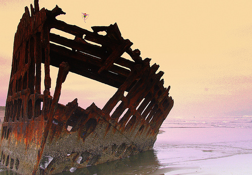
Peter Iredale
The Peter Iredale was a four-masted steel barque sailing vessel that ran ashore October 25, 1906, on the Oregon coast en route to the Columbia River. It was abandoned on Clatsop Spit near Fort Stevens in Warrenton about four miles (6 km) south of the Columbia River channel. Wreckage is still visible, making it a popular tourist attraction as one of the most accessible shipwrecks of the Graveyard of the Pacific.
Located at 46.18 -123.98 (Lat./Long.); Less than 3 km away
Clatsop Spit
Clatsop Spit is a giant sand spit on the Pacific coast along U.S. 101 between Astoria and the north end of Tillamook Head in Clatsop County, northwest Oregon at the mouth of the Columbia River. The Clatsop Spit was formed by Columbia River sediment brought to the coast by the river flow after the last ice age ended approximately 8500 years ago and the ocean level rose. Here it worked over and shaped by the wind and the waves until a vast and sandy plain was formed.
Located at 46.23 -124.01 (Lat./Long.); Less than 6 km away
McGowan, Washington
McGowan, Washington was a stop on the Ilwaco Railway and Navigation Company's narrow gauge line that ran on the Long Beach Peninsula in Pacific County, Washington, USA from 1889 to 1930. In the late 19th century, P.J. McGowan bought land in the area for $1,200, and built his house, a dock and a salmon cannery on the site. During the railroad times, the main line and a passing siding ran through McGowan. McGowan is just west of the north end of the Astoria-Megler Bridge.
Located at 46.25 -123.91 (Lat./Long.); Less than 6 km away
Pictures
Related Locations
Information of geographic nature is based on public data provided by geonames.org, CIA world facts book, Unesco, DBpedia and wikipedia. Weather is based on NOAA GFS.